
The Moonie Highway is a state highway of Queensland, Australia. Part of State Route 49, it leaves the Warrego Highway at Dalby and runs for over 290 km until it reaches St George. From there, State Route 49 continues west as the Balonne Highway. From Dalby, it continues north-east as the Bunya Highway.

The Barkly Highway is a national highway in Queensland and the Northern Territory in Australia. It is the only sealed road between Queensland and the Northern Territory.

The Captain Cook Highway is a short, regional highway in Queensland which originates in Cairns and terminates in Mossman, where it joins Mossman-Daintree Road, continuing to Daintree. It is a state-controlled regional road.

Millaa Millaa is a rural town and locality in the Tablelands Region, Queensland, Australia. In the 2016 census, the locality of Millaa Millaa had a population of 514 people.

Millaa Millaa Falls is a heritage-listed plunge waterfall at Theresa Creek Road, Millaa Millaa, Tablelands Region, Queensland, Australia. It was added to the Queensland Heritage Register on 5 December 2005.
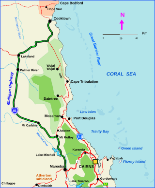
The Mulligan Highway is a state highway in Queensland, Australia. It runs for approximately 266 km between Mareeba and Cooktown, on the east coast of Cape York Peninsula where it terminates. It is signed as State Route 81 from Mareeba to Lakeland and State Route 40 from Lakeland to Cooktown. It is a state-controlled regional road.

The Wide Bay Highway is a short state highway of Queensland, Australia running between Goomeri on the Burnett Highway and a junction on the Bruce Highway. From the junction it is 12 kilometres south to Gympie or 69 kilometres north to Maryborough. The length of the highway is 62.6 kilometres. It is a state-controlled regional road.

Bowen Developmental Road is a state-controlled district road rated as a local road of regional significance (LRRS). It is a rural strategic main road in Queensland, Australia. It is part of State Route 77, and functions as a highway. It has a length of 259 kilometres (161 mi) and extends in northeast-southwest direction from Bowen on the east coast of Australia to the Gregory Developmental Road in Belyando near Nairana National Park.
East Palmerston is a rural locality in the Cassowary Coast Region, Queensland, Australia. In the 2016 census East Palmerston had a population of 173 people.
Beatrice is a rural locality in the Tablelands Region, Queensland, Australia. In the 2021 census, Beatrice had a population of 126 people.
Ellinjaa is a rural locality in the Tablelands Region, Queensland, Australia. In the 2016 census, Ellinjaa had a population of 31 people.
Minbun is a rural locality in the Tablelands Region, Queensland, Australia. In the 2016 census Minbun had a population of 75 people.

Tarzali is a rural town and locality in the Tablelands Region, Queensland, Australia. In the 2016 census, the locality of Tarzali had a population of 398 people.

Wooroonooran is a locality split among the Cairns Region, the Cassowary Coast Region and the Tablelands Region in Queensland, Australia. In the 2016 census, Wooroonooran had no population.
Moregatta is a rural locality in the Tablelands Region, Queensland, Australia. In the 2021 census, Moregatta had a population of 62 people.
Goondi Bend is a mixed-use locality in the Cassowary Coast Region, Queensland, Australia. In the 2016 census, Goondi Bend had a population of 594 people.
O'Briens Hill is a rural locality in the Cassowary Coast Region, Queensland, Australia. In the 2021 census, O'Briens Hill had a population of 11 people.

Middlebrook is a rural locality in the Tablelands Region, Queensland, Australia. In the 2021 census, Middlebrook had a population of 62 people.
Cooroy–Noosa Road is a continuous 12.5-kilometre (7.8 mi) road route in the Noosa local government area of Queensland, Australia. It is signed as State Route 6 for most of its length. It is a state-controlled district road for most of its length.
Atherton–Malanda–Millaa Millaa Road is a continuous 39.0-kilometre (24.2 mi) road route in the Tablelands local government area of Queensland, Australia. It has two official names, Malanda–Atherton Road and Millaa Millaa–Malanda Road. The entire route is signed as part of State Route 25. Malanda–Atherton Road is a state-controlled district road, while Millaa Millaa–Malanda Road is part regional and part district.
