
Broadbeach is a suburb in the City of Gold Coast, Queensland, Australia. In the 2021 census, Broadbeach had a population of 6,786 people.

Mudgeeraba is a town and suburb in the City of Gold Coast, Queensland, Australia. In the 2016 census, the suburb of Mudgeeraba had a population of 13,624 people.

The Pacific Motorway is a motorway in Australia between Brisbane, Queensland, and Brunswick Heads, New South Wales, through the New South Wales–Queensland border at Tweed Heads.
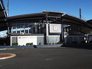
Robina railway station is located on the Gold Coast line in Queensland, Australia. It serves the Gold Coast suburb of Robina.

Helensvale is a suburb of the City of Gold Coast in Queensland, Australia. In the 2016 census, Helensvale had a population of 16,862 people.

Carrara is a suburb in the City of Gold Coast, Queensland, Australia. In the 2016 census, Carrara had a population of 12,060 people.
The M1 in, Queensland, Australia, is a major urban road corridor. It connects the Sunshine Coast hinterland to Tugun, near the New South Wales and Queensland border, via the following corridors:
Varsity Lakes is a suburb in the City of Gold Coast, Queensland, Australia. In the 2021 census, Varsity Lakes had a population of 16,493 people.

The Gold Coast is the largest regional city and fastest growing city in Australia. As a result, the Gold Coast has a wide range of public and private transport options from cars and bikes to buses, heavy rail and light rail. The car is the dominant mode of transport in the city with an extensive arterial road network that connects the standard residential streets with major suburbs and motorways.

Mermaid Waters is a suburb in the City of Gold Coast, Queensland, Australia. In the 2016 census, Mermaid Waters had a population of 12,045 people.

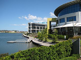
Clear Island Waters is a suburb of the City of Gold Coast in Queensland, Australia. In the 2016 census, Clear Island Waters had a population of 4,120 people.

Gold Coast Highway links the coastal suburbs of the Gold Coast in south eastern Queensland such as Miami, Mermaid Beach, Tugun, Bilinga and across the border of New South Wales to the Tweed Heads suburb of Tweed Heads West. At 39.6 kilometres (24.6 mi) in length, the highway runs just west of Pacific Motorway at Pacific Pines to Pacific Motorway at Tweed Heads West. It passes through the numerous popular tourist areas including Surfers Paradise and Broadbeach, a commercial centre at Southport, residential areas, shopping centres and the Gold Coast (Coolangatta) Airport.
Bermuda Street is a road on the Gold Coast from Bundall to Burleigh Heads in Queensland, Australia. Originally a suburban street, it is now part of Southport – Burleigh Road, a state controlled road
Nerang–Broadbeach Road is a road on the Gold Coast, Queensland, Australia. It is classified a state-controlled district road, and is part of State Route 90. The eastern section is also known as Hooker Boulevard.
Robina Parkway is a major road on the Gold Coast, Queensland. The road begins at the overpass of the Pacific Motorway and travels through the suburb of Robina before termination in Carrara at the intersection with Gooding Drive and Nerang–Broadbeach Road.
Burleigh Connection Road is a major arterial road connecting the Pacific Motorway with the Gold Coast suburb of Burleigh Heads.

Merrimac railway station is a planned railway station on the Gold Coast Line in Queensland, Australia. It will serve the Gold Coast suburbs of Merrimac, Worongary and Carrara, and will be located between Nerang and Robina stations.
The Coomera Connector, formerly known as the Intra Regional Transport Corridor, is a proposed 45-kilometre (28 mi) motorway that will connect Logan City with the Gold Coast in South East Queensland, Australia. It will run parallel to the M1 Pacific Motorway for its entire length and will run adjacent to the Gold Coast railway line south of Coomera.
Ipswich–Boonah–Rathdowney Road is a continuous 87.8 kilometres (54.6 mi) road route in the Ipswich and Scenic Rim regions of Queensland, Australia. It has two official names, Ipswich–Boonah Road and Boonah–Rathdowney Road. The entire route is signed as State Route 93, and much of it is also part of Tourist Drive 16.
Beaudesert–Boonah–Fassifern Road is a non-continuous 49.9 kilometres (31.0 mi) road route in the Scenic Rim region of Queensland, Australia. It has two official names, Beaudesert–Boonah Road and Boonah–Fassifern Road. The route is signed as State Route 90. These roads are joined by a 6.8 kilometres (4.2 mi) section of Ipswich-Boonah Road. Beaudesert–Boonah Road is a state-controlled regional road, and Boonah–Fassifern Road is also a state-controlled regional road. As part of State Route 90 it provides an alternate route between the Cunningham Highway and the Gold Coast.