Palmerston, Queensland

Last updated

Palmerston
Queensland
Australia Queensland location map.svg
Red pog.svg
Palmerston
Coordinates 17°36′35″S145°44′58″E / 17.6097°S 145.7494°E / -17.6097; 145.7494 (Palmerston (centre of locality))
Population8 (SAL 2021) [1]
Postcode(s) 4860
Area94.8 km2 (36.6 sq mi)
Time zone AEST (UTC+10:00)
Location
LGA(s)
State electorate(s) Hill
Federal division(s) Kennedy
Suburbs around Palmerston:
Middlebrook Wooroonooran Wooroonooran
Maalan Palmerston East Palmerston
Koombooloomba Gulngai Mamu

Palmerston is a rural locality split between the Tablelands Region and the Cassowary Coast Region, Queensland, Australia. [2] [3] In the 2021 census, Palmerston had a population of 8 people. [4]

Contents

Geography

Mount Father Clancy is in the north-west of the locality ( 17°35′16″S145°38′03″E / 17.5878°S 145.6343°E / -17.5878; 145.6343 (Mount Father Clancy) ) rising to 1,087 metres (3,566 ft) above sea level. [5] [6] [7]

The locality is entirely within the Wooroonooran National Park, part of the Wet Tropics World Heritage Area . [7] [8]

The South Johnstone River rises in the west of the locality, flows south-west, where it forms part of the southern boundary of the locality and then exits to the south-east (Gulngai). [7]

History

The locality is believed to be named after explorer Christie Palmerston. [2] [3]

Demographics

In the 2016 census, Palmerston had a population of 3 people. [9]

In the 2021 census, Palmerston had a population of 8 people. [4]

Attractions

The Palmerston section of the national park is known for its dense rainforest with over 500 species of trees with opportunities to see many animals including brightly-coloured butterflies. The park offers a number of facilities for visitors including camping grounds, tracks for walking and cycling, swimming holes, and picnic areas. [10]

Related Research Articles

<span class="mw-page-title-main">Cape Tribulation, Queensland</span> Suburb of Shire of Douglas, Queensland, Australia

Cape Tribulation is a headland and coastal locality in the Shire of Douglas in northern Queensland, Australia. In the 2021 census, Cape Tribulation had a population of 123 people.

Beatrice is a rural locality in the Tablelands Region, Queensland, Australia. In the 2021 census, Beatrice had a population of 126 people.

<span class="mw-page-title-main">Lake Barrine, Queensland</span> Suburb of Tablelands Region, Queensland, Australia

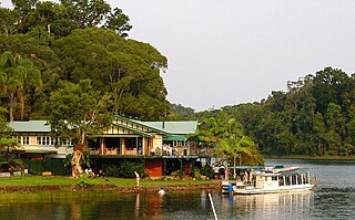
Lake Barrine is a rural locality in the Tablelands Region, Queensland, Australia. In the 2021 census, Lake Barrine had a population of 170 people.

<span class="mw-page-title-main">Upper Barron</span> Suburb of Tablelands Region, Queensland, Australia

Upper Barron is a rural locality in the Tablelands Region, Queensland, Australia. In the 2021 census, Upper Barron had a population of 503 people.

<span class="mw-page-title-main">Goldsborough, Queensland</span> Suburb of Cairns Region, Queensland, Australia

Goldsborough is a locality in the Cairns Region, Queensland, Australia. In the 2021 census, Goldsborough had a population of 1,099 people.

<span class="mw-page-title-main">Wooroonooran, Queensland</span> Suburb of Cairns Region, Queensland, Australia

Wooroonooran is a locality split among the Cairns Region, the Cassowary Coast Region and the Tablelands Region in Queensland, Australia. In the 2016 census, Wooroonooran had no population.

<span class="mw-page-title-main">Ngatjan</span> Suburb of Cassowary Coast Region, Queensland, Australia

Ngatjan is a locality split between the Cassowary Coast Region and the Cairns Region, Queensland, Australia. In the 2016 census, Ngatjan had no population. The term is derived from the ethnonym of the local Ngatjan people.

<span class="mw-page-title-main">Macalister Range, Queensland</span> Suburb of Cairns Region, Queensland, Australia

Macalister Range is a coastal locality in the Cairns Region, Queensland, Australia. In the 2021 census, Macalister Range had a population of 0 people.

<span class="mw-page-title-main">Danbulla, Queensland</span> Suburb of Tablelands Region, Queensland, Australia

Danbulla is a locality in the Tablelands Region, Queensland, Australia. In the 2021 census, Danbulla had a population of 88 people.

Djiru is a coastal locality in the Cassowary Coast Region, Queensland, Australia. In the 2016 census, Djiru had a population of 0 people.

Mount Mackay is a locality in the Cassowary Coast Region, Queensland, Australia. In the 2021 census, Mount Mackay had "no people or a very low population".

<span class="mw-page-title-main">Mamu, Queensland</span> Suburb of Cassowary Coast Region, Queensland, Australia

Mamu is a rural locality in the Cassowary Coast Region, Queensland, Australia. In the 2021 census, Mamu had a population of 0 people.Mamu’s postcode is 4871.

Gulngai is a rural locality in the Cassowary Coast Region, Queensland, Australia. In the 2016 census, Gulngai had a population of 0 people.

Lumholtz is a rural locality in the Cassowary Coast Region, Queensland, Australia. In the 2021 census, Lumholtz had a population of 0 people.

Nerada is a rural locality in the Cassowary Coast Region, Queensland, Australia. In the 2021 census, Nerada had a population of 88 people.

O'Briens Hill is a rural locality in the Cassowary Coast Region, Queensland, Australia. In the 2021 census, O'Briens Hill had a population of 11 people.

Maadi is a rural locality in the Cassowary Coast Region, Queensland, Australia. In the 2021 census, Maadi had a population of 49 people.

Kooroomool is a rural locality in the Cassowary Coast Region, Queensland, Australia. In the 2016 census, Kooroomool had a population of 0 people.

Shell Pocket is a rural locality in the Cassowary Coast Region, Queensland, Australia. In the 2021 census, Shell Pocket had a population of 83 people.

<span class="mw-page-title-main">Middlebrook, Queensland</span> Suburb of Tablelands Region, Queensland, Australia

Middlebrook is a rural locality in the Tablelands Region, Queensland, Australia. In the 2021 census, Middlebrook had a population of 62 people.

References

  1. Australian Bureau of Statistics (28 June 2022). "Palmerston (Qld) (suburb and locality)". Australian Census 2021 QuickStats. Retrieved 28 June 2022.  OOjs UI icon edit-ltr-progressive.svg
  2. 1 2 "Palmerston – locality in Tablelands Region (entry 48825)". Queensland Place Names. Queensland Government . Retrieved 31 October 2019.
  3. 1 2 "Palmerston – locality in Cassowary Coast Region (entry 45748)". Queensland Place Names. Queensland Government . Retrieved 29 October 2019.
  4. 1 2 Australian Bureau of Statistics (28 June 2022). "Palmerston (SAL)". 2021 Census QuickStats. Retrieved 28 February 2023. OOjs UI icon edit-ltr-progressive.svg
  5. "Mountain peaks and capes - Queensland". Queensland Open Data. Queensland Government. 12 November 2020. Archived from the original on 25 November 2020. Retrieved 25 November 2020.
  6. "Mount Father Clancy – mountain in Tablelands Region (entry 12250)". Queensland Place Names. Queensland Government . Retrieved 25 November 2020.
  7. 1 2 3 "Queensland Globe". State of Queensland . Retrieved 26 December 2023.
  8. "Wet Tropics parks". Parks and Forests. Queensland Government. Archived from the original on 26 October 2021. Retrieved 26 December 2023.
  9. Australian Bureau of Statistics (27 June 2017). "Palmerston (SSC)". 2016 Census QuickStats. Retrieved 20 October 2018. OOjs UI icon edit-ltr-progressive.svg
  10. "Things to do | Palmerston (Doongan), Wooroonooran National Park". Parks and forests. Queensland Government. 20 October 2009. Archived from the original on 4 November 2023. Retrieved 26 December 2023.