Cullinane, Queensland

Last updated

Cullinane
Queensland
Australia Queensland location map.svg
Red pog.svg
Cullinane
Coordinates 17°30′46″S146°01′17″E / 17.5127°S 146.0213°E / -17.5127; 146.0213 (Cullinane (centre of locality)) Coordinates: 17°30′46″S146°01′17″E / 17.5127°S 146.0213°E / -17.5127; 146.0213 (Cullinane (centre of locality))
Population524 (2016 census) [1]
 • Density308/km2 (798/sq mi)
Postcode(s) 4860
Area1.7 km2 (0.7 sq mi)
Time zone AEST (UTC+10:00)
Location
LGA(s) Cassowary Coast Region
State electorate(s) Hill
Federal Division(s) Kennedy
Suburbs around Cullinane:
Goondi Sundown Innisfail Estate
Goondi Bend Cullinane Innisfail Estate
Goondi Hill Innisfail Innisfail Estate

Cullinane is a rural locality in the Cassowary Coast Region, Queensland, Australia. [2] In the 2016 census, Cullinane had a population of 524 people. [1]

Contents

Geography

Cullinane is bounded by the North Coast railway line to the west, See Poy Road to the north, Johnstone River to the east and Campbell Street to the south-east. [3]

The land is flat and below 10 metres (33 ft) above sea level. There is some suburban housing in the east of the suburb but the remainder of the suburb is used for agriculture, predominantly sugarcane farming. [4]

History

The locality name was adopted in August 1996. It was proposed by the Johnstone Shire Council, after pioneer farmer Michael Cullinane. [2]

In the 2016 census, Cullinane had a population of 524 people. [1]

Education

There are no schools in Cullinane. The nearest primary school is Innisfail State School in neighbouring Innisfail to the south. The nearest secondary school is Innisfail State College in Innisfail Estate across the river to the east. There are Catholic primary and secondary schools in Innisfail. [4]

Related Research Articles

Innisfail, Queensland Town in Queensland, Australia

Innisfail is a rural town and locality in the Cassowary Coast Region, Queensland, Australia. The town was originally called Geraldton until 1910. In the 2016 census, the town of Innisfail had a population of 7,236 people, while the locality of Innisfail had a population of 1,145 people.

Mission Beach, Queensland Town in Queensland, Australia

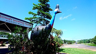
Mission Beach is a small coastal town and locality in the Cassowary Coast Region, Queensland, Australia. In the 2016 census Mission Beach and surrounding villages had a total population of 3,597 people.

Mundoo, Queensland Town in Queensland, Australia

Mundoo is a town and locality in the Cassowary Coast Region, Queensland, Australia.

East Innisfail, Queensland Suburb of Cassowary Coast Region, Queensland, Australia

East Innisfail is a suburban locality in the Cassowary Coast Region, Queensland, Australia. In the 2016 census, East Innisfail had a population of 1,855 people.

South Johnstone, Queensland Town in Queensland, Australia

South Johnstone is a rural town and locality in the Cassowary Coast Region, Queensland, Australia. In the 2016 census, South Johnstone had a population of 413 people.

Mourilyan Harbour Suburb of Cassowary Coast Region, Queensland, Australia

Mourilyan Harbour is a coastal locality and harbour within the Cassowary Coast Region, Queensland, Australia. In the 2016 census, Mourilyan Harbour had a population of 156 people.

Flying Fish Point, Queensland Town in Queensland, Australia

Flying Fish Point is a coastal town, locality and headland in the Cassowary Coast Region, Queensland, Australia. In the 2016 census, Flying Fish Point had a population of 425 people.

Feluga, Queensland Suburb of Cassowary Coast Region, Queensland, Australia

Feluga is a locality in the Cassowary Coast Region, Queensland, Australia.

Eubenangee, Queensland Suburb of Cairns Region, Queensland, Australia

Eubenangee is a coastal locality split between the Cairns Region and the Cassowary Coast Region, Queensland, Australia. In the 2016 census, the population of Eubenangee was 242 people.

Coorumba, Queensland Suburb of Cassowary Coast Region, Queensland, Australia

Coorumba is a rural locality in the Cassowary Coast Region, Queensland, Australia. In the 2016 census, Coorumba had a population of 121 people.

Daradgee, Queensland Town in Queensland, Australia

Daradgee is a rural town and locality in the Cassowary Coast Region, Queensland, Australia. In the 2016 census, Daradgee had a population of 74 people.

Wongaling Beach, Queensland Town in Queensland, Australia

Wongaling Beach is a tropical beachside coastal town and locality in the Cassowary Coast Region, Queensland, Australia. In the 2016 census Wongaling Beach had a population of 1,245, making it the most populated suburb in the town of Mission Beach.

New Harbourline Suburb of Cassowary Coast Region, Queensland, Australia

New Harbourline is a locality in the Cassowary Coast Region, Queensland, Australia. In the 2016 census, New Harbourline had a population of 198 people.

Coquette Point, Queensland Suburb of Cassowary Coast Region, Queensland, Australia

Coquette Point is a coastal locality in the Cassowary Coast Region, Queensland, Australia. In the 2016 census, Coquette Point had a population of 74 people.

Bombeeta, Queensland Suburb of Cassowary Coast Region, Queensland, Australia

Bombeeta is a rural locality in the Cassowary Coast Region, Queensland, Australia. In the 2016 census, Bombeeta had a population of 136 people.

Mighell, Queensland Suburb of Cassowary Coast Region, Queensland, Australia

Mighell is a rural locality in the Cassowary Coast Region, Queensland, Australia. In the 2016 census, Mighell had a population of 380 people.

Goondi Hill, Queensland Suburb of Cassowary Coast Region, Queensland, Australia

Goondi Hill is a semi-urban locality in the Cassowary Coast Region, Queensland, Australia. In the 2016 census, Goondi Hill had a population of 510 people.

Innisfail Estate, Queensland Suburb of Cassowary Coast Region, Queensland, Australia

Innisfail Estate is a rural locality in the Cassowary Coast Region, Queensland, Australia. In the 2016 census, Innisfail Estate had a population of 1,338 people.

Upper Daradgee, Queensland Suburb of Cassowary Coast Region, Queensland, Australia

Upper Daradgee is a rural locality in the Cassowary Coast Region, Queensland, Australia. In the 2016 census, Upper Daradgee had a population of 101 people.

Sundown, Queensland (Cassowary Coast Region) Suburb of Cassowary Coast Region, Queensland, Australia

Sundown is a rural locality in the Cassowary Coast Region, Queensland, Australia. In the 2016 census, Sundown had a population of 178 people.

References

  1. 1 2 3 Australian Bureau of Statistics (27 June 2017). "Cullinane (SSC)". 2016 Census QuickStats. Retrieved 20 October 2018. OOjs UI icon edit-ltr-progressive.svg
  2. 1 2 "Cullinane - locality in Cassowary Coast Region (entry 45690)". Queensland Place Names. Queensland Government . Retrieved 18 September 2020.
  3. "Queensland Globe". State of Queensland . Retrieved 1 October 2020.
  4. 1 2 "Queensland Globe". State of Queensland . Retrieved 1 October 2020.