
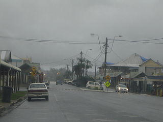
Tully is a rural town and locality in the Cassowary Coast Region, Queensland, Australia. It is adjacent to the Bruce Highway, approximately 140 kilometres (87 mi) south of Cairns by road and 210 kilometres (130 mi) north of Townsville. Tully is perhaps best known for being one of the wettest towns in Australia, and home to the 7.9 m tall Golden Gumboot.
Babinda is a rural town and locality in the Cairns Region, Queensland, Australia. Babinda and Tully annually compete for the Golden Gumboot, an award for Australia's wettest town. Babinda is usually the winner, recording an annual average rainfall of over 4,279.4 millimetres (168.48 in) each year. In the 2021 census, the locality of Babinda had a population of 1,287 people.
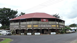
El Arish is a rural town and locality in the Cassowary Coast Region, Queensland, Australia. In the 2021 census, the locality of El Arish had a population of 337 people.

Kennedy is a coastal locality in the Cassowary Coast Region, Queensland, Australia. In the 2021 census, Kennedy had a population of 136 people.

Feluga is a rural locality in the Cassowary Coast Region, Queensland, Australia. In the 2021 census, Feluga had a population of 306 people.

Lower Tully is a rural locality in the Cassowary Coast Region, Queensland, Australia. In the 2021 census, Lower Tully had a population of 88 people.

Wrights Creek is a rural locality in the Cairns Region, Queensland, Australia. In the 2021 census, Wrights Creek had a population of 160 people.

Euramo is a rural locality in the Cassowary Coast Region, Queensland, Australia. In the 2021 census, Euramo had a population of 114 people.
Japoonvale is a rural locality in the Cassowary Coast Region, Queensland, Australia. In the 2021 census, Japoonvale had a population of 107 people.

Ellerbeck is a coastal locality in the Cassowary Coast Region, Queensland, Australia. In the 2021 census, Ellerbeck had a population of 207 people.
Bilyana is a coastal locality in the Cassowary Coast Region, Queensland, Australia. In the 2021 census, Bilyana had a population of 190 people.
Nahrunda is a rural locality in the Gympie Region, Queensland, Australia. In the 2021 census, Nahrunda had a population of 192 people.
Mighell is a rural locality in the Cassowary Coast Region, Queensland, Australia. In the 2021 census, Mighell had a population of 363 people.
Goolboo is a rural locality in the Cassowary Coast Region of Queensland, Australia. In the 2021 census, Goolboo had a population of 25 people.
Pin Gin Hill is a rural locality in the Cassowary Coast Region, Queensland, Australia. In the 2021 census, Pin Gin Hill had a population of 191 people.
Jaffa is a rural locality in the Cassowary Coast Region, Queensland, Australia. In the 2021 census, Jaffa had a population of 35 people.
Djarawong is a rural locality in the Cassowary Coast Region, Queensland, Australia. In the 2021 census, Djarawong had a population of 103 people.
Maadi is a rural locality in the Cassowary Coast Region, Queensland, Australia. In the 2021 census, Maadi had a population of 49 people.
Maria Creeks is a rural locality in the Cassowary Coast Region, Queensland, Australia. In the 2021 census, Maria Creeks had a population of 143 people.

Murrigal is a rural locality in the Cassowary Coast Region, Queensland, Australia. In the 2021 census, Murrigal had a population of 106 people.

