Midgenoo, Queensland

Last updated

Midgenoo
Queensland
Midgenoo QLD 4854, Australia - panoramio.jpg
View across the fields to distant mountains, Midgenoo, 2013
Australia Queensland location map.svg
Red pog.svg
Midgenoo
Coordinates 17°53′41″S145°57′38″E / 17.8947°S 145.9605°E / -17.8947; 145.9605 (Midgenoo (town centre))
Population76 (2021 census) [1]
 • Density10.13/km2 (26.2/sq mi)
Postcode(s) 4854
Area7.5 km2 (2.9 sq mi)
Time zone AEST (UTC+10:00)
Location
LGA(s) Cassowary Coast Region
State electorate(s) Hill
Federal division(s) Kennedy
Localities around Midgenoo:
Feluga Feluga East Feluga
Bulgun Midgenoo East Feluga
Birkalla Birkalla Merryburn

Midgenoo is a rural town and locality in the Cassowary Coast Region, Queensland, Australia. [2] [3] In the 2021 census, the locality of Midgenoo had a population of 76 people. [1]

Contents

Geography

The town is north of centre within the locality. This land is flat (approx 20 metres above sea level) and is used for crops, principally sugarcane. [4]

The Bruce Highway and North Coast railway line traverse the locality from south-west to north, passing through the town. [4] Midgenoo railway station ( 17°53′44″S145°57′40″E / 17.8955°S 145.9611°E / -17.8955; 145.9611 (Midgenoo railway station) ) once served the town but now is abandoned. [5] [6] There are also sugarcane tramways in the locality. [4]

History

Aboriginal stockmen Digby Denham and Old Mango at Midgenoo, 1916 Aboriginal stockmen Digby Denham and Old Mango at Midgenoo 1916 (17239414382).jpg
Aboriginal stockmen Digby Denham and Old Mango at Midgenoo, 1916

The town's name Midgenoo is taken from the Midgenoo railway station and is reportedly an Aboriginal word for a local tree. [2]

Midgenoo State School opened in 1923 and closed in 1933. [7]

Demographics

In the 2016 census, the locality of Midgenoo had a population of 51 people. [8]

In the 2021 census, the locality of Midgenoo had a population of 76 people. [1]

Education

There are no schools in Midgneoo. The nearest government primary school is Feluga State School in neighbouring Feluga to the north. The nearest government secondary school is Tully State High School in Tully to the south. There is also a Catholic primary school in Tully. [9]

Related Research Articles

<span class="mw-page-title-main">Garradunga</span> Suburb of Cassowary Coast Region, Queensland, Australia

Garradunga is a rural locality in the Cassowary Coast Region, Queensland, Australia. In the 2021 census, Garradunga had a population of 170 people.

<span class="mw-page-title-main">Kennedy, Queensland</span> Suburb of Cassowary Coast Region, Queensland, Australia

Kennedy is a coastal locality in the Cassowary Coast Region, Queensland, Australia. In the 2021 census, Kennedy had a population of 136 people.

Moresby is a rural town and locality in the Cassowary Coast Region, Queensland, Australia. In the 2021 census, the locality of Moresby had a population of 150 people.

<span class="mw-page-title-main">Feluga, Queensland</span> Suburb of Cassowary Coast Region, Queensland, Australia

Feluga is a rural locality in the Cassowary Coast Region, Queensland, Australia. In the 2021 census, Feluga had a population of 306 people.

<span class="mw-page-title-main">Eubenangee, Queensland</span> Suburb of Cairns Region, Queensland, Australia

Eubenangee is a coastal locality split between the Cairns Region and the Cassowary Coast Region, Queensland, Australia. In the 2021 census, Eubenangee had a population of 247 people.

<span class="mw-page-title-main">Euramo, Queensland</span> Suburb of Cassowary Coast Region, Queensland, Australia

Euramo is a rural locality in the Cassowary Coast Region, Queensland, Australia. In the 2021 census, Euramo had a population of 114 people.

<span class="mw-page-title-main">Silky Oak, Queensland</span> Suburb of Cassowary Coast Region, Queensland, Australia

Silky Oak is a rural locality in the Cassowary Coast Region, Queensland, Australia. In the 2021 census, Silky Oak had a population of 178 people.

<span class="mw-page-title-main">Ellerbeck, Queensland</span> Suburb of Cassowary Coast Region, Queensland, Australia

Ellerbeck is a coastal locality in the Cassowary Coast Region, Queensland, Australia. In the 2021 census, Ellerbeck had a population of 207 people.

Bilyana is a coastal locality in the Cassowary Coast Region, Queensland, Australia. In the 2021 census, Bilyana had a population of 190 people.

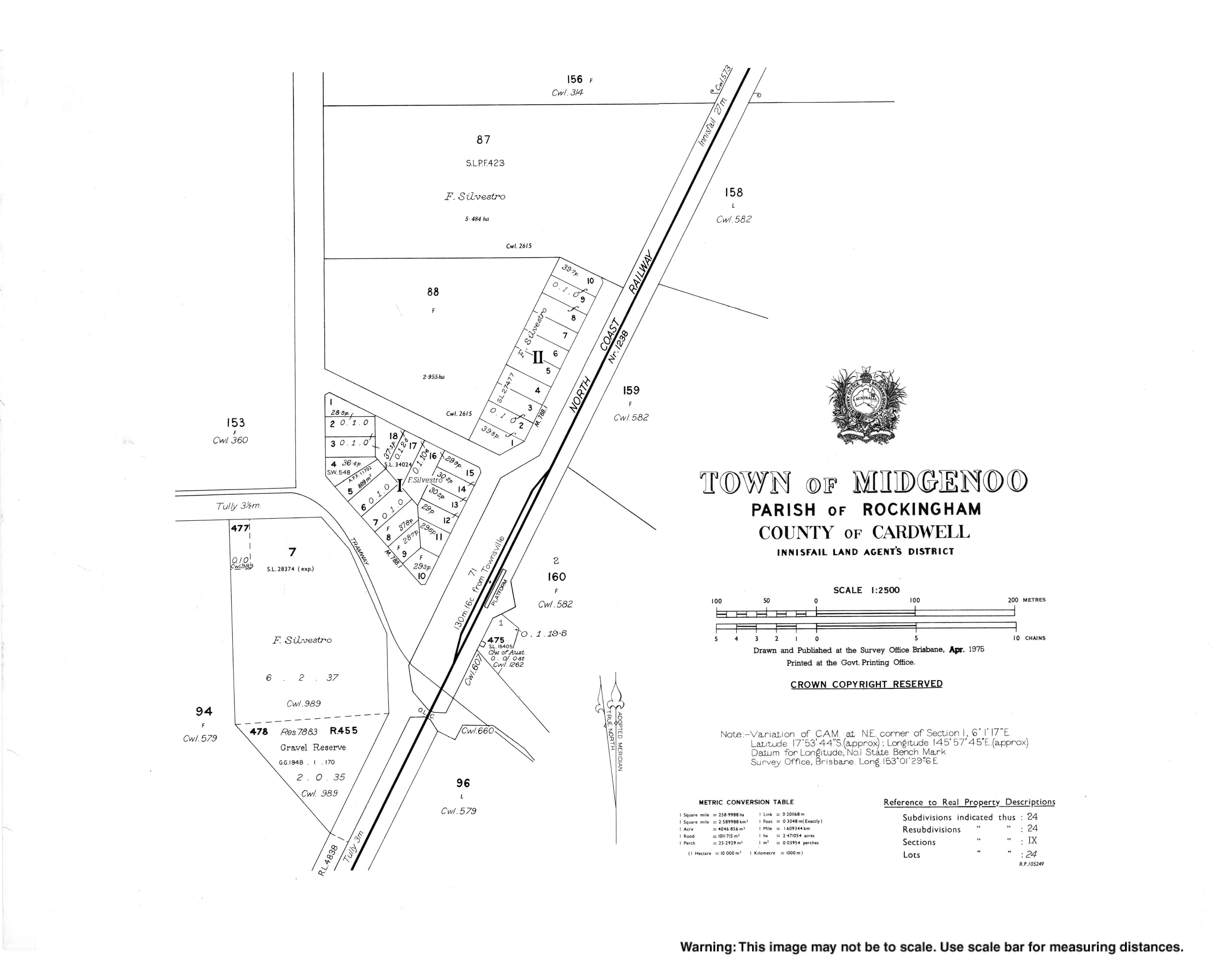
Rockingham is a rural town and coastal locality in the Cassowary Coast Region, Queensland, Australia. In the 2021 census, the locality of Rockingham had a population of 104 people.

Birkalla is a rural locality in the Cassowary Coast Region, Queensland, Australia. In the 2021 census, Birkalla had a population of 156 people.

Bulgun is a rural locality in the Cassowary Coast Region, Queensland, Australia. In the 2021 census, Bulgun had a population of 285 people.

Goolboo is a rural locality in the Cassowary Coast Region of Queensland, Australia. In the 2021 census, Goolboo had a population of 25 people.

Pin Gin Hill is a rural locality in the Cassowary Coast Region, Queensland, Australia. In the 2021 census, Pin Gin Hill had a population of 191 people.

Jaffa is a rural locality in the Cassowary Coast Region, Queensland, Australia. In the 2021 census, Jaffa had a population of 35 people.

Djarawong is a rural locality in the Cassowary Coast Region, Queensland, Australia. In the 2021 census, Djarawong had a population of 103 people.

Maadi is a rural locality in the Cassowary Coast Region, Queensland, Australia. In the 2021 census, Maadi had a population of 49 people.

East Feluga is a rural locality in the Cassowary Coast Region, Queensland, Australia. In the 2021 census, East Feluga had a population of 266 people.

Merryburn is a rural locality in the Cassowary Coast Region, Queensland, Australia. In the 2021 census, Merryburn had a population of 189 people.

<span class="mw-page-title-main">Murrigal, Queensland</span> Suburb of Cassowary Coast Region, Queensland, Australia

Murrigal is a rural locality in the Cassowary Coast Region, Queensland, Australia. In the 2021 census, Murrigal had a population of 106 people.

References

  1. 1 2 3 Australian Bureau of Statistics (28 June 2022). "Midgenoo (SAL)". 2021 Census QuickStats. Retrieved 28 February 2023. OOjs UI icon edit-ltr-progressive.svg
  2. 1 2 "Midgenoo – town in Cassowary Coast Region (entry 22010)". Queensland Place Names. Queensland Government . Retrieved 26 December 2020.
  3. "Midgenoo – locality in Cassowary Coast Region (entry 45730)". Queensland Place Names. Queensland Government . Retrieved 26 December 2020.
  4. 1 2 3 "Queensland Globe". State of Queensland . Retrieved 30 July 2017.
  5. "Midgenoo – railway station in Cassowary Coast Region (entry 22011)". Queensland Place Names. Queensland Government . Retrieved 30 July 2017.
  6. "Railway stations and sidings - Queensland". Queensland Open Data. Queensland Government. 2 October 2020. Archived from the original on 5 October 2020. Retrieved 5 October 2020.
  7. Queensland Family History Society (2010), Queensland schools past and present (Version 1.01 ed.), Queensland Family History Society, ISBN   978-1-921171-26-0
  8. Australian Bureau of Statistics (27 June 2017). "Midgenoo (SSC)". 2016 Census QuickStats. Retrieved 20 October 2018. OOjs UI icon edit-ltr-progressive.svg
  9. "Layers: Locality; Schools and school catchments". Queensland Globe. Queensland Government. Archived from the original on 19 December 2017. Retrieved 21 December 2024.