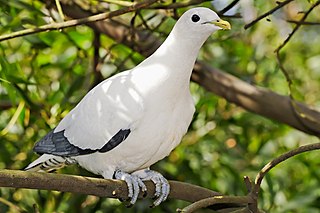
The Brook Islands National Park is a national park in Cassowary Coast Region, Queensland, Australia, 1246 km northwest of Brisbane, with an area of 0.9 km2. It was established in 1994 and comprises three islands which lie off the coast 7 km north-east of Cape Richards on Hinchinbrook Island and 30 km east of the nearest mainland town of Cardwell. The fourth island of the Brooks group, South Island, is not part of the national park but is protected by the Great Barrier Reef Marine Park Authority. Public access to the three islands in the national park is prohibited in order to protect breeding birds, especially the Torresian imperial-pigeon. The islands have no roads, walking tracks or other facilities. Popular activities in the waters around the islands are boating, snorkelling and fishing. The islands are managed by the Queensland Parks and Wildlife Service. The Park's IUCN category is II.

Goold Island is a national park in Queensland, Australia, 1,250 km (780 mi) northwest of Brisbane. The island is close to the northern tip of Hinchinbrook Island off the coast from Cardwell in Rockingham Bay and is part of the Great Barrier Reef World Heritage Area.
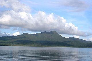
Hinchinbrook Island National Park is Australia's largest island national park. It is situated along the Cassowary Coast Queensland, Australia. The nearest capital city is Brisbane approximately 1,240 km to the south. Lucinda is 135 km or 1.5 hours drive north of Townsville being the closest North Queensland provincial city. Cairns a Far North Queensland provincial city is two and a half to 3 hours drive north from Cardwell. The main geographical features in the park are the rugged Hinchinbrook Island, including Mount Bowen, The Thumb, Mount Diamantina and Mount Straloch.

Hinchinbrook Island is an island in the Cassowary Coast Region, Queensland, Australia. It lies east of Cardwell and north of Lucinda, separated from the north-eastern coast of Queensland by the narrow Hinchinbrook Channel. Hinchinbrook Island is part of the Great Barrier Reef Marine Park and wholly protected within the Hinchinbrook Island National Park, except for a small and abandoned resort. It is the largest island on the Great Barrier Reef. It is also the largest island national park in Australia.
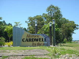
Cardwell is a coastal town and rural locality in the Cassowary Coast Region, Queensland, Australia. In the 2016 census, the locality of Cardwell had a population of 1,309 people.

Cowley Beach is a beach, coastal town and locality in the Cassowary Coast Region, Queensland, Australia. In the 2021 census, the locality of Cowley Beach had a population of 65 people.
Damper Creek is a coastal locality in the Cassowary Coast Region, Queensland, Australia. In the 2021 census, Damper Creek had a population of 34 people.

Murray Upper is a rural locality in the Cassowary Coast Region, Queensland, Australia. In the 2016 census Murray Upper had a population of 266 people.

Ngatjan is a locality split between the Cassowary Coast Region and the Cairns Region, Queensland, Australia. In the 2016 census, Ngatjan had no population. The term is derived from the ethnonym of the local Ngatjan people.
Rungoo is a coastal locality in the Cassowary Coast Region, Queensland, Australia. In the 2021 census, Rungoo had a population of 11 people.
Bilyana is a coastal locality in the Cassowary Coast Region, Queensland, Australia. In the 2021 census, Bilyana had a population of 190 people.
Tam O'Shanter is a rural locality in the Cassowary Coast Region, Queensland, Australia. In the 2021 census, Tam O'Shanter had "no people or a very low population".
Mount Mackay is a locality in the Cassowary Coast Region, Queensland, Australia. In the 2021 census, Mount Mackay had "no people or a very low population".

Mamu is a rural locality in the Cassowary Coast Region, Queensland, Australia. In the 2021 census, Mamu had a population of 0 people.Mamu’s postcode is 4871.
Gulngai is a rural locality in the Cassowary Coast Region, Queensland, Australia. In the 2021 census, Gulngai had "no people or a very low population".
Lumholtz is a rural locality in the Cassowary Coast Region, Queensland, Australia. In the 2021 census, Lumholtz had a population of 0 people.
Walter Hill is a rural locality in the Cassowary Coast Region, Queensland, Australia. In the 2016 census, Walter Hill had a population of 0 people.
Maadi is a rural locality in the Cassowary Coast Region, Queensland, Australia. In the 2021 census, Maadi had a population of 49 people.
Kooroomool is a rural locality in the Cassowary Coast Region, Queensland, Australia. In the 2021 census, Kooroomool had "no people or a very low population".
Palmerston is a rural locality split between the Tablelands Region and the Cassowary Coast Region, Queensland, Australia. In the 2021 census, Palmerston had a population of 8 people.

