Ellerbeck, Queensland

Last updated

Ellerbeck
Queensland
Ellerbeck QLD 4816, Australia - panoramio (1).jpg
Meunga Creek, Ellerbeck
Australia Queensland location map.svg
Red pog.svg
Ellerbeck
Coordinates 18°14′28″S145°59′39″E / 18.2411°S 145.9941°E / -18.2411; 145.9941 (Ellerbeck (centre of locality))
Population207 (2021 census) [1]
 • Density7.238/km2 (18.75/sq mi)
Postcode(s) 4816
Area28.6 km2 (11.0 sq mi)
Time zone AEST (UTC+10:00)
Location
LGA(s) Cassowary Coast Region
State electorate(s) Hinchinbrook
Federal division(s) Kennedy
Suburbs around Ellerbeck:
Kennedy Kennedy Kennedy
Kennedy Ellerbeck Coral Sea
Carruchan Cardwell Cardwell

Ellerbeck is a coastal locality in the Cassowary Coast Region, Queensland, Australia. [2] In the 2021 census, Ellerbeck had a population of 207 people. [1]

Contents

Geography

The locality is bounded to the south by Attie Creek, a tributary of Meunga Creek which forms the south-western boundary of the locality and then flows east through the locality to the Coral Sea ( 18°13′53″S146°00′53″E / 18.23139°S 146.01472°E / -18.23139; 146.01472 (Meunga Creek (mouth)) ). [3] [4]

The Bruce Highway enters the locality from the south-east (Cardwell) and exits to the north-west (Kennedy). [4]

The North Coast railway line also enters the locality from the south-east (Cardwell) and exits to the north-west (Kennedy). [4] The locality was served by the now-abandoned Ellerbeck railway station ( 18°14′34″S145°59′36″E / 18.2428°S 145.9933°E / -18.2428; 145.9933 (Ellerbeck railway station (former)) ). [5]

Part of the eastern coastal of the locality is within the Girramay National Park. Apart from this protected area, the remainder of the locality is mixture of agricultural use (crop growing and grazing on native vegetation) and rural residential housing. [4]

History

The locality was named after the Ellerbeck railway station, which was in turn named on 18 February 1925 by the Queensland Railways Department. [2]

The name for the parish has been documented since 1866. As for the locality, the name of the town of Ellerbeck near Osnabrück was probably the basis. Though, however, can be seen as a Germanic language name, Ellerbeck is therefore found in England or North Germany. [6]

Demographics

In the 2016 census, Ellerbeck had a population of 205 people. [7]

In the 2021 census, Ellerbeck had a population of 207 people. [1]

Education

There are no schools in Ellerbeck. The nearest government primary schools are Cardwell State School in neighbouring Cardwell to the south-east and Kennedy State School in neighbouring Kennedy to the north-west. The nearest government secondary school is Tully State High School in Tully to the north. [4]

Facilities

There is a boat ramp on Meunga Creek Boat Ramp Road on the south bank of Meunga Creek ( 18°13′55″S146°00′52″E / 18.2320°S 146.0145°E / -18.2320; 146.0145 (Meunga Creek Boat Ramp Road boat ramp) ). It is managed by the Cassowary Coast Regional Council. [8]

Cardwell Waste Transfer Station on Lawson Drive accepts waste for both recycling and landfill ( 18°14′42″S146°00′31″E / 18.2451°S 146.0087°E / -18.2451; 146.0087 (Cardwell Waste Transfer Station) ). [9] [10]

Climate

The climate of Ellerbek is classified as tropical monsoon climate (Köppen Am).

Climate data for Ellerbeck
MonthJanFebMarAprMayJunJulAugSepOctNovDecYear
Mean daily maximum °F (°C)89.6
(32.0)
87.8
(31.0)
87.8
(31.0)
84.2
(29.0)
80.6
(27.0)
77.0
(25.0)
77.0
(25.0)
78.8
(26.0)
82.4
(28.0)
84.2
(29.0)
86.0
(30.0)
87.8
(31.0)
83.6
(28.7)
Daily mean °F (°C)82.4
(28.0)
81.5
(27.5)
80.6
(27.0)
77.0
(25.0)
73.4
(23.0)
68.9
(20.5)
68.0
(20.0)
68.9
(20.5)
72.5
(22.5)
76.1
(24.5)
78.8
(26.0)
80.6
(27.0)
75.7
(24.3)
Mean daily minimum °F (°C)75.2
(24.0)
75.2
(24.0)
73.4
(23.0)
69.8
(21.0)
66.2
(19.0)
60.8
(16.0)
59.0
(15.0)
59.0
(15.0)
62.6
(17.0)
68.0
(20.0)
71.6
(22.0)
73.4
(23.0)
67.9
(19.9)
Average rainfall inches (mm)16.16
(410.4)
18.59
(472.3)
14.96
(380.1)
7.82
(198.6)
3.85
(97.9)
1.50
(38.1)
1.26
(31.9)
1.04
(26.5)
1.74
(44.3)
2.44
(62.1)
5.23
(132.8)
8.36
(212.3)
82.95
(2,107.3)
Average precipitation days14151513954345810105
Source: NOAA over google search [11]

Related Research Articles

<span class="mw-page-title-main">Cardwell, Queensland</span> Town in Queensland, Australia

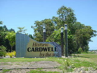
Cardwell is a coastal town and rural locality in the Cassowary Coast Region, Queensland, Australia. In the 2016 census, the locality of Cardwell had a population of 1,309 people.

<span class="mw-page-title-main">Railway Estate, Queensland</span> Suburb of Townsville, Queensland, Australia

Railway Estate is a suburb of Townsville in the City of Townsville, Queensland, Australia. In the 2016 census Railway Estate had a population of 2,852 people.

<span class="mw-page-title-main">Bluewater, Queensland</span> Town in Queensland, Australia

Bluewater is a town and coastal suburb in the City of Townsville, Queensland, Australia. In the 2016 census the suburb of Bluewater had a population of 1,040 people.

<span class="mw-page-title-main">El Arish, Queensland</span> Town in Queensland, Australia

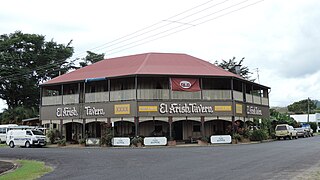
El Arish is a rural town and locality in the Cassowary Coast Region, Queensland, Australia. In the 2016 census, the locality of El Arish had a population of 344 people.

<span class="mw-page-title-main">Rollingstone, Queensland</span> Town in Queensland, Australia

Rollingstone is a rural town and coastal locality in the City of Townsville, Queensland, Australia. In the 2016 census, the locality of Rollingstone had a population of 125 people.

<span class="mw-page-title-main">Nome, Queensland</span> Suburb of City of Townsville, Queensland, Australia

Nome is a rural locality in the City of Townsville, Queensland, Australia. In the 2016 census, Nome had a population of 1,016 people.

<span class="mw-page-title-main">Cowley Beach, Queensland</span> Town in Queensland, Australia

Cowley Beach is a beach, coastal town and locality in the Cassowary Coast Region, Queensland, Australia. In the 2021 census, the locality of Cowley Beach had a population of 65 people.

<span class="mw-page-title-main">Kennedy, Queensland</span> Suburb of Cassowary Coast Region, Queensland, Australia

Kennedy is a coastal locality in the Cassowary Coast Region, Queensland, Australia. In the 2021 census, Kennedy had a population of 136 people.

<span class="mw-page-title-main">Daradgee, Queensland</span> Town in Queensland, Australia

Daradgee is a rural town and locality in the Cassowary Coast Region, Queensland, Australia. In the 2016 census, Daradgee had a population of 74 people.

<span class="mw-page-title-main">Bemerside, Queensland</span> Suburb of Shire of Hinchinbrook, Queensland, Australia

Bemerside is a rural locality in the Shire of Hinchinbrook, Queensland, Australia. In the 2021 census, Bemerside had a population of 259 people.

<span class="mw-page-title-main">Euramo, Queensland</span> Suburb of Cassowary Coast Region, Queensland, Australia

Euramo is a rural locality in the Cassowary Coast Region, Queensland, Australia. In the 2021 census, Euramo had a population of 114 people.

<span class="mw-page-title-main">South Mission Beach</span> Town in Queensland, Australia

South Mission Beach is a coastal town and locality in the Cassowary Coast Region, Queensland, Australia. In the 2021 census, the locality of South Mission Beach had a population of 968 people.

Wangan is a town and a locality in the Cassowary Coast Region, Queensland, Australia. In the 2021 census, the locality of Wangan had a population of 612 people.

Rungoo is a coastal locality in the Cassowary Coast Region, Queensland, Australia. In the 2021 census, Rungoo had a population of 11 people.

Bilyana is a coastal locality in the Cassowary Coast Region, Queensland, Australia. In the 2021 census, Bilyana had a population of 190 people.

<span class="mw-page-title-main">Tully Heads, Queensland</span> Town in Queensland, Australia

Tully Heads is a coastal town and locality in the Cassowary Coast Region, Queensland, Australia. In the 2016 census, the locality of Tully Heads had a population of 354 people.

Mighell is a rural locality in the Cassowary Coast Region, Queensland, Australia. In the 2021 census, Mighell had a population of 363 people.

Goondi Hill is a semi-urban locality in the Cassowary Coast Region, Queensland, Australia. In the 2021 census, Goondi Hill had a population of 437 people.

Jaffa is a rural locality in the Cassowary Coast Region, Queensland, Australia. In the 2021 census, Jaffa had a population of 35 people.

Maadi is a rural locality in the Cassowary Coast Region, Queensland, Australia. In the 2021 census, Maadi had a population of 49 people.

References

  1. 1 2 3 Australian Bureau of Statistics (28 June 2022). "Ellerbeck (SAL)". 2021 Census QuickStats. Retrieved 28 February 2023. OOjs UI icon edit-ltr-progressive.svg
  2. 1 2 "Ellerbeck – locality in Cassowary Coast Region (entry 45671)". Queensland Place Names. Queensland Government . Retrieved 24 May 2019.
  3. "Meunga Creek – watercourse in the Cassowary Coast Region (entry 21727)". Queensland Place Names. Queensland Government . Retrieved 6 September 2023.
  4. 1 2 3 4 5 "Queensland Globe". State of Queensland . Retrieved 6 September 2023.
  5. "Railway stations and sidings - Queensland". Queensland Open Data. Queensland Government. 2 October 2020. Archived from the original on 5 October 2020. Retrieved 5 October 2020.
  6. "Fleischfresser, Freitag, Gramzow, Hebel, Heidelberg, Humboldt in Australien | onomastik.com". www.onomastik.com. Archived from the original on 17 February 2022. Retrieved 28 June 2022.
  7. Australian Bureau of Statistics (27 June 2017). "Ellerbeck (SSC)". 2016 Census QuickStats. Retrieved 20 October 2018. OOjs UI icon edit-ltr-progressive.svg
  8. "Recreational Boating Facilities Queensland". Queensland Open Data. Queensland Government. 12 November 2020. Archived from the original on 22 November 2020. Retrieved 22 November 2020.
  9. "Building points - Queensland". Queensland Open Data. Queensland Government. 17 November 2020. Archived from the original on 25 November 2020. Retrieved 25 November 2020.
  10. "Bells Creek and Cardwell Waste Transfer Stations". Cassowary Coast Regional Council. Archived from the original on 17 March 2023. Retrieved 6 September 2023.
  11. "National Centers for Environmental Information (NCEI)". www.ncei.noaa.gov. Archived from the original on 1 May 2021. Retrieved 21 February 2022.