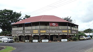
El Arish is a rural town and locality in the Cassowary Coast Region, Queensland, Australia. In the 2016 census, the locality of El Arish had a population of 344 people.

South Johnstone is a rural town and locality in the Cassowary Coast Region, Queensland, Australia. In the 2021 census, the locality of South Johnstone had a population of 456 people.
Bridges is a rural locality in the Sunshine Coast Region, Queensland, Australia. In the 2021 census, Bridges had a population of 295 people.
Coorumba is a rural locality in the Cassowary Coast Region, Queensland, Australia. In the 2021 census, Coorumba had a population of 137 people.

Daradgee is a rural town and locality in the Cassowary Coast Region, Queensland, Australia. In the 2016 census, Daradgee had a population of 74 people.

Euramo is a rural locality in the Cassowary Coast Region, Queensland, Australia. In the 2021 census, Euramo had a population of 114 people.
Japoonvale is a rural locality in the Cassowary Coast Region, Queensland, Australia. In the 2016 census, Japoonvale had a population of 141 people.

South Mission Beach is a coastal town and locality in the Cassowary Coast Region, Queensland, Australia. In the 2021 census, the locality of South Mission Beach had a population of 968 people.
Wangan is a town and a locality in the Cassowary Coast Region, Queensland, Australia. In the 2021 census, the locality of Wangan had a population of 612 people.
Rungoo is a coastal locality in the Cassowary Coast Region, Queensland, Australia. In the 2021 census, Rungoo had a population of 11 people.

Ellerbeck is a coastal locality in the Cassowary Coast Region, Queensland, Australia. In the 2021 census, Ellerbeck had a population of 207 people.
Bilyana is a coastal locality in the Cassowary Coast Region, Queensland, Australia. In the 2021 census, Bilyana had a population of 190 people.
Hull Heads is a coastal town and locality in the Cassowary Coast Region, Queensland, Australia. In the 2016 census, the locality of Hull Heads had a population of 113 people.

Mamu is a rural locality in the Cassowary Coast Region, Queensland, Australia. In the 2021 census, Mamu had a population of 0 people.Mamu’s postcode is 4871.
Lumholtz is a rural locality in the Cassowary Coast Region, Queensland, Australia. In the 2021 census, Lumholtz had "no people or a very low population".
Mighell is a rural locality in the Cassowary Coast Region, Queensland, Australia. In the 2021 census, Mighell had a population of 363 people.
Goondi Hill is a semi-urban locality in the Cassowary Coast Region, Queensland, Australia. In the 2021 census, Goondi Hill had a population of 437 people.
Jaffa is a rural locality in the Cassowary Coast Region, Queensland, Australia. In the 2021 census, Jaffa had a population of 35 people.
Maadi is a rural locality in the Cassowary Coast Region, Queensland, Australia. In the 2021 census, Maadi had a population of 49 people.
Kooroomool is a rural locality in the Cassowary Coast Region, Queensland, Australia. In the 2021 census, Kooroomool had "no people or a very low population".

