
Innisfail is a regional town and locality in the Cassowary Coast Region, Queensland, Australia. The town was originally called Geraldton until 1910. In the 2016 census, the town of Innisfail had a population of 7,236 people, while the locality of Innisfail had a population of 1,145 people.

The Palmerston Highway, serves as a link between the southern part of the Tablelands Region and the Cassowary Coast coastal strip, in Far North Queensland, Australia.
Mundoo is a rural town and locality in the Cassowary Coast Region, Queensland, Australia. In the 2016 census the locality of Mundoo had a population of 224 people.
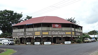
El Arish is a rural town and locality in the Cassowary Coast Region, Queensland, Australia. In the 2016 census, the locality of El Arish had a population of 344 people.

Garradunga is a rural locality in the Cassowary Coast Region, Queensland, Australia. In the 2021 census, Garradunga had a population of 170 people.
Silkwood is a rural town and locality in the Cassowary Coast Region, Queensland, Australia. In the 2016 census, the locality of Silkwood had a population of 391 people.

Cowley Beach is a beach, coastal town and locality in the Cassowary Coast Region, Queensland, Australia. In the 2021 census, the locality of Cowley Beach had a population of 65 people.

Goondi is a locality in the Cassowary Coast Region, Queensland, Australia.

Eubenangee is a coastal locality split between the Cairns Region and the Cassowary Coast Region, Queensland, Australia. In the 2021 census, Eubenangee had a population of 247 people.
Coorumba is a rural locality in the Cassowary Coast Region, Queensland, Australia. In the 2021 census, Coorumba had a population of 137 people.

Daradgee is a rural town and locality in the Cassowary Coast Region, Queensland, Australia. In the 2016 census, Daradgee had a population of 74 people.
Wangan is a town and a locality in the Cassowary Coast Region, Queensland, Australia. In the 2021 census, the locality of Wangan had a population of 612 people.

Ellerbeck is a coastal locality in the Cassowary Coast Region, Queensland, Australia. In the 2021 census, Ellerbeck had a population of 207 people.
Mighell is a rural locality in the Cassowary Coast Region, Queensland, Australia. In the 2021 census, Mighell had a population of 363 people.
Goondi Bend is a mixed-use locality in the Cassowary Coast Region, Queensland, Australia. In the 2021 census, Goondi Bend had a population of 570 people.
Upper Daradgee is a rural locality in the Cassowary Coast Region, Queensland, Australia. In the 2016 census, Upper Daradgee had a population of 101 people.
O'Briens Hill is a rural locality in the Cassowary Coast Region, Queensland, Australia. In the 2021 census, O'Briens Hill had a population of 11 people.
Hudson is a rural locality in the Cassowary Coast Region, Queensland, Australia. In the 2021 census, Hudson had a population of 238 people.
Jaffa is a rural locality in the Cassowary Coast Region, Queensland, Australia. In the 2021 census, Jaffa had a population of 35 people.
Maadi is a rural locality in the Cassowary Coast Region, Queensland, Australia. In the 2021 census, Maadi had a population of 49 people.
