Goolboo, Queensland

Last updated

Goolboo
Queensland
Australia Queensland location map.svg
Red pog.svg
Goolboo
Coordinates 17°43′24″S146°01′41″E / 17.7233°S 146.0280°E / -17.7233; 146.0280 (Goolboo (centre of locality))
Population25 (2021 census) [1]
 • Density4.46/km2 (11.6/sq mi)
Postcode(s) 4856
Area5.6 km2 (2.2 sq mi)
Time zone AEST (UTC+10:00)
Location
LGA(s) Cassowary Coast Region
State electorate(s) Hill
Federal division(s) Kennedy
Suburbs around Goolboo:
Warrubullen Cowley Creek Cowley
No 5 Branch Goolboo McCutcheon
Silkwood Silkwood McCutcheon

Goolboo is a rural locality in the Cassowary Coast Region of Queensland, Australia. [2] In the 2021 census, Goolboo had a population of 25 people. [1]

Contents

Geography

The locality is bounded to the west, north-west, north, and north-east by Liverpool Creek, which eventually flows into the Coral Sea. [3]

The Bruce Highway enters the locality from the south (Silkwood) and exits to the locality to the north-east (Cowley). [3]

The North Coast railway line enters the locality from the south-west (Silkwood) and exits to the north-west (Warrubullen). [3] The locality was served by the now-abandoned Goolboo railway station ( 17°43′03″S146°01′14″E / 17.7175°S 146.0206°E / -17.7175; 146.0206 (Goolboo railway station (former)) ). [4]

The land use is crop growing, predominantly sugarcane. There is a cane tramway network to transport the harvested sugarcane to the South Johnstone sugar mill. [3]

History

The name of the locality originates from a former railway station, which was given the name by the Queensland Railways Department on 4 December, 1924. The name "Goolboo" is derived from an Aboriginal word meaning magpie . [2]

Demographics

In the 2016 census, Goolboo had a population of 19 people. [5]

In the 2021 census, Goolboo had a population of 25 people. [1]

Education

There are no schools in Goolboo. The nearest government primary school is Silkwood State School in neighbouring Silkwood to the south. The nearest government secondary schools are Innisfail State College in Innisfail Estate to the north and Tully State High School in Tully to the south-west. [6]

Related Research Articles

Mundoo is a rural town and locality in the Cassowary Coast Region, Queensland, Australia. In the 2016 census the locality of Mundoo had a population of 224 people.

<span class="mw-page-title-main">Garradunga</span> Suburb of Cassowary Coast Region, Queensland, Australia

Garradunga is a rural locality in the Cassowary Coast Region, Queensland, Australia. In the 2021 census, Garradunga had a population of 170 people.

<span class="mw-page-title-main">Silkwood, Queensland</span> Town in Queensland, Australia

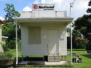
Silkwood is a rural town and locality in the Cassowary Coast Region, Queensland, Australia. In the 2016 census, the locality of Silkwood had a population of 391 people.

<span class="mw-page-title-main">Daradgee, Queensland</span> Town in Queensland, Australia

Daradgee is a rural town and locality in the Cassowary Coast Region, Queensland, Australia. In the 2016 census, Daradgee had a population of 74 people.

Japoonvale is a rural locality in the Cassowary Coast Region, Queensland, Australia. In the 2016 census, Japoonvale had a population of 141 people.

No. 5 Branch is a rural locality in the Cassowary Coast Region, Queensland, Australia. In the 2016 census, the population of the locality was 9 people.

Wangan is a town and a locality in the Cassowary Coast Region, Queensland, Australia. In the 2021 census, the locality of Wangan had a population of 612 people.

<span class="mw-page-title-main">Ellerbeck, Queensland</span> Suburb of Cassowary Coast Region, Queensland, Australia

Ellerbeck is a coastal locality in the Cassowary Coast Region, Queensland, Australia. In the 2021 census, Ellerbeck had a population of 207 people.

Bilyana is a coastal locality in the Cassowary Coast Region, Queensland, Australia. In the 2021 census, Bilyana had a population of 190 people.

<span class="mw-page-title-main">Kurrimine Beach, Queensland</span> Town in Queensland, Australia

Kurrimine Beach is a coastal town and locality in the Cassowary Coast Region, Queensland, Australia. In the 2016 census, the locality of Kurrimine Beach had a population of 729 people.

New Harbourline is a rural locality in the Cassowary Coast Region, Queensland, Australia. In the 2021 census, New Harbourline had a population of 218 people.

Mighell is a rural locality in the Cassowary Coast Region, Queensland, Australia. In the 2021 census, Mighell had a population of 363 people.

Goondi Hill is a semi-urban locality in the Cassowary Coast Region, Queensland, Australia. In the 2021 census, Goondi Hill had a population of 437 people.

Goondi Bend is a mixed-use locality in the Cassowary Coast Region, Queensland, Australia. In the 2021 census, Goondi Bend had a population of 570 people.

<span class="mw-page-title-main">Cowley, Queensland</span> Suburb of Cassowary Coast Region, Queensland, Australia

Cowley is a rural locality in the Cassowary Coast Region, Queensland, Australia. In the 2021 census, Cowley had a population of 82 people.

Currajah is a rural locality in the Cassowary Coast Region, Queensland, Australia. In the 2021 census, Currajah had a population of 57 people.

Hudson is a rural locality in the Cassowary Coast Region, Queensland, Australia. In the 2021 census, Hudson had a population of 238 people.

Jaffa is a rural locality in the Cassowary Coast Region, Queensland, Australia. In the 2021 census, Jaffa had a population of 35 people.

Maadi is a rural locality in the Cassowary Coast Region, Queensland, Australia. In the 2021 census, Maadi had a population of 49 people.

Germantown is a rural locality in the Cassowary Coast Region, Queensland, Australia. In the 2021 census, Germantown had a population of 52 people.

References

  1. 1 2 3 Australian Bureau of Statistics (28 June 2022). "Goolboo (SAL)". 2021 Census QuickStats. Retrieved 28 February 2023. OOjs UI icon edit-ltr-progressive.svg
  2. 1 2 "Goolboo – locality in Cassowary Coast Region (entry 45701)". Queensland Place Names. Queensland Government . Retrieved 29 October 2019.
  3. 1 2 3 4 "Queensland Globe". State of Queensland . Retrieved 12 September 2023.
  4. "Railway stations and sidings - Queensland". Queensland Open Data. Queensland Government. 2 October 2020. Archived from the original on 5 October 2020. Retrieved 5 October 2020.
  5. Australian Bureau of Statistics (27 June 2017). "Goolboo (SSC)". 2016 Census QuickStats. Retrieved 20 October 2018. OOjs UI icon edit-ltr-progressive.svg
  6. "Layers: Locality; Schools and school catchments". Queensland Globe. Queensland Government. Archived from the original on 19 December 2017. Retrieved 12 September 2023.