Flying Fish Point, Queensland

Last updated

Flying Fish Point
Queensland
Australia Queensland location map.svg
Red pog.svg
Flying Fish Point
Coordinates 17°29′50″S146°04′31″E / 17.4972°S 146.0752°E / -17.4972; 146.0752 Coordinates: 17°29′50″S146°04′31″E / 17.4972°S 146.0752°E / -17.4972; 146.0752
Population425 (2016 census) [1]
 • Density77.3/km2 (200.1/sq mi)
Postcode(s) 4860
Area5.5 km2 (2.1 sq mi)
LGA(s) Cassowary Coast Region
State electorate(s) Hill
Federal division(s) Kennedy
Localities around Flying Fish Point:
Wanjuru Wanjuru Coral Sea
Coconuts Flying Fish Point Coral Sea
Coconuts Coral Sea Coral Sea

Flying Fish Point is a coastal town, locality and headland in the Cassowary Coast Region, Queensland, Australia. [2] [3] [4] In the 2016 census, Flying Fish Point had a population of 425 people. [1]

Contents

Geography

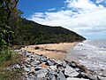
Flying Fish Point is on the northern shore of the mouth of the Johnstone River as it enters the Coral Sea. [5]

History

Enjoying the beach at Flying Fish Point, 1930 StateLibQld 1 258837 Enjoying the beach at Flying Fish Point, Innisfail, 1930.jpg
Enjoying the beach at Flying Fish Point, 1930

The town was originally called Musgrave, but on 1 December 1961 it was officially changed to Flying Fish Point. The town's name comes from the headland, which in turn was named by explorer George Elphinstone Dalrymple on 4 October 1873, after the twelve ton cutter Flying Fish which was the principal vessel of his North East Coast Expedition. [2] [4] The southern shore of the mouth of the Johnstone River, Coquette Point, was named after another cutter in the expedition. [6] C

Thomas Henry Fitzgerald had successfully established sugarcane plantations in the Mackay area and in April 1880 came to Flying Fish Point and planted sugarcane there on 15 June 1880. The focus of his sugarcane interests shifted further up the Johnstone River resulting in the establishing of Geraldton (later Innisfail) as the major sugarcane growing area. Flying Fish Point with its sandy beach instead became a popular holiday town for the area. [7]

The first Catholic mass was celebrated in Flying Fish Point on 1 January 1940 in Edwin Shaw's hut. [8]

Flying Fish Point Provisional School opened on 23 January 1899. It closed on a number of occasions due to low student numbers. It also closed for a period in 1918 after the school building was destroyed in a cyclone in March 1918. [9] [10] The school also closed for a period in World War II from about February 1942 when people were evacuated from the district due to fears of a Japanese invasion but the school did not reopen until 1947. [11] [12] [13] [14] [15] It is unclear when it became Flying Fish Point State School as it is today.

Education

Flying Fish Point State School is a government co-educational primary (P-6) school on Maud Street. In 2016, the school had an enrolment of 56 students with 5 teachers (4 full-time equivalent) and 10 non-teaching staff (5 full-time equivalent). [16]

Community groups

The Flying Fish Point branch of the Queensland Country Women's Association meets at QCWA Hall on Alice Street. [17]

Amenities

The town is home to the Flying Fish Point Tourist Park [18] and a cafe. [19]

Related Research Articles

Innisfail, Queensland Town in Queensland, Australia

Innisfail is a regional town and locality in the Cassowary Coast Region, Queensland, Australia. The town was originally called Geraldton until 1910. In the 2016 census, the town of Innisfail had a population of 7,236 people, while the locality of Innisfail had a population of 1,145 people.

Mission Beach, Queensland Town in Queensland, Australia

Mission Beach is a small coastal town and locality in the Cassowary Coast Region, Queensland, Australia. In the 2016 census Mission Beach and surrounding villages had a total population of 3,597 people.

Shire of Johnstone Local government area in Queensland, Australia

The Shire of Johnstone was a local government area of Queensland. It was located on the Coral Sea coast about 90 kilometres (56 mi) south of the city of Cairns. The shire, administered from the town of Innisfail, covered an area of 1,639.1 square kilometres (632.9 sq mi), and existed as a local government entity from 1881 until 2008, when it amalgamated with the Shire of Cardwell to form the Cassowary Coast Region.

Cassowary Coast Region Local government area in Queensland, Australia

The Cassowary Coast Region is a local government area in the Far North Queensland region of Queensland, Australia, south of Cairns and centred on the towns of Innisfail, Cardwell and Tully. It was created in 2008 from a merger of the Shire of Cardwell and the Shire of Johnstone.

Mundoo, Queensland Town in Queensland, Australia

Mundoo is a rural town and locality in the Cassowary Coast Region, Queensland, Australia. In the 2016 census the locality of Mundoo had a population of 224 people.

Johnstone River river in Queensland, Australia

The Johnstone River, comprising the North Johnstone River and the South Johnstone River, is a river system located in Far North and North Queensland, Australia.

East Innisfail, Queensland Suburb of Cassowary Coast Region, Queensland, Australia

East Innisfail is a suburban locality in the Cassowary Coast Region, Queensland, Australia. In the 2016 census East Innisfail had a population of 1,855 people.

South Johnstone, Queensland Town in Queensland, Australia

South Johnstone is a rural town and locality in the Cassowary Coast Region, Queensland, Australia. In the 2016 census, South Johnstone had a population of 413 people.

Silkwood, Queensland Town in Queensland, Australia

Silkwood is a rural town and locality in the Cassowary Coast Region, Queensland, Australia. In the 2016 census, the locality of Silkwood had a population of 391 people.

Cowley Beach, Queensland Town in Queensland, Australia

Cowley Beach is a beach, coastal town and locality in the Cassowary Coast Region, Queensland, Australia. In the 2016 census the locality of Cowley Beach had a population of 78 people.

Garners Beach, Queensland Suburb of Cassowary Coast Region, Queensland, Australia

Garners Beach is a coastal locality in the Cassowary Coast Region, Queensland, Australia. In the 2016 census, Garners Beach had a population of 25 people.

Feluga, Queensland Suburb of Cassowary Coast Region, Queensland, Australia

Feluga is a rural locality in the Cassowary Coast Region, Queensland, Australia. In the 2016 census Feluga had a population of 251 people.

Eubenangee, Queensland Suburb of Cairns Region, Queensland, Australia

Eubenangee is a coastal locality split between the Cairns Region and the Cassowary Coast Region, Queensland, Australia. In the 2016 census, the population of Eubenangee was 242 people.

Coorumba, Queensland Suburb of Cassowary Coast Region, Queensland, Australia

Coorumba is a rural locality in the Cassowary Coast Region, Queensland, Australia. In the 2016 census, Coorumba had a population of 121 people.

Daradgee, Queensland Town in Queensland, Australia

Daradgee is a rural town and locality in the Cassowary Coast Region, Queensland, Australia. In the 2016 census, Daradgee had a population of 74 people.

Goondi Hill, Queensland Suburb of Cassowary Coast Region, Queensland, Australia

Goondi Hill is a semi-urban locality in the Cassowary Coast Region, Queensland, Australia. In the 2016 census, Goondi Hill had a population of 510 people.

Cullinane, Queensland Suburb of Cassowary Coast Region, Queensland, Australia

Cullinane is a rural locality in the Cassowary Coast Region, Queensland, Australia. In the 2016 census, Cullinane had a population of 524 people.

Innisfail Estate, Queensland Suburb of Cassowary Coast Region, Queensland, Australia

Innisfail Estate is a rural locality in the Cassowary Coast Region, Queensland, Australia. In the 2016 census, Innisfail Estate had a population of 1,338 people.

Upper Daradgee, Queensland Suburb of Cassowary Coast Region, Queensland, Australia

Upper Daradgee is a rural locality in the Cassowary Coast Region, Queensland, Australia. In the 2016 census, Upper Daradgee had a population of 101 people.

Sundown, Queensland (Cassowary Coast Region) Suburb of Cassowary Coast Region, Queensland, Australia

Sundown is a rural locality in the Cassowary Coast Region, Queensland, Australia. In the 2016 census, Sundown had a population of 178 people.

References

  1. 1 2 Australian Bureau of Statistics (27 June 2017). "Flying Fish Point (SSC)". 2016 Census QuickStats. Retrieved 20 October 2018. OOjs UI icon edit-ltr-progressive.svg
  2. 1 2 "Flying Fish Point – town in Cassowary Coast Region (entry 45230)". Queensland Place Names. Queensland Government . Retrieved 5 August 2017.
  3. "Flying Fish Point – locality in Cassowary Coast Region (entry 45698)". Queensland Place Names. Queensland Government . Retrieved 5 August 2017.
  4. 1 2 "Flying Fish Point – headland in the Cassowary Coast Region (entry 12823)". Queensland Place Names. Queensland Government . Retrieved 20 September 2017.
  5. "Queensland Globe". State of Queensland . Retrieved 19 September 2017.
  6. "Coquette Point – headland in the Cassowary Coast Region (entry 8413)". Queensland Place Names. Queensland Government . Retrieved 19 September 2017.
  7. "Glimpses of Country Life". Sydney Mail . Vol. XXXVIII, no. 972. New South Wales, Australia. 12 November 1930. p. 2. Retrieved 21 September 2017 via National Library of Australia.
  8. "Apostolic Blessing to Bishop". Johnstone River Advocate And Innisfail News . No. 8. Queensland, Australia. 5 January 1940. p. 1. Retrieved 21 September 2017 via National Library of Australia.
  9. "THE CYCLONE AREA. INNISFAIL LOSSES". The Brisbane Courier . No. 18, 771. Queensland, Australia. 16 March 1918. p. 6. Retrieved 21 September 2017 via National Library of Australia.
  10. Queensland Family History Society (2010), Queensland schools past and present (Version 1.01 ed.), Queensland Family History Society, ISBN   978-1-921171-26-0
  11. "Flying Fish Point Exodus". Cairns Post . No. 12, 471. Queensland, Australia. 11 February 1942. p. 4. Retrieved 21 September 2017 via National Library of Australia.
  12. "When Will Flying Fish Pt. School Open?". The Evening Advocate . Queensland, Australia. 3 September 1943. p. 4. Retrieved 21 September 2017 via National Library of Australia.
  13. "School Closed At Flying Fish Point". The Evening Advocate . Queensland, Australia. 2 February 1944. p. 4. Retrieved 21 September 2017 via National Library of Australia.
  14. "FLYING FISH POINT NEWS AND SOCIAL". The Evening Advocate . Queensland, Australia. 19 October 1945. p. 3. Retrieved 21 September 2017 via National Library of Australia.
  15. "M.L.A. PLEASED AT SCHOOL RE-OPENING". The Evening Advocate . Queensland, Australia. 15 April 1947. p. 2. Retrieved 21 September 2017 via National Library of Australia.
  16. "Annual Report 2016". Flying Fish Point State School. Retrieved 21 September 2017.
  17. "Branch Locations". Queensland Country Women's Association . Retrieved 26 December 2018.
  18. Flying Fish Point Tourist Park. Flying Fish Point Tourist Park. Retrieved 19 September 2021
  19. Fish Point Cafe. Tripadvisor. Retrieved 19 September 2021

Commons-logo.svg Media related to Flying Fish Point, Queensland at Wikimedia Commons