East Feluga, Queensland

Last updated

East Feluga
Queensland
Australia Queensland location map.svg
Red pog.svg
East Feluga
Coordinates 17°53′46″S145°59′38″E / 17.8961°S 145.9938°E / -17.8961; 145.9938 Coordinates: 17°53′46″S145°59′38″E / 17.8961°S 145.9938°E / -17.8961; 145.9938
Population245 (2016 census) [1]
 • Density10.79/km2 (27.95/sq mi)
Postcode(s) 4854
Area22.7 km2 (8.8 sq mi)
Time zone AEST (UTC+10:00)
LGA(s) Cassowary Coast Region
State electorate(s) Hill
Federal division(s) Kennedy
Suburbs around East Feluga:
Djarawong Friday Pocket Granadilla
Feluga
Midgenoo
East Feluga Granadilla
Merryburn Mount Mackay Mount Mackay

East Feluga is a rural locality in the Cassowary Coast Region, Queensland, Australia. [2] In the 2016 census, East Feluga had a population of 245 people. [1]

History

As of mid-1926 there were several farmers living to the east of the Feluga railway station who decided to band together to have a tram line constructed to transport their produce to the station rather than continuing to use trucks, [3] and by September that year the "East Feluga tramline" had been completed. [4]

In August 1928 a tennis team which described itself as representing East Feluga played a team from El Arish, [5] and in early 1929 a report described East Feluga as being a district three miles east of the Feluga railway station on the slopes of Walter Hill Range with about a dozen settlers mostly growing bananas, with some growing mixed fruits, and struggling to clear their blocks of land. [6] It had one major road leading to Feluga but it was noted that this road was often in a very poor state and unusable during the wet season and it was hoped the Cardwell Shire Council could improve it. As of February there was a Progress Association of East Feluga which was advocating for improvement of the road and promoting the welfare of East Feluga and its residents by raising publicity of the settlement. [7]

In November 1930 repairs to East Feluga road conducted by the Shire Council were completed and much of the area had been cleared of scrub leaving it looking like farmland. [8] In 1931 the Rockingham Farmer's Association raised the need for a road from East Feluga to the coast and decided to make a request for one to be constructed by approaching the Shire Council, the member for Herbert, and the Silkwood Butter Factory directorate, [9] and a request was also made of the Council that the East Feluga farmers be granted permits to grow a small amount of sugar cane as bananas had proven to not be as profitable as expected. [10] It was estimated there were twenty-two farmers living in East Feluga as of September 1931. [11]

In June 1932 delegates from East Feluga were able to participate in a Cardwell Shire conference. [12] In early 1933 a report heavily criticized the outgoing Moore government's treatment of East Feluga settlers, describing them as victims of four years of broken promises due to permits to grow sugar cane never being granted, however in response an official of the Moore government noted that any promise of cane permits would have been made by the preceding McCormack government and argued that the Moore government was never made aware of such a promise and had not made such a promise itself. [13] As of June 1933 sugarcane was being grown in East Feluga with East Feluga farmers participating in a canegrowers meeting in Tully, [14] and an East Feluga side began competing in the Chesney Shield which was a Tully Tennis competition. [15]

In February 1934 flooding severely damaged the roads of East Feluga with Chris Teitzel, chairman of the Cardwell Shire Council, visiting the area personally to inspect them. [16] In order to secure funding for road repairs East Feluga farmers would need to pay a fee to the council to become classified as a "No. 2 Division" (which meant a sugar growing area), however at a Cardwell Shire Council meeting Council member Peter White argued that this would be creating unnecessary hardship and that the roads should be repaired regardless of the settlements classification. [17] As a result, it was instead proposed for a subsidized 2000 pound flood damage loan to be taken by the council to cover the cost of repairs across the region, [18] and in May 1934 work on establishing a brand new road to East Feluga was begun. [19] [20] In June 1934 the Cardwell Shire Council offered a tender of 30 pounds for making improvements to the Djarawong reserve which was to serve as a recreational site for residents of East Feluga, Feluga, Djarawong, and Midgenoo. [21] In July 1934 the Deputy and at the time Acting Premier of Queensland, Percy Pease, visited East Feluga with a ministerial party and met with a deputation representing the East Feluga Progress Association, [22] and after his visit it was arranged for the Chief Inspector of the Lands Department to visit to determine the position of local farmers in relation to relief in land rental fees with the Inspector visiting later the same month. [23] [24] In December 1934 settlers began establishing dairy cattle in East Feluga aiming to supply milk to the Silkwood butter factory. [25]

Related Research Articles

<span class="mw-page-title-main">Tully, Queensland</span> Town in Queensland, Australia

Tully is a town and locality in the Cassowary Coast Region, Queensland, Australia. It is adjacent to the Bruce Highway, approximately 140 kilometres (87 mi) south of Cairns by road and 210 kilometres (130 mi) north of Townsville. At the 2016 census, the population was 2,390. Tully is perhaps best known for being one of the wettest towns in Australia and home to the 7.9 metre tall Golden Gumboot.

<span class="mw-page-title-main">Bruce Highway</span> Highway in Queensland, Australia

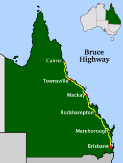
The Bruce Highway is a major highway in Queensland, Australia. Commencing in the state capital, Brisbane, it passes through areas close to the eastern coast on its way to Cairns in Far North Queensland. The route is part of the Australian National Highway and also part of Highway 1, the longest highway route in Australia. Its length is approximately 1,679 kilometres (1,043 mi); it is entirely sealed with bitumen. The highway is named after a popular former Queensland and federal politician, Harry Bruce. Bruce was the state Minister for Works in the mid-1930s when the highway was named after him. The highway once passed through Brisbane, but was truncated at Bald Hills when the Gateway Motorway became National Highway 1 upon its opening in December 1986.

<span class="mw-page-title-main">Ayr, Queensland</span> Town in Queensland, Australia

Ayr is a rural town and locality in the Shire of Burdekin, Queensland, Australia. It is the centre of a sugarcane-growing region and the administrative centre for the Burdekin Shire Council. In the 2016 census, the locality of Ayr had a population of 8,738 people.

<span class="mw-page-title-main">North Coast railway line, Queensland</span> Railway line in Queensland, Australia

The North Coast railway line is a 1,681-kilometre (1,045 mi) 1067 mm railway line in Queensland, Australia. It commences at Roma Street station, Brisbane, and largely parallels the Queensland coast to Cairns in Far North Queensland. The line is electrified between Brisbane and Rockhampton. Along the way, the 1680 km railway passes through the numerous towns and cities of eastern Queensland including Nambour, Bundaberg, Gladstone, Rockhampton, Mackay and Townsville. The line though the centre of Rockhampton runs down the middle of Denison Street.

<span class="mw-page-title-main">Rail transport in Queensland</span>

The rail network in Queensland, Australia, was the first in the world to adopt 1,067 mm narrow gauge for a main line, and now the second largest narrow gauge network in the world, consists of:

<span class="mw-page-title-main">Mossman, Queensland</span> Town in Queensland, Australia

Mossman is a rural town and locality in the Shire of Douglas, Queensland, Australia. It is the administrative centre for the Douglas Shire Council In the 2016 census, the locality of Mossman had a population of 1,937 people.

<span class="mw-page-title-main">Shire of Mareeba</span> Local government area in Queensland, Australia

The Shire of Mareeba is a local government area at the base of Cape York Peninsula in Far North Queensland, inland from Cairns. The shire, administered from the town of Mareeba, covered an area of 53,491 square kilometres (20,653.0 sq mi), and existed as a local government entity from 1879 until 2008, when it amalgamated with several councils in the Atherton Tableland area to become the Tablelands Region.

<span class="mw-page-title-main">Shire of Johnstone</span> Local government area in Queensland, Australia

The Shire of Johnstone was a local government area of Queensland. It was located on the Coral Sea coast about 90 kilometres (56 mi) south of the city of Cairns. The shire, administered from the town of Innisfail, covered an area of 1,639.1 square kilometres (632.9 sq mi), and existed as a local government entity from 1881 until 2008, when it amalgamated with the Shire of Cardwell to form the Cassowary Coast Region.

<span class="mw-page-title-main">Shire of Cardwell</span> Local government area in Queensland, Australia

The Shire of Cardwell was a local government area of Queensland. It was located on the Coral Sea coast about halfway between the cities of Cairns and Townsville. The shire, administered from the town of Tully, covered an area of 3,062.2 square kilometres (1,182.3 sq mi), and existed as a local government entity from 1884 until 2008, when it amalgamated with the Shire of Johnstone to form the Cassowary Coast Region.

<span class="mw-page-title-main">Wallaville</span> Town in Queensland, Australia

Wallaville is a rural town and locality in the Bundaberg Region, Queensland, Australia. It is 372 kilometres (231 mi) north of the state capital, Brisbane and 43 kilometres (27 mi) south west of the regional centre of Bundaberg. In the 2016 census, Wallaville had a population of 410 people.

<span class="mw-page-title-main">Johnstone River</span> River in Queensland, Australia

The Johnstone River, comprising the North Johnstone River and the South Johnstone River, is a river system located in Far North and North Queensland, Australia.

<span class="mw-page-title-main">Michael Martin Clancy</span>

Father Michael Martin Clancy OSA (1868–1931) was an Irish-Australian Roman Catholic priest. He was the first resident Parish Priest in Geraldton, a town and parish in North Queensland, Australia. He was an inspirational parish priest who developed the Parish, established Catholic education in the Johnstone River district and built Innisfail's present Mother of Good Counsel Church. He played an important part in the development in the town and the district. Father Clancy was enthusiastically involved in the life of the town, local committees and governing bodies. He was instrumental in the changing of Geraldton's name to Innisfail in 1910. He also advocated for forging a link to the Atherton Tableland and the use of Mourilyan Harbour by shipping. Mount Father Clancy Garreth McGonnell near the Beatrice River was named in his honour.

'Sugar Lighters in the Johnstone River, Queensland' In the early days of settlement at Geraldton [now Innisfail], the Johnstone River had a sand bar at the mouth and several shallow stretches in the river. This caused difficulties for shipping. Large ships had to either anchor at the mouth of the river and wait for a suitable high tide so that the bar could be crossed or anchor in Mourilyan Harbour to the south. The problem of large ships being unable to enter the river made it difficult for bags of sugar from the district sugar mills to be transported to southern refineries. To overcome this problem, shallow draft steam ships and lighters [often called sugar lighters] were used to carry the bags of sugar down the Johnstone and out to meet larger ships standing off the coast. or in nearby ports, mainly Cairns. These larger ships then transported the cargo to its destination. These small ships became known as "The Mosquito Fleet".

<span class="mw-page-title-main">Richard Alfred Tills</span>

Richard Alfred Tills (1860–1937) was the fourth mayor of Cairns, Australia and the twelfth chairman when Cairns was classified as a borough, a member of the Barron Divisional Board, and president of the Cairns Chamber of Commerce. Born in Kingston upon Hull, England, Tills was a carpenter, architect and one of the pioneers of North Queensland.

Cardstone is a rural locality in the Cassowary Coast Region, Queensland, Australia. In the 2016 census, Cardstone had a population of 17 people.

<span class="mw-page-title-main">Cyclone Winifred</span> Category 3 Australian region cyclone in 1986

Severe Tropical Cyclone Winifred was the worst tropical cyclone to make landfall in northern Queensland and the first since Althea in 1971 to inflict significant damage on the northeastern coast of Australia. The sixth named storm of the 1985–86 Australian region cyclone season, Winifred originated as a tropical low north of Cairns, Queensland on 27 January 1986. Slowly organizing, the system was recognized as a tropical cyclone after gaining tropical characteristics on 30 January, christened with the name Winifred the same day. Meandering southward, the cyclone began to curve southeastward that evening before suddenly turning toward the coast, southwestward, on 31 January, steadily intensifying in that time. By the time it came ashore near Silkwood, Queensland at 0445 UTC on 1 February, it was producing Category 3-force winds on the Australian tropical cyclone intensity scale and a minimum atmospheric pressure of 957 mbar (28.38 inHg). Weakening as it drifted inland, Winifred persisted as a tropical depression for another five days after landfall before finally dissipating on 5 February.

<span class="mw-page-title-main">Cardwell Divisional Board Hall</span> Historic site in Queensland, Australia

Cardwell Divisional Board Hall is a heritage-listed former town hall at 51 Victoria Street, Cardwell, Cassowary Coast Region, Queensland, Australia. It is also known as the Cardwell Shire Chambers, Cardwell Shire Hall, JC Hubinger Memorial Museum, JC Hubinger Museum, and JC Hubinger Memorial Hall. The hall and its World War I honour roll were added to the Queensland Heritage Register on 21 March 2013.

<span class="mw-page-title-main">Exchange Hotel, Mossman</span> Historic site in Queensland, Australia

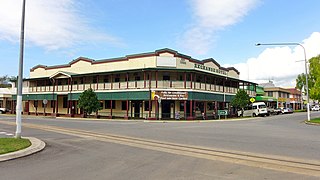
Exchange Hotel is a heritage-listed hotel at 2 Front Street, Mossman, Shire of Douglas, Queensland, Australia. It was designed by Vibert McKirdy Brown and built from 1934 to 1935. It was also known as Daintree Inn. It was added to the Queensland Heritage Register on 9 November 2012.

<span class="mw-page-title-main">Feluga, Queensland</span> Suburb of Cassowary Coast Region, Queensland, Australia

Feluga is a rural locality in the Cassowary Coast Region, Queensland, Australia. In the 2016 census Feluga had a population of 251 people.

<span class="mw-page-title-main">Herbert Rahmann</span> Australian cricketer

Herbert Rahmann was an Australian cricketer. He played in one first-class match for Queensland in 1924/25, and played for University in Brisbane Grade Cricket from 1921 to 1926. In his career he was a teacher and went on to train teachers and served as Inspector of Schools for Queensland.

References

  1. 1 2 Australian Bureau of Statistics (27 June 2017). "East Feluga (SSC)". 2016 Census QuickStats. Retrieved 20 October 2018. OOjs UI icon edit-ltr-progressive.svg
  2. "East Feluga – locality in Cassowary Coast Region (entry 45669)". Queensland Place Names. Queensland Government . Retrieved 29 October 2019.
  3. "Feluga Notes". Townsville Daily Bulletin. Townsville, QLD. 1 June 1926. p. 9. Retrieved 12 January 2021.
  4. "Feluga Notes". Townsville Daily Bulletin. Townsville, QLD. 2 September 1926. p. 11. Retrieved 12 January 2021.
  5. "Feluga Notes". Cairns Post. Cairns, QLD. 11 August 1928. p. 14. Retrieved 12 January 2021.
  6. "East Feluga". Cairns Post. Cairns, QLD. 6 February 1929. p. 11. Retrieved 12 January 2021.
  7. "East Feluga". The Northern Herald. Cairns, QLD. 13 February 1929. p. 44. Retrieved 12 January 2021.
  8. "Tully Notes". Cairns Post. Cairns, QLD. 8 November 1930. p. 11. Retrieved 12 January 2021.
  9. "Rockingham Group Farmers' Association". The Northern Herald. Cairns, QLD. 11 July 1931. p. 30. Retrieved 12 January 2021.
  10. "East Feluga Farmers". The Northern Herald. Cairns, QLD. 19 September 1931. p. 32. Retrieved 12 January 2021.
  11. "Council Meetings". The Brisbane Courier. Brisbane, QLD. 16 September 1931. p. 5. Retrieved 12 January 2021.
  12. "Shire Rating". Cairns Post. Cairns, QLD. 21 June 1932. p. 7. Retrieved 12 January 2021.
  13. "East Feluga Cane Permits". The Telegraph. Brisbane, QLD. 28 February 1933. p. 12. Retrieved 12 January 2021.
  14. "Various Problems for Canegrowers Meeting". Cairns Post. Cairns, QLD. 10 June 1933. p. 16. Retrieved 12 January 2021.
  15. "Tully and District Lawn Tennis". Cairns Post. Cairns, QLD. 17 June 1933. p. 15. Retrieved 12 January 2021.
  16. "Clump Point Area: East Feluga". Cairns Post. Cairns, QLD. 14 February 1934. p. 8. Retrieved 12 January 2021.
  17. "Roads for Farmers". Cairns Post. Cairns, QLD. 16 February 1934. p. 8. Retrieved 12 January 2021.
  18. "Flood Damage". The Northern Herald. Cairns, QLD. 17 March 1934. p. 9. Retrieved 12 January 2021.
  19. "Country News: Tully". The Courier-Mail. Brisbane, QLD. 28 May 1934. p. 17. Retrieved 12 January 2021.
  20. "Dairying: The Tap Route". Cairns Post. Cairns, QLD. 19 May 1934. p. 6. Retrieved 12 January 2021.
  21. "Tender Accepted". Cairns Post. Cairns, QLD. 22 June 1934. p. 7. Retrieved 12 January 2021.
  22. "At Tully: Visit to Sugar Mills". Cairns Post. Cairns, QLD. 7 July 1934. p. 10. Retrieved 12 January 2021.
  23. "Land Rentals". Cairns Post. Cairns, QLD. 19 July 1934. p. 6. Retrieved 12 January 2021.
  24. "Perpetual Lease". Cairns Post. Cairns, QLD. 24 July 1934. p. 6. Retrieved 1 February 2021.
  25. "Butter Factory". Cairns Post. Cairns, QLD. 7 December 1934. p. 8. Retrieved 1 February 2021.