Related Research Articles

Castlereagh Highway is a 790-kilometre (490 mi) state highway located in New South Wales and Queensland, Australia. From north to south the highway traverses South West Queensland and the North West Slopes, Orana, and Central West regions of New South Wales.
Carnarvon Highway is a state highway in Queensland and New South Wales, Australia, linking the township of Rolleston in Queensland's Central Highlands Region, via the town of St George, eventually to Moree in northern New South Wales. It is the main access road to the Carnarvon National Park, and serves as a strategic route to take B-doubles and other large vehicles to the Queensland ports north of Rockhampton.
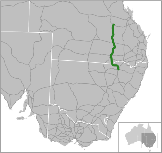
The Gregory Highway is a state highway in Queensland, Australia that serves the major coal-mining centres of Central Queensland. The highway was named after Augustus Gregory, an early explorer.

Atherton is a rural town and locality in the Tablelands Region, Queensland, Australia. In the 2016 census, Atherton had a population of 7,331 people.
The Northern Division of the Queensland Rugby League is responsible for administering the game of rugby league in North Queensland, specifically in the area from Sarina in the south to Cape York and the Torres Strait Islands in the north and west to Mount Isa as well as into the Gulf Communities. There are over 8000 registered players across 36 senior clubs and 39 junior clubs in this division. The Northern Division is responsible for the historic Foley Shield competition that is held each year. Mid West and Mount Isa play in the Toyota Outback Carnival.

Far North Queensland (FNQ) is the northernmost part of the Australian state of Queensland. Its largest city is Cairns and it is dominated geographically by Cape York Peninsula, which stretches north to the Torres Strait, and west to the Gulf Country. The waters of Torres Strait include the only international border in the area contiguous with the Australian mainland, between Australia and Papua New Guinea.

The Kennedy Highway is a highway in northern Queensland, Australia. It runs as National Route 1 for approximately 243 km from Smithfield, on the northern outskirts of Cairns, to the Gulf Developmental Road in the vicinity of Forty Mile Scrub and Undara Volcanic national parks. South of this junction, the road continues as the Kennedy Developmental Road to Boulia about 936 kilometres away, via Hughenden. West of the junction, National Route 1 continues as the Gulf Developmental Road to Normanton.

The Roman Catholic Diocese of Cairns is a diocese of the Catholic Church located in the state of Queensland, Australia. It is a suffragan diocese of the Archdiocese of Brisbane. The diocese was erected as a vicariate apostolic in 1877 and was elevated to a diocese in 1941. Its territorial remit is Far North Queensland.

The Gillies Highway is a road that runs from Gordonvale in the Cairns Region through the Gillies Range to Atherton in the Tablelands Region, both in Queensland, Australia. It is also known as the Gillies Range Road and was originally known as the Cairns Range Road.

The Tablelands Region is a local government area in Far North Queensland, Australia inland from the city of Cairns. Established in 2008, it was preceded by four previous local government areas which dated back more than a century. On 1 January 2014, one of those local government areas, the Shire of Mareeba, was re-established independent of the Tablelands Region.

Queensland's railway construction commenced in 1864, with the turning of the first sod of the Main Line by Lady Diamantina Bowen, the wife of Queensland's first governor Sir George Bowen at Ipswich, Queensland, Australia. A narrow gauge of 3 ft 6 in was selected due to cost savings in providing a rail link to Toowoomba. Despite being built with bridges wide enough for standard gauge, and the fact that most other lines did not require heavy earthworks, the gauge remained the Queensland system norm.
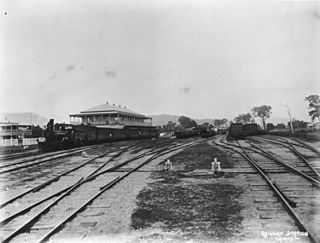
The Tablelands railway line is a railway line in North Queensland, Australia. It was opened in a series of sections between 1887 and 1916. It commences at Cairns and at its maximum extent, reached Ravenshoe at the southern end of the Atherton Tableland. The rail system served by this line was unusual for Queensland in that the majority of lines that connected to it were built by private companies and later purchased by the Queensland Government.

St Patrick's Catholic Church is a heritage-listed church at 1 Penda Street, Yungaburra, Tablelands Region, Queensland, Australia. It was built from 1914 to 1930s. It is also known as Our Lady of Ransom. The church is part of the Roman Catholic Diocese of Cairns. It was added to the Queensland Heritage Register on 21 October 1992.

State Strategic Touring Routes (SSTR) are road routes in Queensland, Australia, which have been identified as significant to motoring tourists. These are the primary routes used by tourists as they provide the connections between popular tourist locations, and consequently have high volumes of tourist traffic. Standardised road signage is used to identify the route itself, with "Welcome to" signage at towns and districts of interest to tourists, as well as "turn off" signage to natural attractions.
The Leichhardt Way is an Australian road route from Melbourne, Victoria to Rockhampton in Queensland. It has been designated by the Queensland Government as a State Strategic Touring Route.
The Pacific Coast Way is an Australian road route from Sydney, New South Wales to Cairns in Queensland. It has been designated by the Queensland Government as a State Strategic Touring Route.
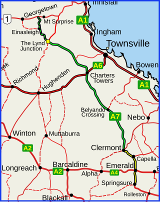
Queensland Inland Freight Route is a proposal to upgrade the existing highways from Charters Towers to Mungindi in Queensland, Australia. It would be a quality two-lane alternative freight route to the Bruce Highway.
Roads of Strategic Importance in Queensland is a list of roads in Queensland, Australia, that are the subject of one or more road improvement projects under the Roads of Strategic Importance (ROSI) initiative of the Australian Government. The purposes of this document are to:
References
- ↑ "Driving Experiences (State Strategic Touring Routes and Tourist Drives)" (PDF). Department of Transport and Main Roads. Queensland Government. February 2016. Archived (PDF) from the original on 27 May 2017. Retrieved 17 July 2017. Licensed CC BY.
- ↑ "Queensland Inland Freight Route". Australia New Zealand Infrastructure Pipeline. 10 May 2021. Retrieved 5 April 2022.
- ↑ "Great Inland Way" (PDF). Royal Automobile Club of Queensland . Retrieved 17 July 2017.