
Yarraman is a rural town and locality in the Toowoomba Region, Queensland, Australia. In the 2016 census, Yarraman had a population of 1,064 people.

Kaimkillenbun is a rural town and locality in the Western Downs Region, Queensland, Australia. In the 2016 census the locality of Kaimkillenbun had a population of 293 people.
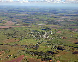
Bell is a rural town and locality in the Western Downs Region, Queensland, Australia. In the 2016 census the locality of Bell had a population of 502 people.

Macalister is a rural town and locality in the Western Downs Region, Queensland, Australia. In the 2016 census the locality of Macalister had a population of 153.

Moola is a rural locality in the Western Downs Region, Queensland, Australia. In the 2016 census Moola had a population of 123 people.

Aubigny is a rural town and locality in the Toowoomba Region, Queensland, Australia. In the 2016 census, Aubigny had a population of 254 people.

Ascot is a rural locality in the Toowoomba Region, Queensland, Australia. In the 2016 census, Ascot had a population of 31 people.

Maclagan is a rural town and locality in the Toowoomba Region, Queensland, Australia. In the 2016 census the locality of Maclagan had a population of 195 people.

Mount Irving is a rural locality in the Toowoomba Region, Queensland, Australia. In the 2016 census, Mount Irving had a population of 15 people.
Jimbour East is a rural locality in the Western Downs Region, Queensland, Australia. In the 2016 census Jimbour East had a population of 199 people.

Brookstead is a rural town and locality in the Toowoomba Region, Queensland, Australia. In the 2016 census, Brookstead had a population of 217 people.
Columboola is a rural town and locality in the Western Downs Region, Queensland, Australia. In the 2016 census the locality of Columboola had a population of 72 people.
Coolabunia is a rural locality in the South Burnett Region, Queensland, Australia. In the 2016 census Coolabunia had a population of 161 people.
Mount Emlyn is a rural locality in the Toowoomba Region, Queensland, Australia. In the 2016 census Mount Emlyn had a population of 16 people.

Thane is a rural town and locality in the Southern Downs Region, Queensland, Australia. In the 2016 census, Thane had a population of 27 people.
Bunya Mountains is a locality split between the Western Downs Region and the South Burnett Region, Queensland, Australia. The town of Mount Mowbullan is located on the boundary of Bunya Mountains and the enclosed locality of Mowbullan. In the 2016 census Bunya Mountains had a population of 144 people.
Nandi is a locality in the Western Downs Region, Queensland, Australia. In the 2016 census, Nandi had a population of 108 people.
Irvingdale is a locality split between the Toowoomba Region and the Western Downs Region, both in Queensland, Australia. In the 2016 census, Irvingdale had a population of 194 people.
Diamondy is a rural locality in the Western Downs Region, Queensland, Australia. In the 2016 census, Diamondy had a population of 47 people.
Passchendaele is a rural locality in the Southern Downs Region, Queensland, Australia. In the 2016 census, Passchendaele had a population of 30 people. The undeveloped town of Messines is located within the locality.
