Weranga, Queensland

Last updated

Weranga
Queensland
Australia Queensland location map.svg
Red pog.svg
Weranga
Coordinates 27°15′51″S150°45′16″E / 27.2641°S 150.7544°E / -27.2641; 150.7544 (Weranga (centre of locality)) Coordinates: 27°15′51″S150°45′16″E / 27.2641°S 150.7544°E / -27.2641; 150.7544 (Weranga (centre of locality))
Population215 (2016 census) [1]
 • Density0.9698/km2 (2.512/sq mi)
Postcode(s) 4405
Area221.7 km2 (85.6 sq mi)
Time zone AEST (UTC+10:00)
LGA(s) Western Downs Region
State electorate(s) Warrego
Federal Division(s) Maranoa
Suburbs around Weranga:
Goranba Kogan Beelbee
Goranba Weranga Kumbarilla
Goranba Marmadua Marmadua

Weranga is a rural locality in the Western Downs Region, Queensland, Australia. [2] In the 2016 census Weranga had a population of 215 people. [1]

Contents

Geography

The Glenmorgan railway line traverses the locality from the south-east (Kumbarilla) to the south-west (Goranba). The locality is served by Weranga railway station on the Weranga North Road ( 27°18′16″S150°43′41″E / 27.3044°S 150.7281°E / -27.3044; 150.7281 (Weranga railway station) ). [3] [4] [5]

History

The locality's name is derived from the parish name and from an early pastoral run established in 1848 by John and Alfred Crowder. The name is believed to be an Aboriginal word meaning a large gathering of Aboriginal Australians. [2]

Weranga Provisional School opened in 1923, but closed in 1924. [6]

In the 2016 census Weranga had a population of 215 people. [1]

Related Research Articles

Gowrie Junction, Queensland Suburb of Toowoomba Region, Queensland, Australia

Gowrie Junction is a rural locality in the Toowoomba Region, Queensland, Australia. It is north-west of Toowoomba. In the 2016 census, Gowrie Junction had a population of 2,120 people. The town of Gowrie is in the eastern part of the locality.

Tara, Queensland Town in Queensland, Australia

Tara is a town and locality in the Western Downs Region, Queensland, Australia. At the 2016 census, Tara had a population of 2,297.

The Gums, Queensland Town in Queensland, Australia

The Gums is a rural town and locality in the Western Downs Region, Queensland, Australia. In the 2016 census, The Gums had a population of 159 people.

Glenmorgan, Queensland Town in Queensland, Australia

Glenmorgan is a town in the Western Downs Region and a locality split between the Western Downs Region and the Maranoa Region, Queensland, Australia.

Glenmorgan railway line

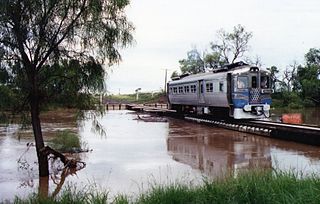
The Glenmorgan Branch is a railway line in south west Queensland, Australia. It opened in a series of sections between 1908 and 1931. It was intended to reach Surat but construction ceased during the 1930s depression and never recommenced.

Toobeah Town in Queensland, Australia

Toobeah is a rural town and locality in the Goondiwindi Region, Queensland, Australia. The locality is on the border of Queensland and New South Wales. In the 2016 census, Toobeah had a population of 191 people.

Guluguba, Queensland Town in Queensland, Australia

Guluguba is a rural town and locality in the Western Downs Region, Queensland, Australia. In the 2016 census the locality of Guluguba had a population of 109 people.

Goombi Suburb of Western Downs Region, Queensland, Australia

Goombi is a rural locality in the Western Downs Region, Queensland, Australia. In the 2016 census Goombi had a population of 34 people.

Kumbarilla, Queensland Suburb of Western Downs Region, Queensland, Australia

Kumbarilla is a town and rural locality in the Western Downs Region, Queensland, Australia. In the 2016 census, Kumbarilla had a population of 197 people.

Hannaford, Queensland Suburb of Western Downs Region, Queensland, Australia

Hannaford is a rural locality in the Western Downs Region, Queensland, Australia. In the 2016 census Hannaford had a population of 118 people.

Columboola, Queensland Town in Queensland, Australia

Columboola is a rural town and locality in the Western Downs Region, Queensland, Australia. In the 2016 census the locality of Columboola had a population of 72 people.

Goomburra, Queensland Town in Queensland, Australia

Goomburra is a rural town and locality in the Southern Downs Region, Queensland, Australia. In the 2016 census the locality of Goomburra had a population of 259 people.

Greymare, Queensland Suburb of Southern Downs Region, Queensland, Australia

Greymare is a rural locality in the Southern Downs Region, Queensland, Australia. In the 2016 census Greymare had a population of 64 people.

Gurulmundi, Queensland Suburb of Western Downs Region, Queensland, Australia

Gurulmundi is a rural locality in the Western Downs Region, Queensland, Australia. In the 2016 census Gurulmundi had a population of 7 people.

Rywung, Queensland Suburb of Western Downs Region, Queensland, Australia

Rywung is a locality in the Western Downs Region, Queensland, Australia.

Cameby, Queensland Suburb of Western Downs Region, Queensland, Australia

Cameby is a rural locality in the Western Downs Region, Queensland, Australia. In the 2016 census, Cameby had a population of 56 people.

Nandi, Queensland Suburb of Western Downs Region, Queensland, Australia

Nandi is a locality in the Western Downs Region, Queensland, Australia. In the 2016 census, Nandi had a population of 108 people.

Goranba, Queensland Suburb of Western Downs Region, Queensland, Australia

Goranba is a locality in the Western Downs Region, Queensland, Australia. In the 2016 census, Goranba had a population of 187 people.

Marmadua, Queensland Suburb of Western Downs Region, Queensland, Australia

Marmadua is a rural locality in the Western Downs Region, Queensland, Australia. In the 2016 census, Marmadua had a population of 9 people.

Dalwogon, Queensland Suburb of Western Downs Region, Queensland, Australia

Dalwogon is a rural locality in the Western Downs Region, Queensland, Australia. In the 2016 census, Dalwogon had a population of 31 people.

References

  1. 1 2 3 Australian Bureau of Statistics (27 June 2017). "Weranga (SSC)". 2016 Census QuickStats. Retrieved 20 October 2018. OOjs UI icon edit-ltr-progressive.svg
  2. 1 2 "Weranga – locality in Western Downs Region (entry 47757)". Queensland Place Names. Queensland Government . Retrieved 29 December 2020.
  3. "Queensland Globe". State of Queensland . Retrieved 4 June 2019.
  4. "Weranga – railway station in the Western Downs Region (entry 37005)". Queensland Place Names. Queensland Government . Retrieved 6 June 2016.
  5. "Queensland Two Mile series sheet 2m47" (Map). Queensland Government. 1939. Archived from the original on 24 April 2020. Retrieved 25 April 2020.
  6. Queensland Family History Society (2010), Queensland schools past and present (Version 1.01 ed.), Queensland Family History Society, ISBN   978-1-921171-26-0