
The Fitzroy River is a river located in Central Queensland, Australia. Its catchment covers an area of 142,665 square kilometres (55,083 sq mi), making it the largest river catchment flowing to the eastern coast of Australia. It is also the largest river basin that discharges onto the Great Barrier Reef.

Murgon is a rural town and locality in the South Burnett Region, Queensland, Australia. In the 2016 census, the locality of Murgon had a population of 2,378 people.

Lands administrative divisions of Australia are the cadastral divisions of Australia for the purposes of identification of land to ensure security of land ownership. Most states term these divisions as counties, parishes, hundreds, and other terms. The eastern states of Queensland, New South Wales, Victoria, and Tasmania were divided into counties and parishes in the 19th century, although the Tasmanian counties were renamed land districts in the 20th century. Parts of South Australia (south-east) and Western Australia (south-west) were similarly divided into counties, and there were also five counties in a small part of the Northern Territory. However South Australia has subdivisions of hundreds instead of parishes, along with the Northern Territory, which was part of South Australia when the hundreds were proclaimed. There were also formerly hundreds in Tasmania. There have been at least 600 counties, 544 hundreds and at least 15,692 parishes in Australia, but there are none of these units for most of the sparsely inhabited central and western parts of the country.

Fitzroy Falls is a village in the Wingecarribee Shire, located within the Southern Highlands region of New South Wales, Australia. The locality was known as Yarrunga, but was renamed after the 81-metre (266 ft) waterfall.

Tingoora is a rural town and a locality in the South Burnett Region, Queensland, Australia.
The Archer brothers were among the earliest European settlers in Queensland, Australia. They were explorers and pastoralists. Seven sons of William Archer, a Scottish timber merchant, they spent varying amounts of time in the colony of New South Wales, mainly in parts of what later became Queensland. A substantial number of locations in Queensland were either named by or for them. They were, in order of birth:

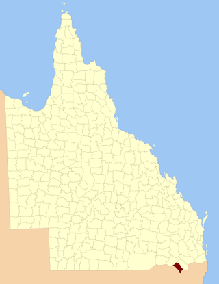
Wicklow County is a county in Queensland, Australia, located in the Wide Bay–Burnett region. On 7 March 1901, the Governor issued a proclamation legally dividing Queensland into counties under the Land Act 1897. Its schedule described Wicklow thus:
Bounded on the east by the county of Yarrol; on the south by the county of Newcastle; on the west by the eastern watershed of the Dawson River; and on the north by the south boundaries of Knockbreak Lease, Calrossie Resumption, Culcragie Lease, part of Culcragie Resumption, and by the north boundary of Eidsvold Resumption.

The County of March is a county in Queensland, Australia. The county consists of the Noosa area, plus the eastern parts of the Gympie and Fraser Coast regions.

The County of Lennox is a county in Queensland, Australia. Like all counties in Queensland, it is a non-functional administrative unit, that is used mainly for the purpose of registering land titles.

The County of Livingstone is a county in Queensland, Australia. It is centred on the city of Rockhampton and includes most of the Rockhampton Region. The county was created on 1 September 1855 by royal proclamation under the Waste Lands Australia Act 1846. On 7 March 1901, the Governor issued a proclamation legally dividing Queensland into counties under the Land Act 1897. Its schedule described Livingstone thus:
Bounded on the south by the county of Deas Thompson and the southern boundaries of the parishes of Plews, Bouldercombe, Mooninera and Playfair; on the west by the western boundaries of the parishes of Playfair, Stanwell, Neerkol, Limestone, Morinish, Yaamba, Canoona and Werribee; on the north by the northern boundaries of the parishes of Werribee, Rosslynn and Yeppoon, and on the east by the Pacific Ocean,—inclusive of Great Keppel, North Keppel, and other adjacent islands.

The County of Bowen is a county in Queensland, Australia, located in the Wide Bay–Burnett region to the west of Bundaberg. It was named in honour of Sir George Ferguson Bowen, the first Governor of Queensland. On 7 March 1901, the Governor issued a proclamation legally dividing Queensland into counties under the Land Act 1897. Its schedule described Bowen thus:
Bounded on the east by the county of Cook; on the south by the county of Mackenzie; on the west by [...] the parishes of Mundowran, Boomerang, Binjour, Jonday, Yenda, Wolca, Wombah, Kolonga and Toweran; and on the north by the northern boundaries of the parishes of Toweran, Kolonga and Manduran.

The County of Yarrol is a county in Queensland, Australia, located in the Wide Bay–Burnett region to the west of Bundaberg. On 7 March 1901, the Governor issued a proclamation legally dividing Queensland into counties under the Land Act 1897. Its schedule described Yarrol thus:
Bounded on the east by the county of Bowen; on the south and west by the Burnett River upwards to the western watershed of Three Moon Creek, by that watershed northerly to the southern watershed of Glassford Creek; and on the north by the southern boundary of the parish of Bompa.

The County of Rawbelle is a county in Queensland, Australia, located in the Wide Bay–Burnett region. On 7 March 1901, the Governor issued a proclamation legally dividing Queensland into counties under the Land Act 1897. Its schedule described Rawbelle thus:
Bounded on the south by the county of Wicklow; on the west by the eastern watershed of the Dawson River; on the north by the northern watersheds of Rawbelle River and Three Moon Creek; and on the east by the county of Yarrol.

The County of Newcastle is a county in the Wide Bay–Burnett region of Queensland, Australia. On 7 March 1901, the Governor issued a proclamation legally dividing Queensland into counties under the Land Act 1897. Its schedule described Newcastle thus:
Bounded on the east by the counties of Mackenzie and Boondooma; on the south by the Main Dividing Range; on the west by the eastern watershed of the Dawson River; on the north by the northern boundaries of the leased parts of Auburn and Hawkwood Runs and the Auburn River from the confluence of Narayen Creek downwards to its junction with the Burnett River.
The County of Clive is a county in the southern Darling Downs region of Queensland, Australia, on the state border with New South Wales. It was named and bounded by the Governor in Council on 7 March 1901 under the Land Act 1897.

Ideraway is a rural town and locality in the North Burnett Region, Queensland, Australia. In the 2016 census, the locality of Ideraway had a population of 38 people.
Wetheron is a rural town and locality in the North Burnett Region, Queensland, Australia. In the 2016 census, Wetheron had a population of 46 people.
Inverlaw is a rural locality in the South Burnett Region, Queensland, Australia.
Burnett Creek is a rural locality in the Scenic Rim Region, Queensland, Australia. In the 2016 census, Burnett Creek had a population of 11 people. It borders New South Wales to the south.
Eidsvold–Theodore Road is a continuous 143.7 kilometres (89.3 mi) road route in the North Burnett and Banana regions of Queensland, Australia. The entire route is signed as State Route 73. It is a state-controlled district road rated as a local road of regional significance.
