County of Aubigny

Last updated
Aubigny
Queensland

Aubigny-county-Queensland.png

Location within Queensland
Lands administrative divisions around Aubigny:
Lytton Boondooma Fitzroy
Derby Aubigny Cavendish
Derby Merivale Churchill
Map all coordinates using: OpenStreetMap  ·  Google Maps
Download coordinates as: KML  ·  GPX

The County of Aubigny is a county (a cadastral division) in Queensland, Australia. [1] Like all counties in Queensland, it is a non-functional administrative unit, that is used mainly for the purpose of registering land titles. The county lies between 151°E and 152°E longitude, and it covers the Toowoomba Region and the Dalby part of the Western Downs Region, [2] The county was named by the Surveyor-General of New South Wales in 1850, possibly to honour the Earl of Arundel who had a long association with the name Aubigny. The area was officially named and bounded by the Governor in Council on 7 March 1901 under the Land Act 1897. [1]

County Geographical and administrative region in some countries

A county is a geographical region of a country used for administrative or other purposes, in certain modern nations. The term is derived from the Old French conté or cunté denoting a jurisdiction under the sovereignty of a count (earl) or a viscount. The modern French is comté, and its equivalents in other languages are contea, contado, comtat, condado, Grafschaft, graafschap, Gau, etc..

Lands administrative divisions of Queensland

Lands administrative divisions of Queensland refers to the divisions of Queensland used for the registration of land titles. There are 322 counties, and 5,319 parishes within the state. They are part of the Lands administrative divisions of Australia. Queensland had been divided into 109 counties in the nineteenth century, before the Land Act of 1897 subdivided many of these counties to 319. Some of the eastern counties remained the same, with most of the subdivisions occurring in the west and north. The current counties were named and bounded by the Governor in Council on 7 March 1901.

Queensland North-east state of Australia

Queensland is the second-largest and third-most populous state in the Commonwealth of Australia. Situated in the north-east of the country, it is bordered by the Northern Territory, South Australia and New South Wales to the west, south-west and south respectively. To the east, Queensland is bordered by the Coral Sea and Pacific Ocean. To its north is the Torres Strait, with Papua New Guinea located less than 200 km across it from the mainland. The state is the world's sixth-largest sub-national entity, with an area of 1,852,642 square kilometres (715,309 sq mi).

Parishes

Aubigny is divided into parishes, listed as follows:

Parish LGA Coordinates Towns
Beauaraba Toowoomba 27°41′S151°35′E / 27.683°S 151.583°E / -27.683; 151.583 (Beauaraba Parish) Pittsworth
Bowenville Toowoomba 27°19′S151°28′E / 27.317°S 151.467°E / -27.317; 151.467 (Bowenville Parish) Bowenville
Cambooya Toowoomba 27°42′S151°51′E / 27.700°S 151.850°E / -27.700; 151.850 (Cambooya Parish) Cambooya
Cecil Plains Toowoomba 27°38′S151°22′E / 27.633°S 151.367°E / -27.633; 151.367 (Cecil Plains Parish) Brookstead, Cecil Plains
Clifton Toowoomba 27°55′S152°00′E / 27.917°S 152.000°E / -27.917; 152.000 (Clifton Parish) Clifton
Cumkillenbar Western Downs 27°02′S151°23′E / 27.033°S 151.383°E / -27.033; 151.383 (Cumkillenbar Parish) Kaimkillenbun
Dalby Western Downs 27°09′S151°18′E / 27.150°S 151.300°E / -27.150; 151.300 (Dalby Parish) Dalby
Douglas Toowoomba 27°19′S151°59′E / 27.317°S 151.983°E / -27.317; 151.983 (Douglas Parish)
Drayton Toowoomba 27°35′S151°56′E / 27.583°S 151.933°E / -27.583; 151.933 (Drayton Parish) Toowoomba, Drayton
East Prairie Toowoomba 27°34′S151°27′E / 27.567°S 151.450°E / -27.567; 151.450 (East Prairie Parish)
Elphinstone Toowoomba 27°57′S151°52′E / 27.950°S 151.867°E / -27.950; 151.867 (Elphinstone Parish)
Eton Vale Toowoomba 27°39′S151°53′E / 27.650°S 151.883°E / -27.650; 151.883 (Eton Vale Parish)
Felton Toowoomba 27°51′S151°40′E / 27.850°S 151.667°E / -27.850; 151.667 (Felton Parish)
Geham Toowoomba 27°24′S152°00′E / 27.400°S 152.000°E / -27.400; 152.000 (Geham Parish) Geham, Hampton
Goombungee Toowoomba 27°17′S151°53′E / 27.283°S 151.883°E / -27.283; 151.883 (Goombungee Parish) Goombungee
Gowrie Toowoomba 27°32′S151°53′E / 27.533°S 151.883°E / -27.533; 151.883 (Gowrie Parish)
Haldon Toowoomba 27°49′S152°02′E / 27.817°S 152.033°E / -27.817; 152.033 (Haldon Parish)
Hodgson Toowoomba 27°48′S151°50′E / 27.800°S 151.833°E / -27.800; 151.833 (Hodgson Parish)
Irvingdale Western Downs 27°09′S151°27′E / 27.150°S 151.450°E / -27.150; 151.450 (Irvingdale Parish)
Isaac Toowoomba 27°30′S151°48′E / 27.500°S 151.800°E / -27.500; 151.800 (Isaac Parish) Kingsthorpe
Jimbour Western Downs 27°00′S151°16′E / 27.000°S 151.267°E / -27.000; 151.267 (Jimbour Parish) Jimbour
Jondaryan Toowoomba 27°23′S151°28′E / 27.383°S 151.467°E / -27.383; 151.467 (Jondaryan Parish) Jondaryan
King Toowoomba 27°21′S151°48′E / 27.350°S 151.800°E / -27.350; 151.800 (King Parish)
Macalister Western Downs 27°04′S151°08′E / 27.067°S 151.133°E / -27.067; 151.133 (Macalister Parish) Macalister
Maida Hill Western Downs 26°54′S151°30′E / 26.900°S 151.500°E / -26.900; 151.500 (Maida Hill Parish) Bell
Meringandan Toowoomba 27°26′S151°50′E / 27.433°S 151.833°E / -27.433; 151.833 (Meringandan Parish) Meringandan
Milton Toowoomba 27°10′S151°46′E / 27.167°S 151.767°E / -27.167; 151.767 (Milton Parish)
Moola Western Downs 27°03′S151°32′E / 27.050°S 151.533°E / -27.050; 151.533 (Moola Parish)
Motley Toowoomba 27°35′S151°37′E / 27.583°S 151.617°E / -27.583; 151.617 (Motley Parish)
Myall Western Downs 27°09′S151°10′E / 27.150°S 151.167°E / -27.150; 151.167 (Myall Parish)
North Branch Toowoomba 27°48′S151°33′E / 27.800°S 151.550°E / -27.800; 151.550 (North Branch Parish)
Pilton Toowoomba 27°54′S152°07′E / 27.900°S 152.117°E / -27.900; 152.117 (Pilton Parish) Pilton
Ramsay Toowoomba 27°44′S151°58′E / 27.733°S 151.967°E / -27.733; 151.967 (Ramsay Parish)
Rolleston Toowoomba 27°43′S151°42′E / 27.717°S 151.700°E / -27.717; 151.700 (Rolleston Parish) Pittsworth, Southbrook
Rosalie Toowoomba 27°09′S151°37′E / 27.150°S 151.617°E / -27.150; 151.617 (Rosalie Parish)
St Ruth Western Downs 27°24′S151°17′E / 27.400°S 151.283°E / -27.400; 151.283 (St Ruth Parish) St Ruth
Stephens Toowoomba 27°56′S151°46′E / 27.933°S 151.767°E / -27.933; 151.767 (Stephens Parish)
Tabletop Toowoomba 27°57′S152°00′E / 27.950°S 152.000°E / -27.950; 152.000 (Tabletop Parish)
Tooth Toowoomba 27°53′S151°49′E / 27.883°S 151.817°E / -27.883; 151.817 (Tooth Parish) Nobby
Toowoomba Toowoomba 27°29′S151°56′E / 27.483°S 151.933°E / -27.483; 151.933 (Toowoomba Parish) Charlton, Gowrie Jn, Highfields
Watts Toowoomba 27°22′S151°40′E / 27.367°S 151.667°E / -27.367; 151.667 (Watts Parish) Oakey
West Prairie Toowoomba 27°28′S151°22′E / 27.467°S 151.367°E / -27.467; 151.367 (West Prairie Parish)
Westbrook Toowoomba 27°35′S151°45′E / 27.583°S 151.750°E / -27.583; 151.750 (Westbrook Parish) Westbrook, Biddeston
Wienholt Western Downs 27°13′S151°26′E / 27.217°S 151.433°E / -27.217; 151.433 (Wienholt Parish)
Yandilla Toowoomba 27°43′S151°20′E / 27.717°S 151.333°E / -27.717; 151.333 (Yandilla Parish)
Young Toowoomba 27°17′S151°23′E / 27.283°S 151.383°E / -27.283; 151.383 (Young Parish)

Related Research Articles

Darling Downs Region in Queensland, Australia

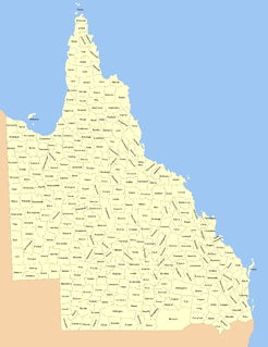
The Darling Downs is a farming region on the western slopes of the Great Dividing Range in southern Queensland, Australia. The Downs are to the west of South East Queensland and are one of the major regions of Queensland. The name was generally applied to an area approximating to that of the Condamine River catchment upstream of Condamine township but is now applied to a wider region comprising the Southern Downs, Western Downs, Toowoomba and Goondiwindi local authority areas. The name Darling Downs was given in 1827 by Allan Cunningham, the first European explorer to reach the area and recognises the then Governor of New South Wales, Ralph Darling.

Shire of Jondaryan Local government area in Queensland, Australia

The Shire of Jondaryan was a local government area located in the Darling Downs region of Queensland, Australia, immediately west of the regional city of Toowoomba. The shire, administered from the town of Oakey, covered an area of 1,910.0 square kilometres (737.5 sq mi), and existed as a local government entity from 1890 until 2008, when it amalgamated with several other councils in the Toowoomba area to form the Toowoomba Region. Its growth in later years has been fuelled by the expansion of Toowoomba and suburbs such as Glenvale and Westbrook.

Shire of Rosalie Local government area in Queensland, Australia

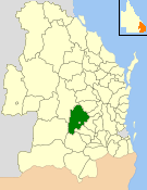
The Shire of Rosalie was a local government area in the Darling Downs region of Queensland, Australia, immediately northwest of the regional city of Toowoomba. The shire, administered from the town of Goombungee, covered an area of 2,200.7 square kilometres (849.7 sq mi), and existed as a local government entity from 1879 until 2008. In 2008, it amalgamated with several other councils in the Toowoomba area to form the Toowoomba Region.

Electoral District of Drayton and Toowoomba was the original seat for the urban settlement on the eastern Darling Downs, Queensland, Australia.

Kaimkillenbun Town in Queensland, Australia

Kaimkillenbun is a town and a locality in the Western Downs Region, Queensland, Australia. At the 2011 census, Kaimkillenbun and the surrounding area had a population of 566.

Shire of Wambo Local government area in Queensland, Australia

The Shire of Wambo was a local government area in the Darling Downs region of Queensland, Australia. The shire completely surrounded but did not include the town of Dalby — which had its own municipal government. It covered an area of 5,709.7 square kilometres (2,204.5 sq mi), and existed as a local government entity from 1879 until 2008, when it amalgamated with the Town of Dalby and the Shires of Chinchilla, Murilla and Tara and the southern part of Taroom to form the Western Downs Region.

Town of Dalby Local government area in Queensland, Australia

The Town of Dalby was a local government area of Queensland, Australia which managed the affairs of Dalby. It was located 85 kilometres (53 mi) north-west of Toowoomba. It was amalgamated into the Western Downs Region in 2008.

Western Downs Region Local government area in Queensland, Australia

Western Downs Region is a local government area in Queensland, Australia. The Western Downs Regional Council manages an area of 38,039 square kilometres (14,687 sq mi), which is approximately the same size as the country of Switzerland, although with a population at the last census of close to 33,000, it is over 235 times less densely populated.

Darling Downs was an electoral district of the Legislative Assembly in the Australian state of Queensland. It was named for the Darling Downs region.

The electoral district of Aubigny was a Legislative Assembly electorate in the state of Queensland. It was first created in a redistribution ahead of the 1873 colonial election, and existed until the 1972 state election.

County of Bentinck Cadastral in Queensland, Australia

The County of Bentinck is a county located on the southern boundary of the state of Queensland, Australia. Like all counties in Queensland, it is a non-functional administrative unit, that is used mainly for the purpose of registering land titles. The county was named in 1838 after William Cavendish-Bentinck, 3rd Duke of Portland, who served as Prime Minister of Great Britain twice, in 1783 and again between 1807 and 1809. Population centres within the County of Bentinck include the towns of Stanthorpe, Wallangarra, Glen Aplin, Applethorpe and Inglewood.

Cecil Plains railway line

The Cecil Plains Branch was a 63 km railway line on the Darling Downs in Queensland, Australia.

County of Merivale Cadastral in Queensland, Australia

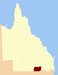
The County of Merivale is a county located on the southern boundary of the state of Queensland, Australia. Like all counties in Queensland, it is a non-functional administrative unit, that is used mainly for the purpose of registering land titles. The county was named in honour of Herman Merivale, the British permanent Under-Secretary of State for the Colonies. Its boundaries were declared and made subject to the Land Act 1897 on 7 March 1901. Population centres within the County of Merivale include the towns of Warwick, Allora and Killarney.

County of Belmore Cadastral in Queensland, Australia

The County of Belmore is a county in Queensland, Australia, located west of the Darling Downs in the Shire of Balonne. Like all counties in Queensland, it is a non-functional administrative unit, that is used mainly for the purpose of registering land titles. It was officially named and bounded by the Governor in Council on 7 March 1901 under the Land Act 1897.

County of Clive, Queensland Cadastral in Queensland, Australia

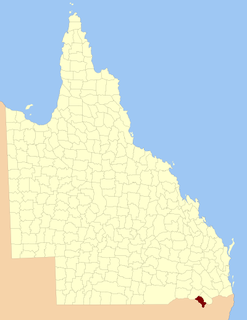
The County of Clive is a county in the southern Darling Downs region of Queensland, Australia, on the state border with New South Wales. It was named and bounded by the Governor in Council on 7 March 1901 under the Land Act 1897.

County of Marsh Cadastral in Queensland, Australia

The County of Marsh is a county in the southern Darling Downs region of Queensland, Australia, on the state border with New South Wales. It was named and bounded by the Governor in Council on 7 March 1901 under the Land Act 1897.

County of Lytton, Queensland Cadastral in Queensland, Australia

The County of Lytton is a county in the Darling Downs region of Queensland, Australia. It was named and bounded by the Governor in Council on 7 March 1901 under the Land Act 1897.

Aubigny, Queensland Town in Queensland, Australia

Aubigny is a town and locality in the Toowoomba Region, Queensland, Australia. At the 2011 census, Aubigny had a population of 386 people.

Burra Burri, Queensland Suburb of Western Downs Region, Queensland, Australia

Burra Burri is a locality in the Western Downs Region, Queensland, Australia. In the 2016 census, Burra Burri had a population of 36 people.

Victoria Hill, Queensland Suburb of Southern Downs Region, Queensland, Australia

Victoria Hill is a locality spit between the Southern Downs Region and the Toowoomba Region, both in Queensland, Australia. In the 2016 census, Victoria Hill had a population of 30 people.

References

  1. 1 2 "Aubigny (county) (entry 980)". Queensland Place Names. Queensland Government . Retrieved 31 August 2015.
  2. Darling Downs District, County of Aubigny Maps - A4 Series at Queensland Archives.

Coordinates: 27°23′S151°35′E / 27.383°S 151.583°E / -27.383; 151.583

Geographic coordinate system Coordinate system

A geographic coordinate system is a coordinate system that enables every location on Earth to be specified by a set of numbers, letters or symbols. The coordinates are often chosen such that one of the numbers represents a vertical position and two or three of the numbers represent a horizontal position; alternatively, a geographic position may be expressed in a combined three-dimensional Cartesian vector. A common choice of coordinates is latitude, longitude and elevation. To specify a location on a plane requires a map projection.