
The Merivale Bridge is a double track railway bridge crossing the Brisbane River. It crosses the Milton Reach of the river, slightly to the west of the William Jolly Bridge. Exclusively a railway crossing, it is located between the stations of South Brisbane and Roma Street, linking the northern and southern elements of the Queensland Rail City network. The Merivale Bridge is the only inner-city rail crossing in Brisbane. By 2016 it was expected to be over capacity, leading the Queensland Government to announce the Cross River Rail project.

The historic counties of Wales are sub-divisions of Wales. They were used for various functions for several hundred years, but have been largely superseded by contemporary sub-national divisions, some of which bear some limited similarity to the historic entities in name and extent. They are alternatively known as ancient counties.
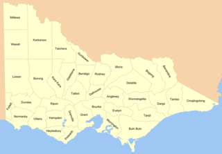
Cadastral divisions in Victoria are called counties, which are further subdivided into parishes and townships, for cadastral or land administration purposes. Cadastral divisions of county, parish and township form the basis for formal identification of the location of any piece of land in the state. There are 37 counties and 2004 parishes and 909 townships. Parishes were subdivided into sections of various sizes for sale as farming allotments, or designated as a town and then divided into sections and these subdivided into crown allotments. However, many parishes do not follow county borders, some being located in more than one county.
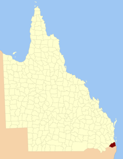
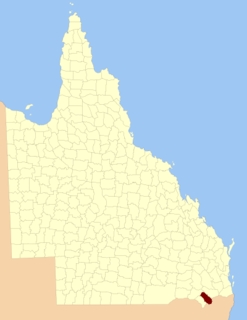
The County of Ward is a county in the south-eastern corner of Queensland, Australia. The main urban area within the county is the city of the Gold Coast, and it also extends to include the southern parts of the West Moreton region centred on Beaudesert and Boonah.

Lands administrative divisions of Australia are the cadastral divisions of Australia for the purposes of identification of land to ensure security of land ownership. Most states term these divisions as counties, parishes, hundreds, and other terms. The eastern states of Queensland, New South Wales, Victoria and Tasmania were divided into counties and parishes in the 19th century, although the Tasmanian counties were renamed land districts in the 20th century. Parts of South Australia (south-east) and Western Australia (south-west) were similarly divided into counties, and there were also five counties in a small part of the Northern Territory. However South Australia has subdivisions of hundreds instead of parishes, along with the Northern Territory, which was part of South Australia when the hundreds were proclaimed. There were also formerly hundreds in Tasmania. There have been at least 600 counties, 544 hundreds and at least 15,692 parishes in Australia, but there are none of these units for most of the sparsely inhabited central and western parts of the country.
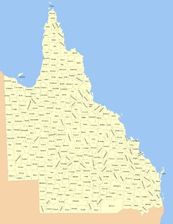
Lands administrative divisions of Queensland refers to the divisions of Queensland used for the registration of land titles. There are 322 counties, and 5,319 parishes within the state. They are part of the Lands administrative divisions of Australia. Queensland had been divided into 109 counties in the nineteenth century, before the Land Act of 1897 subdivided many of these counties to 319. Some of the eastern counties remained the same, with most of the subdivisions occurring in the west and north. The current counties were named and bounded by the Governor in Council on 7 March 1901.

Mirani is a town and locality in Mackay Region, Queensland, Australia. In the 2016 census, Mirani had a population of 1,541 people.

The Merivale River, part of the Darling catchment of the Murray-Darling basin, is a river located in South West Queensland, Australia.
The County of Bentinck is a county located on the southern boundary of the state of Queensland, Australia. Like all counties in Queensland, it is a non-functional administrative unit, that is used mainly for the purpose of registering land titles. The county was named in 1838 after William Cavendish-Bentinck, 3rd Duke of Portland, who served as Prime Minister of Great Britain twice, in 1783 and again between 1807 and 1809. Population centres within the County of Bentinck include the towns of Stanthorpe, Wallangarra, Glen Aplin, Applethorpe and Inglewood.
The County of Cavendish is a county in Queensland, Australia. Like all counties in Queensland, it is a non-functional administrative unit, that is used mainly for the purpose of registering land titles. The county includes the northern part of the Toowoomba Region and the western part of the Somerset Region. The county was officially named and bounded by the Governor in Council on 7 March 1901 under the Land Act 1897.
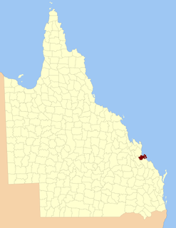
The County of Fitzroy is a county in Queensland, Australia. Like all counties in Queensland, it is a non-functional administrative unit, that is used mainly for the purpose of registering land titles.

Curra is a locality in the Gympie Region, Queensland, Australia. At the 2016 census, Curra had a population of 1,920.
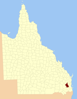
The County of Carlisle is a county in Queensland, Australia. The county is centred on the city of Mackay and includes most of the Mackay Region. It takes its name from Carlisle in England.

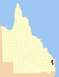
The County of Livingstone is a county in Queensland, Australia. It is centred on the city of Rockhampton and includes most of the Rockhampton Region. The county was created on 1 September 1855 by royal proclamation under the Waste Lands Australia Act 1846. On 7 March 1901, the Governor issued a proclamation legally dividing Queensland into counties under the Land Act 1897. Its schedule described Livingstone thus:
Bounded on the south by the county of Deas Thompson and the southern boundaries of the parishes of Plews, Bouldercombe, Mooninera and Playfair; on the west by the western boundaries of the parishes of Playfair, Stanwell, Neerkol, Limestone, Morinish, Yaamba, Canoona and Werribee; on the north by the northern boundaries of the parishes of Werribee, Rosslynn and Yeppoon, and on the east by the Pacific Ocean,—inclusive of Great Keppel, North Keppel, and other adjacent islands.
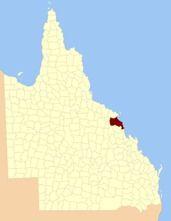
The County of Deas Thompson is a county in Queensland, Australia. It is situated between the cities of Gladstone and Rockhampton. The county was named for Edward Deas Thomson, a New South Wales politician, but the name was misspelt Thompson when applied to the county.

Mirriwinni is a town and a locality in the Cairns Region, Queensland, Australia. The spelling Miriwinni has also been used historically, but Mirriwinni is the official spelling from 8 October 2010. In the 2016 census, Mirriwinni had a population of 447 people.
Ellangowan is a locality in the Toowoomba Region, Queensland, Australia. In the 2016 census, Ellangowan had a population of 121 people.
Owanyilla is a town and a locality in the Fraser Coast Region, Queensland, Australia.
Avondale is a town and a locality in the Bundaberg Region, Queensland, Australia.
