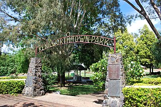
Jimna, Queensland

Last updated

Jimna
Queensland
Australia Queensland location map.svg
Red pog.svg
Jimna
Coordinates 26°39′39″S152°27′54″E / 26.6609°S 152.4649°E / -26.6609; 152.4649 (Jimna (town centre)) Coordinates: 26°39′39″S152°27′54″E / 26.6609°S 152.4649°E / -26.6609; 152.4649 (Jimna (town centre))
Population91 (2016 census locality) [1]
 • Density0.2882/km2 (0.746/sq mi)
Postcode(s) 4515
Area315.8 km2 (121.9 sq mi)
Time zone AEST (UTC+10:00)
Location
LGA(s) Somerset Region
State electorate(s) Nanango
Federal division(s) Blair
Suburbs around Jimna:
Kingaham Lake Borumba Lake Borumba
Monsildale Jimna Kenilworth
Sheep Station Creek Sandy Creek Conondale

Jimna is a rural town and locality in the Somerset Region, Queensland, Australia. [2] [3] In the 2016 census the locality of Jimna had a population of 91 people. [1]

Contents

Geography

Jimna is situated on the Jimna Range approximately 1690 feet (515.11 metres) above sea level. [4]

Jimna Diggings is a neighbourhood in the east of the locality, an area historically used for gold mining ( 26°42′28″S152°32′06″E / 26.7078°S 152.5350°E / -26.7078; 152.5350 (Jimna Diggings) ). [5] [6]

History

Duungidjawu (also known as Kabi Kabi, Cabbee, Carbi, Gabi Gabi) is an Australian Aboriginal language spoken on Duungidjawu country. The Duungidjawu language region includes the landscape within the local government boundaries of Somerset Region and Moreton Bay Region, particularly the towns of Caboolture, Kilcoy, Woodford and Moore . [7]

The name Jimna is believed to be an Aboriginal word djimna meaning place of leeches. [2] [3]

The first Jimna Post Office opened on 1 July 1868 and closed in 1879. A receiving office was open from 1891 to 1909, and from 1925 until the second Jimna Post Office opened on 1 July 1927. This closed in 1981. [8]

In 1887, 42,880 acres (17,350 ha) of land were resumed from the Yabba pastoral run for the establishment of small farms. The land was offered for selection on 17 April 1887. [9]

Monsildale Provisional School opened on 2 June 1913. In 1923, the school was moved and renamed Foxlowe Provisional School. On 25 June 1926 it was renamed Jimna Provisional School. On 1 October 1934, it became Jimna State School. It was mothballed on 31 December 2006 and closed on 31 December 2009. (In about 1941, a separate Monsildale State School was opened but closed about 1961.) [10] [11] [12] [13] It was at 21 School Road ( 26°39′43″S152°27′44″E / 26.6619°S 152.4623°E / -26.6619; 152.4623 (Jimna State School (former)) ). [14] The Jimna school site was developed as a camping ground retaining the school buildings and other facilities. [15]

Commercial loggers Hancock and Gore moved their sawmill from Monsildale to what would become Jimna in 1922. The sawmill was burnt down by fire in 1947. [16]

The state government established a hoop pine nursery at Jimna in 1935. Jimna hall was opened in 1934. [16] When sawmilling contracted in the mid 1970s the town's population reduced significantly. [16]

In the 2016 census the locality of Jimna had a population of 91 people. [1]

Heritage listings

Jimna has a number of heritage-listed sites, including:

Related Research Articles

Kilcoy, Queensland Town in Queensland, Australia

Kilcoy is a rural town and locality in the Somerset Region, Queensland, Australia. In the 2016 census, the locality of Kilcoy had a population of 1,898 people.

Woodford, Queensland Town in Queensland, Australia

Woodford is a rural town and locality in the Moreton Bay Region, Queensland, Australia. In the 2016 census, the locality of Woodford had a population of 3,458 people.

Kandanga Creek is a rural locality in the Gympie Region, Queensland, Australia. In the 2016 census, Kandanga Creek had a population of 118 people.

Shire of Kilcoy Local government area in Queensland, Australia

The Shire of Kilcoy was a local government area in South East Queensland, Australia, about 95 kilometres (59 mi) northwest of Brisbane along the D'Aguilar Highway, not far from the Sunshine Coast. The shire covered an area of 1,445.2 square kilometres (558.0 sq mi), and existed from 1912 until its merger with the Shire of Esk to form the Somerset Region on 15 March 2008.

Moreton Bay Region Local government area in Queensland, Australia

The Moreton Bay Region is a local government area in the north of the Brisbane metropolitan city in South East Queensland, Australia. Established in 2008, it replaced three established local government areas, the City of Redcliffe and the Shires of Pine Rivers and Caboolture.

Somerset Region Local government area in Queensland, Australia

The Somerset Region is a local government area located in the West Moreton region of South East Queensland, Australia, about 100 kilometres (62 mi) northwest of Brisbane and centred on the town of Esk. It was created in 2008 from a merger of the Shire of Esk and the Shire of Kilcoy. It is commonly known as the Brisbane Valley, due to the Brisbane River which courses through the region, although significant parts of the region lie outside the hydrological Brisbane Valley itself.

Moore, Queensland Town in Queensland, Australia

Moore is a rural town and locality in the Somerset Region, Queensland, Australia. In the 2016 census the locality of Moore had a population of 296 people.

Curra, Queensland Suburb of Gympie Region, Queensland, Australia

Curra is a rural residential locality in the Gympie Region, Queensland, Australia. In the 2016 census, Curra had a population of 1,920 people.

Monsildale is a rural locality in the Somerset Region, Queensland, Australia. In the 2016 census, Monsildale had a population of 21 people.

Stony Creek is a rural locality in the Moreton Bay Region of Queensland, Australia. In the 2016 census Stony Creek had a population of 262 people.

Jimna Single Mens Barracks

Jimna Single Men's Barracks is a heritage-listed workers' housing at 4 Tip Road, Jimna, Somerset Region, Queensland, Australia. It was built in 1930s. It was added to the Queensland Heritage Register on 27 November 2008.

Mount Archer, Queensland (Somerset Region) Suburb of Somerset Region, Queensland, Australia

Mount Archer is a mountain and a rural locality in the Somerset Region, Queensland, Australia. In the 2016 census the locality of Mount Archer had a population of 305 people.

Sandy Creek, Queensland Suburb of Somerset Region, Queensland, Australia

Sandy Creek is a rural locality in the Somerset Region, Queensland, Australia. In the 2016 census, Sandy Creek had a population of 567 people.

Mount Kilcoy, Queensland Suburb of Somerset Region, Queensland, Australia

Mount Kilcoy is a rural locality in the Somerset Region, Queensland, Australia. In the 2016 census, Mount Kilcoy had a population of 261 people.

Winya, Queensland Suburb of Somerset Region, Queensland, Australia

Winya is a rural locality in the Somerset Region, Queensland, Australia. In the 2016 census, Winya had a population of 72 people.

Hazeldean, Queensland Suburb of Somerset Region, Queensland, Australia

Hazeldean is a rural locality in the Somerset Region, Queensland, Australia. In the 2016 census, Hazeldean had a population of 262 people.

Lockyer is a rural locality in the Lockyer Valley Region, Queensland, Australia. In the 2016 census Lockyer had a population of 95 people.

Wolvi is a rural locality in the Gympie Region, Queensland, Australia. In the 2016 census, Wolvi had a population of 467 people.

Kinbombi is a rural town and locality in the Gympie Region, Queensland, Australia. In the 2016 census the locality of Kinbombi had a population of 37 people.

Gregors Creek is a rural locality in the Somerset Region, Queensland, Australia. In the 2016 census, Gregors Creek had a population of 96 people.

References

  1. 1 2 3 Australian Bureau of Statistics (27 June 2017). "Jimna (SSC)". 2016 Census QuickStats. Retrieved 20 October 2018. OOjs UI icon edit-ltr-progressive.svg
  2. 1 2 "Jimna – town in Somerset Region (entry 17229)". Queensland Place Names. Queensland Government . Retrieved 29 December 2020.
  3. 1 2 "Jimna – locality in Somerset Region (entry 44876)". Queensland Place Names. Queensland Government . Retrieved 29 December 2020.
  4. 1 2 "Jimna Single Men's Barracks (former) (entry 602685)". Queensland Heritage Register . Queensland Heritage Council. Retrieved 1 August 2014.
  5. "Jimna Diggings – locality unbounded in Somerset Regional (entry 17211)". Queensland Place Names. Queensland Government . Retrieved 29 December 2020.
  6. "Queensland Globe". State of Queensland . Retrieved 2 January 2021.
  7. CC-BY-icon-80x15.png This Wikipedia article incorporates CC-BY-4.0 licensed text from: "Duungidjawu". Queensland Aboriginal and Torres Strait Islander languages map. State Library of Queensland . Retrieved 23 January 2020.
  8. Premier Postal History. "Post Office List". Premier Postal Auctions. Retrieved 10 May 2014.
  9. "Proclamations under the New Land Acts". The Brisbane Courier . Queensland, Australia. 2 March 1877. p. 3. Retrieved 20 February 2020 via Trove.
  10. "Opening and closing dates of Queensland Schools". Queensland Government . Retrieved 7 June 2014.
  11. Queensland Family History Society (2010), Queensland schools past and present (Version 1.01 ed.), Queensland Family History Society, ISBN   978-1-921171-26-0
  12. "Agency ID 5357, Jimna State School". Queensland State Archives . Retrieved 8 June 2014.
  13. "Queensland state school - centre closures" (PDF). Queensland Government . 20 August 2013. Archived (PDF) from the original on 20 March 2022. Retrieved 6 April 2022.
  14. "Nanango" (Map). Queensland Government. 1944. Retrieved 11 April 2022.
  15. "Jimna Base Camp, Jimna Camping". Hipcamp. Retrieved 11 April 2022.
  16. 1 2 3 Environmental Protection Agency (Queensland) (2000). Heritage Trails of the Great South East. State of Queensland. pp. 162–163. ISBN   0-7345-1008-X.
  17. "Jimna Fire Tower (entry 601814)". Queensland Heritage Register . Queensland Heritage Council. Retrieved 12 July 2013.