
The Dawson Highway is a state highway in Queensland, Australia. It runs for 405 kilometres (252 mi) between Gladstone and Springsure where it terminates. From Gladstone to Rolleston it is signed as State Route 60, and then A7 onwards to Springsure. It continues west for another 247 kilometres (153 mi) as Dawson Developmental Road to Tambo on the Landsborough Highway. North of Springsure, A7 becomes the Gregory Highway.

The Brisbane Valley Highway is a state highway in Queensland, Australia. It links the Warrego Highway near Ipswich and the D'Aguilar Highway about 4 km (2 mi) north of Harlin. Its direction follows the approximate course of the Brisbane River. It is part of State Route A17, which is duplexed with the D'Aguilar Highway to Nanango and then becomes the Burnett Highway. State Route 85 is duplexed with the Brisbane Valley Highway from Esk to the D'Aguilar Highway.

The Burnett Highway is an inland rural highway located in Queensland, Australia. The highway runs from its junction with the Bruce Highway at Gracemere, just south of Rockhampton, to the D'Aguilar Highway in Nanango. Its length is approximately 542 kilometres. The highway takes its name from the Burnett River, which it crosses in Gayndah. The Burnett Highway provides the most direct link between the northern end of the New England Highway and Rockhampton. It is designated as a State Strategic Road by the Queensland Government.
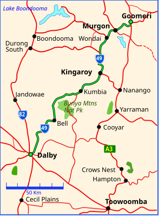
The Bunya Highway is a state highway of Queensland, Australia. It is a relatively short road, running approximately 173 kilometres in a south-westerly direction from Goomeri to Dalby. The highway connects the Warrego and Burnett Highways.

The D'Aguilar Highway is a two-lane highway linking the Bruce Highway near Caboolture with the Bunya Highway in Kingaroy in the state of Queensland, Australia. Major towns along the route include Woodford, Kilcoy, Blackbutt, Yarraman, and Nanango. The highway is approximately 164 km (102 mi) in length. The D'Aguilar Highway's highest elevation along its length is 527 m just north of Yarraman, and the lowest point is at 26.8 m just west of Caboolture.

The Isis Highway is a state highway in southern Queensland, Australia. The highway is relatively short, and runs for 137 kilometres (85 mi) in a north-east / south-west direction between Bundaberg North and the Burnett Highway at Ban Ban Springs. The Isis Highway links the sugar producing Bundaberg and Fraser Coast regions with the cattle farming districts of the North Burnett.

The Wide Bay Highway is a short state highway of Queensland, Australia running between Goomeri on the Burnett Highway and a junction on the Bruce Highway. From the junction it is 12 kilometres south to Gympie or 69 kilometres north to Maryborough. The length of the highway is 62.6 kilometres. It is a state-controlled regional road.
Gladstone–Monto Road is a 132 kilometres (82 mi) road route in the Gladstone and North Burnett regions of Queensland, Australia. The entire route is signed as State Route 69.
Maryborough–Biggenden Road is an 83.4 kilometres (51.8 mi) road route in the Fraser Coast and North Burnett regions of Queensland, Australia. The entire route is signed as State Route 86.
Gin Gin–Mount Perry–Monto Road is a continuous 109.4 kilometres (68.0 mi) road route in the Bundaberg and North Burnett regions of Queensland, Australia. It has two official names, Gin Gin–Mount Perry Road and Monto–Mount Perry Road. The entire route is signed as State Route 12.
Gympie–Brooloo–Kenilworth Road is a continuous 51.6 kilometres (32.1 mi) road route in the Gympie and Sunshine Coast regions of Queensland, Australia. It has two official names, Gympie–Brooloo Road and Kenilworth–Brooloo Road. The entire route is signed as State Route 51.
Eidsvold–Theodore Road is a continuous 143.7 kilometres (89.3 mi) road route in the North Burnett and Banana regions of Queensland, Australia. The entire route is signed as State Route 73. It is a state-controlled district road rated as a local road of regional significance.
Chinchilla–Wondai Road is a continuous 151.6 kilometres (94.2 mi) road route in the Western Downs and South Burnett regions of Queensland, Australia. Part of the route is signed as State Route 82. It is a state-controlled part regional and part district road. It provides an alternate route between the Warrego Highway and the South Burnett, bypassing Dalby, Oakey and Toowoomba.
Richmond–Winton Road is a continuous 145 kilometres (90 mi) road route in the Richmond and Winton local government areas of Queensland, Australia. It is a state-controlled district road rated as a local road of regional significance (LRRS). It is part of the shortest route from the Croydon / Georgetown area to Winton and Longreach. It is also part of the inland freight network linking cattle properties to major freight routes on the Landsborough and Flinders highways.
Proserpine–Shute Harbour Road is a continuous 34.3 kilometres (21.3 mi) road route in the Whitsunday local government area of Queensland, Australia. The route is designated as State Route 59. It is a state-controlled regional road.
Bunya Mountains road network is a group of roads that provide access to the mountain community from various lowland localities. The network ensures continuity of access in times of flooding or other natural disasters, and during planned maintenance activities. The locality of Bunya Mountains includes the Bunya Mountains National Park and the enclosed locality of Mowbullan. The area hosts a small residential community plus many tourism accommodation venues.
Glass House Mountains Road is a continuous 30.4-kilometre (18.9 mi) road route in the Moreton Bay and Sunshine Coast local government areas of Queensland, Australia. Part of it is designated as part of State Route 6. It is a state-controlled road, part regional and part district.
Kilcoy–Beerwah Road is a continuous 30.4-kilometre (18.9 mi) road route in the Moreton Bay and Sunshine Coast local government areas of Queensland, Australia. It is designated as part of State Route 6. It is a state-controlled regional road. It is part of a route that carries tourist traffic from the New England Highway to the Bruce Highway.
Mundubbera–Durong Road is a continuous 105-kilometre (65 mi) road route in the North Burnett and South Burnett local government areas of Queensland, Australia. It is signed as State Route 75. It is a state-controlled regional road. It has been designated as a road of strategic importance by the Federal Government.
Cooroy–Gympie Road is a continuous 29.1 kilometres (18.1 mi) road route in the Noosa and Gympie regions of Queensland, Australia. It is a state-controlled district road. Known as Old Bruce Highway, It runs from Cooroy Connection Road on the Black Mountain / Pomona midpoint to the Bruce Highway in Kybong. This road provides access to several localities bypassed by the current alignment of the highway.