Caboonbah, Queensland

Last updated

Caboonbah
Queensland
Australia Queensland location map.svg
Red pog.svg
Caboonbah
Coordinates 27°08′24″S152°28′34″E / 27.1399°S 152.4761°E / -27.1399; 152.4761 (Caboonbah (centre of locality))
Population13 (2021 census) [1]
 • Density1.57/km2 (4.06/sq mi)
Postcode(s) 4312
Area8.3 km2 (3.2 sq mi)
Time zone AEST (UTC+10:00)
Location
LGA(s) Somerset Region
State electorate(s) Nanango
Federal division(s) Blair
Suburbs around Caboonbah:
Mount Beppo Lake Wivenhoe Lake Wivenhoe
Mount Beppo Caboonbah Lake Wivenhoe
Coal Creek Lake Wivenhoe Lake Wivenhoe

Caboonbah is a rural locality in the Somerset Region, Queensland, Australia. [2] In the 2021 census, Caboonbah had a population of 13 people. [1]

Contents

Geography

The locality is bounded to the south by Lake Wivenhoe and to the east and north by the Brisbane River. [3]

The Esk Kilcoy Road passes through the locality, entering from the south-west (Coal Creek) and exiting to the north-east (the locality of Lake Wivenhoe). [4]

History

The locality name derives from the Caboonbah Homestead built by Henry Plantagenet Somerset. The name derives from the Kabi language "cabon gibbah" meaning big rock. [2]

Caboonbah Homestead was built in 1889-90 for grazier Henry Plantagenet Somerset and his wife Katherine Rose (née McConnel) and their family. [5] It was added to the Queensland Heritage Register on 12 December 1996. [5] It was destroyed by fire in 2009 and removed from the Queensland Heritage Register in 2014. [6] Caboonbah Homestead was on Esk-Kilcoy Road, now with the neighbouring locality of Lake Wivenhoe. [5]

Caboonbah Undenominational Church is a union church. It was established by Henry Plantagenet Somerset and takes its name, "Caboonbah", from the Somerset family homestead, Caboonbah Homestead, nearby. [7] The wooden structure was designed by Somerset's wife Katherine Rose Somerset, the daughter of David Cannon McConnell and Mary McConnel (nee McLeod) who founded the Cressbrook Homestead. The church was built by Lars Andersen. It opened in 1905 to serve the local farming community. It is located on Cressbrook-Caboonbah Road ( 27°08′03″S152°28′02″E / 27.13412°S 152.46732°E / -27.13412; 152.46732 (Caboonbah Undenominational Church) ), now within the neighbouring locality of Mount Beppo. [8]

Demographics

In the 2016 census, Caboonbah had a population of 14 people. [9]

In the 2021 census, Caboonbah had a population of 13 people. [1]

Education

There are no schools in Caboonbah. The nearest government primary and secondary schools are Toogoolawah State School and Toogoolawah State High School respectively, both in Toogoolawah to the north-west. [4]

Related Research Articles

<span class="mw-page-title-main">Brisbane Valley Highway</span> Highway in Queensland, Australia

The Brisbane Valley Highway is a state highway in Queensland, Australia. It links the Warrego Highway near Ipswich and the D'Aguilar Highway about 4 km (2 mi) north of Harlin. Its direction follows the approximate course of the Brisbane River. It is part of State Route A17, which is duplexed with the D'Aguilar Highway to Nanango and then becomes the Burnett Highway. State Route 85 is duplexed with the Brisbane Valley Highway from Esk to the D'Aguilar Highway.

<span class="mw-page-title-main">Esk, Queensland</span> Town in Queensland, Australia

Esk is a rural town and locality in the Somerset Region in South East Queensland, Australia. In the 2021 census, the locality of Esk had a population of 1,641 people.

Lake Wivenhoe is the name of both an artificial lake formed by the Wivenhoe Dam and the locality which contains it in the Somerset Region, Queensland, Australia. In the 2021 census, Lake Wivenhoe had "no people or a very low population".

<span class="mw-page-title-main">Toogoolawah</span> Town in Queensland, Australia

Toogoolawah is a rural town and locality in the Somerset Region, Queensland, Australia. In the 2021 census, Toogoolawah had a population of 1,200 people.

<span class="mw-page-title-main">Somerset Region</span> Local government area in Queensland, Australia

The Somerset Region is a local government area located in the West Moreton region of South East Queensland, Australia, western part of Brisbane. The region is centred on the town of Esk, which serves as the council seat. Somerset was created in 2008 from a merger of the shires of Esk and Kilcoy, and is known as the Brisbane Valley, owing to the Brisbane River which courses through the region. However, significant parts of the region lie outside the hydrological Brisbane Valley.

<span class="mw-page-title-main">Henry Plantagenet Somerset</span> Australian politician

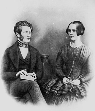
Henry Plantagenet Somerset was a pioneer pastoralist and politician in Queensland, Australia. Somerset was a liberal politician who represented the district of Stanley in the Queensland Legislative Assembly from 1904 to 1920, and canvassed successfully for the extension of the Brisbane Valley railway through the Brisbane River Valley to the rich timber reserves in the Blackbutt Range and beyond. Both the Somerset Dam and the local government area of Somerset Region are named in his honour.

<span class="mw-page-title-main">Caboonbah Undenominational Church</span>

Caboonbah Undenominational Church is a union church on the Cressbrook-Caboonbah Road, Mount Beppo, approximately 21 kilometres (13 mi) from Toogoolawah in the Somerset Region of South East Queensland, Australia. It was founded by Henry Plantagenet Somerset, and built by Lars Andersen in 1905 to serve a farming community at Mount Beppo. The wooden structure was designed by Mrs Katherine Rose Somerset and takes its name, "Caboonbah", from the Somerset family homestead, Caboonbah Homestead, nearby.

<span class="mw-page-title-main">Bryden, Queensland</span> Suburb of Somerset Region, Queensland, Australia

Bryden is a rural locality in the Somerset Region, Queensland, Australia. In the 2021 census, Bryden had a population of 22 people.

<span class="mw-page-title-main">Crossdale, Queensland</span> Suburb of Somerset Region, Queensland, Australia

Crossdale is a rural locality in the Somerset Region, Queensland, Australia. In the 2021 census, Crossdale had a population of 68 people.

<span class="mw-page-title-main">Mount Beppo, Queensland</span> Suburb of Somerset Region, Queensland, Australia

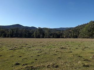
Mount Beppo is a rural locality in the Somerset Region, Queensland, Australia. In the 2021 census, Mount Beppo had a population of 251 people.

<span class="mw-page-title-main">Mount Byron, Queensland</span> Suburb of Somerset Region, Queensland, Australia

Mount Byron is a rural locality in the Somerset Region, Queensland, Australia. In the 2021 census, Mount Byron had a population of 21 people.

<span class="mw-page-title-main">Caboonbah Homestead</span> Historic site in Queensland, Australia

Caboonbah Homestead was a heritage-listed homestead at Esk-Kilcoy Road, Lake Wivenhoe, Somerset Region, Queensland, Australia. It was built from 1889 to 1890. It was added to the Queensland Heritage Register on 12 December 1996. It was destroyed by fire in 2009 and removed from the Queensland Heritage Register in 2014.

Cressbrook is a rural locality in the Somerset Region, Queensland, Australia. In the 2021 census, Cressbrook had a population of 121 people.

<span class="mw-page-title-main">Hazeldean, Queensland</span> Suburb of Somerset Region, Queensland, Australia

Hazeldean is a rural locality in the Somerset Region, Queensland, Australia. In the 2021 census, Hazeldean had a population of 326 people.

<span class="mw-page-title-main">Mary McConnel (pioneer)</span> Scottish-Australian settler

Mary MacLeod McConnel was a Scottish settler in the Australian colony of Queensland, who founded Brisbane's first children's hospital in 1878; it became the Royal Children's Hospital, Brisbane in 1883.

Fulham is a rural locality in the Somerset Region, Queensland, Australia. In the 2021 census, Fulham had a population of 53 people.

Murrumba is a rural locality in the Somerset Region, Queensland, Australia. In the 2021 census, Murrumba had "no people or a very low population".

Glen Esk is a locality in the Somerset Region, Queensland, Australia. In the 2021 census, Glen Esk had a population of 55 people.

<span class="mw-page-title-main">Biarra, Queensland</span> Suburb of Somerset Region, Queensland, Australia

Biarra is a rural locality in the Somerset Region, Queensland, Australia. In the 2021 census, Biarra had a population of 270 people.

Scrub Creek is a rural locality in the Somerset Region, Queensland, Australia. In the 2021 census, Scrub Creek had a population of 33 people.

References

  1. 1 2 3 Australian Bureau of Statistics (28 June 2022). "Caboonbah (SAL)". 2021 Census QuickStats. Retrieved 28 February 2023. OOjs UI icon edit-ltr-progressive.svg
  2. 1 2 "Caboonbah – locality in Somerset Region (entry 44850)". Queensland Place Names. Queensland Government . Retrieved 14 August 2022.
  3. Google (15 September 2021). "Caboonbah, Queensland" (Map). Google Maps . Google. Retrieved 15 September 2021.
  4. 1 2 "Queensland Globe". State of Queensland . Retrieved 6 September 2022.
  5. 1 2 3 "Caboonbah Homestead (entry 601139)". Queensland Heritage Register . Queensland Heritage Council. Retrieved 1 August 2014.
  6. Earley, David (11 May 2009). "Fire destroys Caboonbah Homestead". Courier-Mail . Retrieved 4 July 2015.
  7. "Markets & Rural - Caboonbah". The Courier Mail. 13 December 1939. p. 22. Retrieved 26 August 2012.
  8. "Caboonbah Undenominational Church". Brisbane Valley Historical Society. Archived from the original on 15 June 2005. Retrieved 6 September 2022.
  9. Australian Bureau of Statistics (27 June 2017). "Caboonbah (SSC)". 2016 Census QuickStats. Retrieved 20 October 2018. OOjs UI icon edit-ltr-progressive.svg