Split Yard Creek, Queensland

Last updated

Split Yard Creek
Queensland
Wivenhoe Power Station 2023.jpg
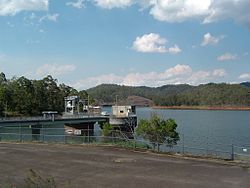
Wivenhoe Power Station entry, 2023
Australia Queensland location map.svg
Red pog.svg
Split Yard Creek
Coordinates 27°22′24″S152°39′34″E / 27.3733°S 152.6594°E / -27.3733; 152.6594
Population37 (2016 census) [1]
 • Density1.609/km2 (4.17/sq mi)
Postcode(s) 4306
Area23.0 km2 (8.9 sq mi)
Time zone AEST (UTC+10:00)
LGA(s) Somerset Region
State electorate(s) Nanango
Federal division(s) Blair
Suburbs around Split Yard Creek:
Lake Wivenhoe Dundas Dundas
Lake Wivenhoe Split Yard Creek England Creek
Lake Wivenhoe Wivenhoe Pocket England Creek

Split Yard Creek is a rural locality in the Somerset Region, Queensland, Australia. [2] In the 2016 census, Split Yard Creek had a population of 37 people. [1]

Geography

The Splityard Creek Dam borders the Wivenhoe-Somerset Road and there is a public carpark on the side of the road with access to the Splityard Creek Lookout. It is home to the Wivenhoe Power Station located between the Splityard Creek Dam and the Wivenhoe Dam. [3]

Related Research Articles

<span class="mw-page-title-main">Wivenhoe Power Station</span> Dam in Wivenhoe Pocket, Queensland

The Wivenhoe Power Station is situated between the Splityard Creek Dam and Lake Wivenhoe. The Splityard Creek Dam is situated in hills adjacent to Lake Wivenhoe and is about 100 metres (330 ft) above it.

Lake Wivenhoe is the name both a lake formed by the Wivenhoe Dam and the locality which contains it in the Somerset Region, Queensland, Australia. In the 2016 census, Lake Wivenhoe had a population of three people.

<span class="mw-page-title-main">Somerset Region</span> Local government area in Queensland, Australia

The Somerset Region is a local government area located in the West Moreton region of South East Queensland, Australia, about 100 kilometres (62 mi) northwest of Brisbane and centred on the town of Esk. It was created in 2008 from a merger of the Shire of Esk and the Shire of Kilcoy. It is commonly known as the Brisbane Valley, due to the Brisbane River which courses through the region, although significant parts of the region lie outside the hydrological Brisbane Valley itself.

<span class="mw-page-title-main">Splityard Creek Dam</span> Dam in South East Queensland

The Splityard Creek Dam is a rock and earth-fill embankment dam with an un-gated spillway across the Pryde Creek that is located in the South East region of Queensland, Australia. The sole purpose of the dam is for the generation of hydroelectricity. The impounded reservoir is called the Splityard Creek Reservoir.

<span class="mw-page-title-main">Banks Creek, Queensland</span> Rural locality split between the City of Brisbane and Somerset Region

Banks Creek is a rural locality split between the City of Brisbane and Somerset Region in Queensland, Australia. The locality is also split for the purposes of state and federal elections. In the 2016 census, Banks Creek had a population of 5 people.

<span class="mw-page-title-main">England Creek, Queensland</span> Rural locality split between the City of Brisbane and Somerset Region

England Creek is a rural locality split between Somerset Region and City of Brisbane, Queensland, Australia. In the 2016 census, England Creek had a population of 33 people.

<span class="mw-page-title-main">Wivenhoe Pocket</span> Suburb of Somerset Region, Queensland, Australia

Wivenhoe Pocket is a rural locality in the Somerset Region, Queensland, Australia. In the 2016 census, Wivenhoe Pocket had a population of 440 people.

<span class="mw-page-title-main">Bryden, Queensland</span> Suburb of Somerset Region, Queensland, Australia

Bryden is a rural locality in the Somerset Region, Queensland, Australia. In the 2016 census, Bryden had a population of 33 people.

<span class="mw-page-title-main">Dundas, Queensland</span> Suburb of Somerset Region, Queensland, Australia

Dundas is a rural locality in the Somerset Region, Queensland, Australia. In the 2016 census Dundas had a population of 77 people.

<span class="mw-page-title-main">Crossdale, Queensland</span> Suburb of Somerset Region, Queensland, Australia

Crossdale is a rural locality in the Somerset Region, Queensland, Australia. In the 2016 census, Crossdale had a population of 75 people.

<span class="mw-page-title-main">Atkinsons Dam, Queensland</span> Suburb of Somerset Region, Queensland, Australia

Atkinsons Dam is a rural locality in the Somerset Region, Queensland, Australia. In the 2016 census Atkinsons Dam had a population of 205 people.

<span class="mw-page-title-main">Glenfern, Queensland</span> Suburb of Somerset Region, Queensland, Australia

Glenfern is a rural locality in the Somerset Region, Queensland, Australia. In the 2016 census Glenfern had a population of 10 people.

<span class="mw-page-title-main">Hazeldean, Queensland</span> Suburb of Somerset Region, Queensland, Australia

Hazeldean is a rural locality in the Somerset Region, Queensland, Australia. In the 2016 census, Hazeldean had a population of 262 people.

Coal Creek is a rural locality in the Somerset Region, Queensland, Australia. In the 2021 census, Coal Creek had a population of 50 people.

Fulham is a rural locality in the Somerset Region, Queensland, Australia. In the 2016 census Fulham had a population of 35 people.

Murrumba is a rural locality in the Somerset Region, Queensland, Australia. In the 2016 census, Murrumba had a population of 16 people.

<span class="mw-page-title-main">Wivenhoe Hill, Queensland</span> Suburb of Somerset Region, Queensland, Australia

Wivenhoe Hill is a locality in the Somerset Region, Queensland, Australia. In the 2016 census, Wivenhoe Hill had a population of 9 people.

Moombra is a locality in the Somerset Region, Queensland, Australia. In the 2016 census, Moombra had a population of 9 people.

Glen Esk is a locality in the Somerset Region, Queensland, Australia. In the 2016 census, Glen Esk had a population of 54 people.

Caboonbah is a rural locality in the Somerset Region, Queensland, Australia. In the 2016 census, Caboonbah had a population of 14 people.

References

  1. 1 2 Australian Bureau of Statistics (27 June 2017). "Split Yard Creek (SSC)". 2016 Census QuickStats. Retrieved 20 October 2018. OOjs UI icon edit-ltr-progressive.svg
  2. "Split Yard Creek – locality in Somerset Region (entry 44919)". Queensland Place Names. Queensland Government . Retrieved 11 June 2019.
  3. "Parks & Reserves". Fernvale.info. Retrieved 14 July 2017.