Patrick Estate, Queensland

Last updated

Patrick Estate
Queensland
Patrick Estate State School 2023.jpg
Patrick Estate State School, 2023
Australia Queensland location map.svg
Red pog.svg
Patrick Estate
Coordinates 27°24′55″S152°35′04″E / 27.4152°S 152.5844°E / -27.4152; 152.5844 (Patrick Estate (centre of locality))
Population199 (2016 census) [1]
 • Density8.77/km2 (22.71/sq mi)
Postcode(s) 4311
Area22.7 km2 (8.8 sq mi)
Time zone AEST (UTC+10:00)
LGA(s) Somerset Region
State electorate(s)
Federal division(s) Blair
Suburbs around Patrick Estate:
Coominya Wivenhoe Hill Lake Wivenhoe
Clarendon Patrick Estate Wivenhoe Pocket
Lowood Wivenhoe Pocket Wivenhoe Pocket

Patrick Estate is a rural locality in the Somerset Region, Queensland, Australia. [2] In the 2016 census Patrick Estate had a population of 199 people. [1]

Contents

Geography

The Brisbane River forms the eastern boundary of the locality. Lockyer Creek forms part of the western boundary before passing through the locality from west to east to its confluence with the Brisbane River. [3]

History

The locality is named after William Patrick and John Patrick, who selected land on the north side of lower reaches of Lockyer Creek on 22 July 1868. [2]

Patrick Estate State School opened on 28 January 1925. [4]

In the 2016 census Patrick Estate had a population of 199 people. [1]

Education

Patrick Estate State School is a government primary (Prep-6) school for boys and girls at 816 Mahon Road ( 27°24′39″S152°34′04″E / 27.4109°S 152.5679°E / -27.4109; 152.5679 (Patrick Estate State School) ). [5] [6] In 2016, the school had an enrolment of 36 students with 4 teachers (3 full-time equivalent) and 6 non-teaching staff (3 full-time equivalent). [7] In 2018, the school had an enrolment of 42 students with 3 teachers (2 full-time equivalent) and 9 non-teaching staff (4 full-time equivalent). [8]

Related Research Articles

<span class="mw-page-title-main">Gatton, Queensland</span> Town in Queensland, Australia

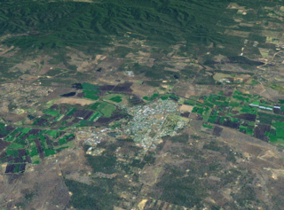
Gatton is a rural town and locality in the Lockyer Valley Region, Queensland, Australia. In the 2016 census, the locality of Gatton had a population of 7,101 people.

<span class="mw-page-title-main">Toogoolawah</span> Town in Queensland, Australia

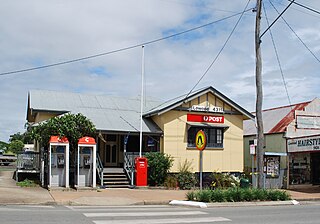
Toogoolawah is a rural town and locality in the Somerset Region, Queensland, Australia. In the 2016 census, Toogoolawah had a population of 1,279 people.

<span class="mw-page-title-main">Laidley, Queensland</span> Town in Queensland, Australia

Laidley is a rural town and locality in the Lockyer Valley Region, Queensland, Australia. In the 2016 census, the locality of Laidley had a population of 3,808 people.

<span class="mw-page-title-main">Prenzlau, Queensland</span> Suburb of Somerset Region, Queensland, Australia

Prenzlau is a rural locality in the Somerset Region, Queensland, Australia. In the 2016 census, Prenzlau had a population of 427 people.

<span class="mw-page-title-main">Lowood, Queensland</span> Town in Queensland, Australia

Lowood is a rural town and locality in the Somerset Region, Queensland, Australia. In the 2016 census, the locality of Lowood had a population of 4,159 people.

<span class="mw-page-title-main">Stafford Heights, Queensland</span> Suburb of Brisbane, Queensland, Australia

Stafford Heights is a northern suburb in the City of Brisbane, Queensland, Australia. In the 2016 census, Stafford Heights had a population of 6,833 people.

Glamorgan Vale is a rural town and locality in the Somerset Region, Queensland, Australia. In the 2016 census, the locality of Glamorgan Vale had a population of 404 people.

<span class="mw-page-title-main">Tarampa</span> Suburb of Somerset Region, Queensland, Australia

Tarampa is a rural locality in the Somerset Region, Queensland, Australia.

<span class="mw-page-title-main">Clarendon, Queensland</span> Suburb of Somerset Region, Queensland, Australia

Clarendon is a rural locality in the Somerset Region, Queensland, Australia. In the 2016 census, Clarendon had a population of 244 people.

<span class="mw-page-title-main">Withcott</span> Town in Queensland, Australia

Withcott is a rural town and locality in the Lockyer Valley Region, Queensland, Australia. In the 2021 census, the locality of Withcott had a population of 2,067 people.

<span class="mw-page-title-main">Harlin</span> Town in Queensland, Australia

Harlin is a rural town and locality in the Somerset Region, Queensland, Australia. In the 2016 census, the locality of Harlin had a population of 173 people.

<span class="mw-page-title-main">Plainland</span> Suburb of Lockyer Valley Region, Queensland, Australia

Plainland is a rural locality and development centre in the Lockyer Valley Region, Queensland, Australia. In the 2021 census, Plainland had a population of 1,930 people - an increase of 21% from the 2016 census.

<span class="mw-page-title-main">Lockrose</span> Suburb of Lockyer Valley Region, Queensland, Australia

Lockrose is a rural locality split between the Lockyer Valley Region and Somerset Region of Queensland, Australia. In the 2016 census, Lockrose had a population of 562 people.

<span class="mw-page-title-main">Blenheim, Queensland</span> Suburb of Lockyer Valley Region, Queensland, Australia

Blenheim is a rural locality in the Lockyer Valley Region, Queensland, Australia. In the 2016 census, Blenheim had a population of 291 people.

<span class="mw-page-title-main">Lower Tenthill, Queensland</span> Suburb of Lockyer Valley Region, Queensland, Australia

Lower Tenthill is a rural locality in the Lockyer Valley Region, Queensland, Australia. In the 2016 census, Lower Tenthill had a population of 252 people.

<span class="mw-page-title-main">Ropeley, Queensland</span> Suburb of Lockyer Valley Region, Queensland, Australia

Ropeley is a rural locality in the Lockyer Valley Region, Queensland, Australia. In the 2016 census Ropeley had a population of 194 people.

<span class="mw-page-title-main">Glenore Grove, Queensland</span> Suburb of Lockyer Valley Region, Queensland, Australia

Glenore Grove is a rural locality in the Lockyer Valley Region, Queensland, Australia. In the 2016 census, Glenore Grove had a population of 883 people.

Kentville is a rural locality in the Lockyer Valley Region, Queensland, Australia. In the 2016 census Kentville had a population of 100 people.

Lake Clarendon is a rural locality in the Lockyer Valley Region, Queensland, Australia. In the 2016 census Lake Clarendon had a population of 288 people.

<span class="mw-page-title-main">Mount Sylvia, Queensland</span> Suburb of Lockyer Valley Region, Queensland, Australia

Mount Sylvia is a rural locality in the Lockyer Valley Region, Queensland, Australia. In the 2016 census, Mount Sylvia had a population of 106 people.

References

  1. 1 2 3 Australian Bureau of Statistics (27 June 2017). "Patrick Estate (SSC)". 2016 Census QuickStats. Retrieved 20 October 2018. OOjs UI icon edit-ltr-progressive.svg
  2. 1 2 "Patrick Estate – locality in Somerset Region (entry 44907)". Queensland Place Names. Queensland Government . Retrieved 29 December 2020.
  3. "Queensland Globe". State of Queensland . Retrieved 12 September 2017.
  4. Queensland Family History Society (2010), Queensland schools past and present (Version 1.01 ed.), Queensland Family History Society, ISBN   978-1-921171-26-0
  5. "State and non-state school details". Queensland Government. 9 July 2018. Archived from the original on 21 November 2018. Retrieved 21 November 2018.
  6. "Patrick Estate State School". Archived from the original on 18 March 2020. Retrieved 21 November 2018.
  7. "Annual Report 2016" (PDF). Patrick Estate State School. Archived (PDF) from the original on 12 September 2017. Retrieved 12 September 2017.
  8. "ACARA School Profile 2018". Australian Curriculum, Assessment and Reporting Authority. Archived from the original on 27 August 2020. Retrieved 28 January 2020.

Further reading