Somerset Dam, Queensland

Last updated

Somerset Dam
Queensland
Streetscape in Somerset Dam, 2020 03.jpg
Streetscape in Somerset Dam, 2020
Australia Queensland location map.svg
Red pog.svg
Somerset Dam
Coordinates 27°07′02″S152°33′05″E / 27.1172°S 152.5513°E / -27.1172; 152.5513 (Somerset Dam (town centre))
Population78 (2021 census) [1]
 • Density3.578/km2 (9.27/sq mi)
Postcode(s) 4312
Area21.8 km2 (8.4 sq mi)
Time zone AEST (UTC+10:00)
Location
  • 25.7 km (16 mi) NE of Esk
  • 71.5 km (44 mi) N of Ipswich
  • 92 km (57 mi) NW of Brisbane
LGA(s) Somerset Region
State electorate(s) Nanango
Federal division(s) Blair
Localities around Somerset Dam:
Cooeeimbardi Hazeldean Crossdale
Cooeeimbardi Somerset Dam Lake Wivenhoe
Lake Wivenhoe Lake Wivenhoe Lake Wivenhoe

Somerset Dam is a rural town and locality in the Somerset Region, Queensland, Australia. [2] [3] When first being planned, it was unofficially known as the Stanley River township. In the 2021 census, the locality of Somerset Dam had a population of 78 people. [1]

Contents

Geography

The town lies on the slopes of Mount Brisbane ( 27°05′19″S152°31′38″E / 27.0886°S 152.5272°E / -27.0886; 152.5272 (Mount Brisbane) ) on the western bank of the Stanley River immediately below and south-west of the wall of the Somerset Dam ( 27°06′55″S152°33′23″E / 27.1154°S 152.5565°E / -27.1154; 152.5565 (Somerset Dam) ) which impounds the river creating Lake Somerset ( 27°02′00″S152°34′00″E / 27.0333°S 152.5667°E / -27.0333; 152.5667 (Lake Somerset) ). [4] [5] [6]

The Deer Reserve National Park ( 27°04′52″S152°31′34″E / 27.0811°S 152.526°E / -27.0811; 152.526 (Deer Reserve National Park (centre point)) ) is in the north-west of the locality. The national park is 3,228 hectares (7,980 acres) and extends into the neighbouring localities of Hazeldean to the north, Cooeeimbardi to the north-west and Fulham further to the north-west. [7] [8]

History

Stanley River Township from Quarry Hill, 1937 Queensland State Archives 4577 Stanley River Township from Quarry Hill 18 August 1937.png
Stanley River Township from Quarry Hill, 1937

The town was constructed in 1935 to provide accommodation for those working on the construction of the dam and their families with the first businesses opening in 1936. The town was designed by civil engineer Charles Bank Mott like a suburban with gravel streets, electricity, street lights, reticulated water, stormwater drainage, and sewerage. Mott was seconded for three years from the Brisbane City Council. [9]

When the project commenced, the town was informally known as the Stanley River township. The Queensland Government decided to call the town Somerset after local pastoralist Henry Plantagenet Somerset, the Member of the Queensland Legislative Assembly for Stanley from 1904 to 1920. However, the postal authorities objected, fearing confusion with Somerset in Far North Queensland and Somerset in Tasmania. In January 1936 it was officially named Somerset Dam after the dam, which was named after Henry Plantagenet Somerset. [2] [10]

As there was already a Somerset State School near Kilcoy (which had opened in 1915), the education authorities had decided to call the town's school Silverton. Silverton Provisional School opened in February 1936 at the end of First Avenue ( 27°07′04″S152°33′02″E / 27.1178°S 152.5505°E / -27.1178; 152.5505 (Somerset Dam State School (former)) ). [11] [12] In 1958, it became Silverton State School. Circa 1959, it was renamed Somerset State School (the school of that name near Kilcoy having closed in 1943). On 24 January 1966, it renamed Somerset Dam State School. It closed on 31 December 2000. [13]

A community hall was officially opened on Wednesday 22 July 1936. It was constructed by the Stanley River Works Board (who were responsible for the construction of the dam) and could seat 200 people. It could be used as a dance hall and had projection facilities to be used as a cinema. Initially opened as Somerset Hall, by 1938 it had become known as Coronation Hall (presumably in honour of the Coronation of King George VI in 1937). [14] [15]

St Mark's Anglican Church, circa 1936 Queensland State Archives 4558 Church of England and school ground First Avenue Stanley River Township c 1936.png
St Mark's Anglican Church, circa 1936

The dam was being built as part of a program of providing employment during the Great Depression. During World War II construction of the dam was halted to enable the workers to be redeployed on war-related work, such as the Cairncross Dockyard with work resuming in 1948. About 450 people were employed constructing the dam during which time the population of the town exceeded 1000 people. [9]

St Mark's Anglican Church at First Avenue ( 27°07′04″S152°33′03″E / 27.1177°S 152.5508°E / -27.1177; 152.5508 (St Mark's Anglican Church (former)) ) was dedicated on 30 August 1936 by Archbishop William Wand. [16] [17] The church building was the former St Mark's Anglican Church of Fernvale which, having closed in 1934, was purchased by the Queensland Government for £50, relocated to Somerset Dam, renovated and re-roofed. [18] [19] The church closed circa 1995. [20] As at 2020, the church building still exists but has been converted to holiday accommodation. [21]

On the same day and at the same time as the Anglican church was dedicated, so too was St Joseph's Catholic Church at 5 King Street ( 27°07′07″S152°33′04″E / 27.1187°S 152.5510°E / -27.1187; 152.5510 (St Joseph's Catholic Church) ). It was blessed and dedicated by Archbishop James Duhig. [16] [22]

Demographics

St Joseph's Catholic Church, 2020 St Joseph's Catholic Church, Somerset Dam, 2020 02.jpg
St Joseph's Catholic Church, 2020

In the 2016 census, the locality of Somerset Dam had a population of 69 people. [23]

In the 2021 census, the locality of Somerset Dam had a population of 78 people. [1]

Education

Coronation Hall, 2020 Coronation Hall, Somerset Dam, 2020 02.jpg
Coronation Hall, 2020

There are no schools in Somerset Dam. The nearest government primary schools are Toogoolawah State School in Toogoolawah to the west and Kilcoy State School in Kilcoy to the north. The nearest government secondary schools are Toogoolawah State High School, also in Toogooolawah, and Kilcoy State High School, also in Kilcoy. [24]

Amenities

St Joseph's Catholic Church is at 5 King Street ( 27°07′07″S152°33′04″E / 27.1187°S 152.5510°E / -27.1187; 152.5510 (St Joseph's Catholic Church) ). It is part of the Parish of St Mel's at Esk. [25]

Coronation Hall is at 2 Short Street. It is operated by the Somerset Regional Council and continues to be used for local events and as a wedding venue. [26] [27]

Related Research Articles

<span class="mw-page-title-main">Toogoolawah</span> Town in Queensland, Australia

Toogoolawah is a rural town and locality in the Somerset Region, Queensland, Australia. In the 2021 census, Toogoolawah had a population of 1,200 people.

<span class="mw-page-title-main">Kilcoy, Queensland</span> Town in Queensland, Australia

Kilcoy is a rural town and locality in the Somerset Region, Queensland, Australia. In the 2021 census, the locality of Kilcoy had a population of 1,996 people.

<span class="mw-page-title-main">Woodford, Queensland</span> Town in Australia

Woodford is a rural town and locality in the City of Moreton Bay, Queensland, Australia. In the 2021 census, the locality of Woodford had a population of 4,022 people.

<span class="mw-page-title-main">Fernvale, Queensland</span> Town in Queensland, Australia

Fernvale is a rural town and locality in the Somerset Region, Queensland, Australia. In the 2021 census, the locality of Fernvale had a population of 3,629 people.

<span class="mw-page-title-main">Somerset Region</span> Local government area in Queensland, Australia

The Somerset Region is a local government area located in the West Moreton region of South East Queensland, Australia, northwest of the City of Brisbane. The region is centred on the town of Esk, which also serves as the council seat. Somerset was created in 2008 from a merger of the shires of Esk and Kilcoy, and is known as the Brisbane Valley, owing to the Brisbane River which courses through the region. However, significant parts of the region lie outside the hydrological Brisbane Valley.

<span class="mw-page-title-main">Moore, Queensland</span> Town in Queensland, Australia

Moore is a rural town and locality in the Somerset Region, Queensland, Australia. In the 2021 census, the locality of Moore had a population of 286 people.

<span class="mw-page-title-main">Peachester, Queensland</span> Town in Queensland, Australia

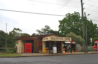
Peachester is a rural town and locality in the Sunshine Coast Region, Queensland, Australia. In the 2021 census, the locality of Peachester had a population of 1,460 people.

<span class="mw-page-title-main">Jimna, Queensland</span> Town in Queensland, Australia

Jimna is a rural town and locality in the Somerset Region, Queensland, Australia. In the 2021 census, the locality of Jimna had a population of 70 people.

<span class="mw-page-title-main">Villeneuve, Queensland</span> Town in Queensland, Australia

Villeneuve is a rural town and locality in the Somerset Region, Queensland, Australia. In the 2021 census, the locality of Villeneuve had a population of 193 people.

<span class="mw-page-title-main">Crossdale, Queensland</span> Suburb of Somerset Region, Queensland, Australia

Crossdale is a rural locality in the Somerset Region, Queensland, Australia. In the 2021 census, Crossdale had a population of 68 people.

<span class="mw-page-title-main">Mount Delaney</span> Suburb of City of Moreton Bay, Queensland, Australia

Mount Delaney is a rural locality in the City of Moreton Bay, Queensland, Australia. In the 2021 census, Mount Delaney had a population of 80 people.

Cressbrook is a rural locality in the Somerset Region, Queensland, Australia. In the 2021 census, Cressbrook had a population of 121 people.

<span class="mw-page-title-main">Glenfern, Queensland</span> Suburb of Somerset Region, Queensland, Australia

Glenfern is a rural locality in the Somerset Region, Queensland, Australia. In the 2021 census, Glenfern had a population of 11 people.

<span class="mw-page-title-main">Winya, Queensland</span> Suburb of Somerset Region, Queensland, Australia

Winya is a rural locality in the Somerset Region, Queensland, Australia. In the 2021 census, Winya had a population of 127 people.

<span class="mw-page-title-main">Hazeldean, Queensland</span> Suburb of Somerset Region, Queensland, Australia

Hazeldean is a rural locality in the Somerset Region, Queensland, Australia. In the 2021 census, Hazeldean had a population of 326 people.

Fulham is a rural locality in the Somerset Region, Queensland, Australia. In the 2021 census, Fulham had a population of 53 people.

Caboonbah is a rural locality in the Somerset Region, Queensland, Australia. In the 2021 census, Caboonbah had a population of 13 people.

<span class="mw-page-title-main">Braemore, Queensland</span> Suburb of Somerset Region, Queensland, Australia

Braemore is a rural locality in the Somerset Region, Queensland, Australia. In the 2021 census, Braemore had a population of 131 people.

Gregors Creek is a rural locality in the Somerset Region, Queensland, Australia. In the 2021 census, Gregors Creek had a population of 87 people.

Ivory Creek is a rural locality in the Somerset Region, Queensland, Australia. In the 2021 census, Ivory Creek had a population of 49 people.

References

  1. 1 2 3 Australian Bureau of Statistics (28 June 2022). "Somerset Dam (SAL)". 2021 Census QuickStats. Retrieved 28 February 2023. OOjs UI icon edit-ltr-progressive.svg
  2. 1 2 "Somerset Dam – town in Somerset Region (entry 31389)". Queensland Place Names. Queensland Government . Retrieved 16 May 2020.
  3. "Somerset Dam – locality in Somerset Region (entry 44917)". Queensland Place Names. Queensland Government . Retrieved 16 May 2020.
  4. "Queensland Globe". State of Queensland . Retrieved 3 July 2020.
  5. "Mount Brisbane – mountain in the Somerset Region (entry 4564)". Queensland Place Names. Queensland Government . Retrieved 3 July 2020.
  6. "Lake Somerset – reservoir in the Somerset Region (entry 31392)". Queensland Place Names. Queensland Government . Retrieved 3 July 2020.
  7. "Queensland Globe". State of Queensland . Retrieved 3 July 2020.
  8. "Deer Reserve National Park – National park in the Somerset Region (entry 44059)". Queensland Place Names. Queensland Government . Retrieved 3 July 2020.
  9. 1 2 "Nomination Document for the Somerset Dam" (PDF). Engineers Australia . January 2010. Archived (PDF) from the original on 3 July 2020. Retrieved 3 July 2020.
  10. ""SOMERSET DAM"". The Courier-mail . No. 739. Queensland, Australia. 11 January 1936. p. 12. Retrieved 3 July 2020 via National Library of Australia.
  11. "THE SILVERTON STATE SCHOOL". Queensland Times . Vol. LXXVI, no. 15, 369. Queensland, Australia. 17 February 1936. p. 8 (DAILY). Archived from the original on 15 December 2021. Retrieved 3 July 2020 via National Library of Australia.
  12. "Town of Somerset Dam" (Map). Queensland Government. 1973. Archived from the original on 3 July 2020. Retrieved 28 April 2022.
  13. Queensland Family History Society (2010), Queensland schools past and present (Version 1.01 ed.), Queensland Family History Society, ISBN   978-1-921171-26-0
  14. "NEW HALL AT SOMERSET DAM". The Courier-mail . No. 905. Queensland, Australia. 24 July 1936. p. 22. Retrieved 22 December 2024 via National Library of Australia.
  15. "Social". Queensland Times . Vol. LXXIX, no. 16, 201. Queensland, Australia. 25 October 1938. p. 4 (DAILY.). Retrieved 22 December 2024 via National Library of Australia.
  16. 1 2 "CHURCHES DEDICATED". Queensland Times . Vol. LXXVII, no. 15, 536. Queensland, Australia. 31 August 1936. p. 8 (DAILY.). Retrieved 31 May 2019 via National Library of Australia.
  17. "St. Mark's Church". Queensland Times . Vol. LXXVII, no. 15, 536. Queensland, Australia. 31 August 1936. p. 8 (DAILY.). Retrieved 3 July 2020 via National Library of Australia.
  18. "RELIGIOUS NOTES". The Courier-mail . No. 698. Queensland, Australia. 23 November 1935. p. 5. Retrieved 17 February 2021 via National Library of Australia.
  19. "TWO NEW CHURCHES AT STANLEY DAM". Queensland Times . Vol. LXXVII, no. 15, 535. Queensland, Australia. 29 August 1936. p. 8 (DAILY.). Archived from the original on 14 December 2021. Retrieved 28 July 2020 via National Library of Australia.
  20. "Closed Anglican Churches". Anglican Church South Queensland. Archived from the original on 3 April 2019. Retrieved 29 June 2020.
  21. "The Church Somerset Dam". Archived from the original on 3 July 2020. Retrieved 3 July 2020.
  22. "St. Joseph's Church". Queensland Times . Vol. LXXVII, no. 15, 536. Queensland, Australia. 31 August 1936. p. 8 (DAILY.). Retrieved 3 July 2020 via National Library of Australia.
  23. Australian Bureau of Statistics (27 June 2017). "Somerset Dam (SSC)". 2016 Census QuickStats. Retrieved 20 October 2018. OOjs UI icon edit-ltr-progressive.svg
  24. "Layers: Locality; Schools and school catchments". Queensland Globe. Queensland Government. Archived from the original on 19 December 2017. Retrieved 21 December 2024.
  25. "St Joseph's Church, Somerset Dam". Archdiocese of Brisbane. Archived from the original on 3 July 2020. Retrieved 3 July 2020.
  26. "Coronation Hall". Experience Somerset. Archived from the original on 26 October 2024. Retrieved 21 December 2024.
  27. "Coronation Hall Somerset Dam". Tourism & Events Queensland. Queensland Government. Retrieved 21 December 2024.

Further reading