Dundas, Queensland

Last updated

Dundas
Queensland
D'Aguilar Red Cedar Park 2023.jpg
Red Cedar Park, 2023
Australia Queensland location map.svg
Red pog.svg
Dundas
Coordinates 27°17′55″S152°41′04″E / 27.2986°S 152.6844°E / -27.2986; 152.6844 (Dundas (centre of locality))
Population77 (2016 census) [1]
 • Density0.624/km2 (1.616/sq mi)
Postcode(s) 4306
Area123.4 km2 (47.6 sq mi)
Time zone AEST (UTC+10:00)
Location
  • 52.6 km (33 mi) SE of Esk
  • 47.5 km (30 mi) N of Ipswich
  • 73.4 km (46 mi) NW of Brisbane
LGA(s) Somerset Region
State electorate(s) Nanango
Federal division(s) Blair
Suburbs around Dundas:
Bryden Mount Byron Laceys Creek
Bryden
Lake Wivenhoe
Dundas Laceys Creek
Mount Glorious
Lake Wivenhoe Split Yard Creek England Creek

Dundas is a rural locality in the Somerset Region, Queensland, Australia. [2] In the 2016 census Dundas had a population of 77 people. [1]

Contents

Geography

A majority of Dundas is protected within the D'Aguilar National Park. Several peaks of the D'Aguilar Range are in Dundas, including Mount Sim Jue, The Bulls Knob, Northbrook and Tenison Woods Mountain, the highest peak on the range. The Northbrook Parkway is the only crossing over the D'Aguilar Range, connecting the south of the Somerset Region with the City of Moreton Bay.

Dundas borders the Wivenhoe Dam and the public boating facilities of Billy's Bay. [3] The area is best accessed via Wivenhoe-Somerset Road on approach from Fernvale. Public access to this area by public transport is limited to a local school bus service.

The natural park like attributes of this area make it ideal for wildlife. It is not uncommon to hear songbirds and to see bush turkeys in the natural forest, and eagles flying overhead at the peaks of the local mountains. Deer which was the emblem of the Shire of Esk can be spotted in the area on rare occasion. Lake Wivenhoe allows Dundas residents to see the sunset over water (not normally possible in South-East Queensland).

There are some public parks and recreational facilities in the Dundas area in addition to Billy's Bay. They include the Lake Wivenhoe Branch Creek Day Use Area, maintained by SEQ Water, located on Wivenhoe-Somerset Road near Kipper Creek Road and two parks: Red Cedar and White Cedar, both located on the Western approach of the Northbrook Parkway. East of the last-mentioned two parks, is the Northbrook Gorge (fresh water swimming, accessible from an unsigned car park, moderate difficulty walking access down steep slope) and the Wivenhoe Lookout 5 minutes drive further up the mountain with marked car park and wood BBQ facilities and toilet.

History

The first holder of the Fairney View pastoral run was Joseph North, whose wife was christened Robert Dundas Burnett after a friend of her father (Judge John Burnett). Burnett's intention had been to name a son after his friend but he had a daughter instead. North used the Dundas name for part of his property holdings and it gave the name to the district. [2]

Dundass Provisional School opened circa 1890 and closed in 1895. It reopened in 1898 slightly renamed as Dundas Provisional School. On 1 January 1909 it became Dundas State School. Between April 1929 and January 1932 it operated as a half-time school in conjunction with Bryden State School (meaning the two schools shared a single teacher). Dundas State School closed in 1942. [4]

The Dundas police station was established on 15 December 1893, but was renamed Sandy Creek in February 1894. In March 1896 it was relocated to Deep Creek. [5]

The Anglican Church at Dundas opened in 1955. It closed on 20 February 1977 for the construction of the Wivenhoe Dam. [6]

Dundas was significantly impacted by the introduction of the Wivenhoe Dam. The construction of the Wivenhoe Dam resulted in several farms and the original road infrastructure for the area being permanently flooded. The land adjacent to the Dam was converted into State leasehold land with restrictions being imposed on land usage.

The locale of Framptons Road, Dundas has been used for commercial activity in the past. A small-scale saw mill was operated by a local farmer of the area from the 1950s to the 1960s. During the 1990s there was a horse riding school in operation at Framptons Road.

In the 2011 census, Dundas was counted within the larger area of Crossdale which had a population of 190 people. [7]

In the 2016 census Dundas had a population of 77 people. [1]

Education

There are no schools in Dundas. The nearest primary schools are Fernvale State School in Fernvale to the south, Mount Nebo State School in Mount Nebo to the south-east, and Dayboro State School in Dayboro to the north-east. The nearest secondary schools are Lowood State High School in Lowood to the south-west, Ferny Grove State High School in Ferny Grove to the south-east, and Bray Park State High School in Bray Park to the east. [8]

Attractions

Wivenhoe Outlook is a lookout on Mount Glorious Road ( 27°17′48″S152°43′44″E / 27.2967°S 152.7290°E / -27.2967; 152.7290 (Wivenhoe Outlook) ). It has panoramic views of Lake Wivenhoe. [9] [10]

Related Research Articles

<span class="mw-page-title-main">Brisbane Valley Highway</span>

The Brisbane Valley Highway is a state highway in Queensland, Australia. It links the Warrego Highway near Ipswich and the D'Aguilar Highway about 4 km (2 mi) north of Harlin. Its direction follows the approximate course of the Brisbane River. It is part of State Route A17, which is duplexed with the D'Aguilar Highway to Nanango and then becomes the Burnett Highway. State Route 85 is duplexed with the Brisbane Valley Highway from Esk to the D'Aguilar Highway.

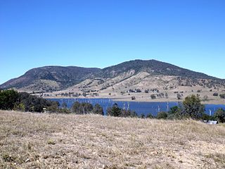
Lake Wivenhoe is the name both a lake formed by the Wivenhoe Dam and the locality which contains it in the Somerset Region, Queensland, Australia. In the 2016 census, Lake Wivenhoe had a population of three people.

<span class="mw-page-title-main">D'Aguilar Range</span> Mountain range in Australia

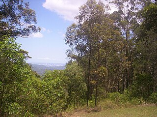
The D'Aguilar Range is a mountain range near Brisbane, Queensland, Australia. The town of Dayboro is situated on the lower foothills midway along the range and the Sunshine Coast Hinterland town of Mooloolah lies at the northernmost point of the range. Many residential areas line its eastern slopes including the town of Samford and the suburb of Ferny Hills. In the west, numerous ridges and gullies are heavily forested and designated as state forest or national park.

<span class="mw-page-title-main">Stanley River (Queensland)</span> River in Queensland, Australia

The Stanley River is a perennial river in the South East region of Queensland, Australia. A major tributary of the Brisbane River, the Stanley River valley extends roughly 35 kilometres (22 mi) westwards from the area south of Maleny, through Woodford to Kilcoy before veering southwards.

<span class="mw-page-title-main">Dayboro, Queensland</span> Town in Queensland, Australia

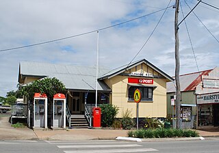
Dayboro is a rural town and locality in the City of Moreton Bay, Queensland, Australia. In the 2016 census, the locality of Dayboro had a population of 2,119 people.

<span class="mw-page-title-main">Lowood, Queensland</span> Town in Queensland, Australia

Lowood is a rural town and locality in the Somerset Region, Queensland, Australia. In the 2016 census, the locality of Lowood had a population of 4,159 people.

<span class="mw-page-title-main">Camp Mountain, Queensland</span> Suburb of City of Moreton Bay, Queensland, Australia

Camp Mountain is a rural locality in the City of Moreton Bay, Queensland, Australia. In the 2016 census, Camp Mountain had a population of 1,416 people.

<span class="mw-page-title-main">Fernvale, Queensland</span> Town in Queensland, Australia

Fernvale is a rural town and locality in the Somerset Region, Queensland, Australia. In the 2016 census, the locality of Fernvale had a population of 3,209 people.

<span class="mw-page-title-main">Somerset Region</span> Local government area in Queensland, Australia

The Somerset Region is a local government area located in the West Moreton region of South East Queensland, Australia, about 100 kilometres (62 mi) northwest of Brisbane and centred on the town of Esk. It was created in 2008 from a merger of the Shire of Esk and the Shire of Kilcoy. It is commonly known as the Brisbane Valley, due to the Brisbane River which courses through the region, although significant parts of the region lie outside the hydrological Brisbane Valley itself.

<span class="mw-page-title-main">Fairney View, Queensland</span> Suburb of Somerset Region, Queensland, Australia

Fairney View is a rural locality in the Somerset Region, Queensland, Australia. In the 2016 census, Fairney View had a population of 223 people.

<span class="mw-page-title-main">England Creek, Queensland</span> Rural locality split between the City of Brisbane and Somerset Region

England Creek is a rural locality split between Somerset Region and City of Brisbane, Queensland, Australia. In the 2016 census, England Creek had a population of 33 people.

<span class="mw-page-title-main">West Moreton</span> Region in Queensland, Australia

West Moreton is a region of the Australian state of Queensland, consisting of the entire rural western portion of South East Queensland. It sits inland from both the Brisbane metropolitan area and the Gold Coast and to the east of the Darling Downs. Much of the region lies in the Great Dividing Range. The name appears in the names of many community organisations and is used by the Australian Bureau of Statistics, although is not widely used otherwise due to the prevalence of South East Queensland in planning and other documents.

<span class="mw-page-title-main">Brisbane Valley Rail Trail</span> Rail trail in Queensland, Australia

The Brisbane Valley Rail Trail (BVRT) is a 161-kilometre (100 mi) recreation trail from Wulkuraka to Yarraman in Queensland, Australia. The trail follows the old Brisbane Valley railway line and is open to walkers, touring cyclists and horse riders. The trail details the history and landscape of the Brisbane Valley. It is the longest rail trail in Queensland.

<span class="mw-page-title-main">Coominya railway station</span> Railway station in Queensland, Australia

Coominya railway station is central to all activities in historic Coominya village, located in the Somerset Region of South East Queensland.

<span class="mw-page-title-main">Bryden, Queensland</span> Suburb of Somerset Region, Queensland, Australia

Bryden is a rural locality in the Somerset Region, Queensland, Australia. In the 2016 census, Bryden had a population of 33 people.

<span class="mw-page-title-main">Crossdale, Queensland</span> Suburb of Somerset Region, Queensland, Australia

Crossdale is a rural locality in the Somerset Region, Queensland, Australia. In the 2016 census, Crossdale had a population of 75 people.

<span class="mw-page-title-main">Rush Creek, Queensland</span> Suburb of City of Moreton Bay, Queensland, Australia

Rush Creek is a rural locality in the City of Moreton Bay, Queensland, Australia. In the 2016 census, Rush Creek had a population of 157 people.

<span class="mw-page-title-main">Split Yard Creek, Queensland</span> Suburb of Somerset Region, Queensland, Australia

Split Yard Creek is a rural locality in the Somerset Region, Queensland, Australia. In the 2016 census, Split Yard Creek had a population of 37 people.

<span class="mw-page-title-main">Wivenhoe Hill, Queensland</span> Suburb of Somerset Region, Queensland, Australia

Wivenhoe Hill is a locality in the Somerset Region, Queensland, Australia. In the 2016 census, Wivenhoe Hill had a population of 9 people.

References

  1. 1 2 3 Australian Bureau of Statistics (27 June 2017). "Dundas (SSC)". 2016 Census QuickStats. Retrieved 20 October 2018. OOjs UI icon edit-ltr-progressive.svg
  2. 1 2 "Dundas – locality in Somerset Region (entry 44862)". Queensland Place Names. Queensland Government . Retrieved 29 December 2020.
  3. "Boating and Fishing". Somerset Regional Council. Archived from the original on 2 February 2017. Retrieved 29 January 2017.
  4. Queensland Family History Society (2010), Queensland schools past and present (Version 1.01 ed.), Queensland Family History Society, ISBN   978-1-921171-26-0
  5. "Agency ID 1237, Police Station, Deep Creek". Queensland State Archives . Retrieved 13 April 2014.
  6. "Closed Anglican Churches". Anglican Church South Queensland. Archived from the original on 3 April 2019. Retrieved 29 June 2020.
  7. Australian Bureau of Statistics (31 October 2012). "Crossdale". 2011 Census QuickStats. Retrieved 11 April 2014. OOjs UI icon edit-ltr-progressive.svg
  8. "Queensland Globe". State of Queensland . Retrieved 5 February 2021.
  9. "Tourist points - Queensland". Queensland Open Data. Queensland Government. 18 November 2020. Archived from the original on 24 November 2020. Retrieved 24 November 2020.
  10. "Wivenhoe outlook | D'Aguilar National Park". Parks and forests. Queensland Government. 25 July 2019. Archived from the original on 22 October 2020. Retrieved 5 February 2021.