West Woombye, Queensland

Last updated

West Woombye
Sunshine Coast,  Queensland
Australia Queensland location map.svg
Red pog.svg
West Woombye
Coordinates 26°39′44″S152°55′34″E / 26.6622°S 152.9261°E / -26.6622; 152.9261 (West Woombye (centre of locality)) Coordinates: 26°39′44″S152°55′34″E / 26.6622°S 152.9261°E / -26.6622; 152.9261 (West Woombye (centre of locality))
Population1,007 (2016 census) [1]
 • Density86.8/km2 (224.8/sq mi)
Postcode(s) 4559
Area11.6 km2 (4.5 sq mi)
Time zone AEST (UTC+10:00)
Location
LGA(s) Sunshine Coast Region
State electorate(s) Nicklin
Federal division(s)
Suburbs around West Woombye:
Dulong Towen Mountain Coes Creek
Hunchy West Woombye Woombye
Hunchy Hunchy Palmwoods

West Woombye is a rural residential locality in the Sunshine Coast Region, Queensland, Australia. [2] In the 2016 census West Woombye had a population of 1,007 people. [1]

Contents

Geography

West Woombye is in the Sunshine Coast hinterland. As the name suggests, it is west of the town and locality of Woombye. The surrounding suburbs include Towen Mountain, Hunchy, Dulong, Palmwoods and Coes Creek. [3] There is farming within the area with crops such as lychees, macadamias, mangoes and avocados grown.[ citation needed ]

The main road running through West Woombye is Blackall Range Road. This road turns into Dulong Road once in the suburb of Dulong. As the area incorporates the Blackall Range leading up to Montville, the area is noted for its scenery. However, there are a number of notable creeks within area prone to flooding in heavy rain, primarily Petrie Creek. This mostly affects the roads off Blackall Range Road, such as Ruwoldt Road, Carruthers Road, and the Jackson Road area.[ citation needed ]

History

The name Woombye comes from the Kabi word wambai meaning black myrtle tree, which was used for handles for axes. [4]

In the 2016 census West Woombye had a population of 1,007 people. [1]

Education

There are no schools in West Woombye. The nearest government primary schools are Woombye State School in neighbouring Woombye to the east, Burnside State School in Burnside to the north, Mapleton State School in Mapleton to the north-west, and Montville State School in Montville to the south-west. The nearest government secondary schools are Burnside State High School in Burnside to the north and Nambour State College in Nambour to the north-east. [3]

Amenities

There are a number of parks in the locality, including:

Transport

There is no notable public transport in the area except the school bus runs and taxi. Depending on the starting point within West Woombye it takes about 5 to 7 minutes by vehicle into the Woombye township, 10 to 12 minutes to Nambour township and 5 to 7 minutes to Mapleton.[ citation needed ]

Related Research Articles

Nambour Suburb of Sunshine Coast, Queensland, Australia

Nambour is a rural town and locality in the Sunshine Coast Region, Queensland, Australia. In the 2016 census, the locality of Nambour had a population of 11,187 people.

Palmwoods, Queensland Suburb of Sunshine Coast, Queensland, Australia

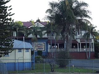
Palmwoods is a rural town and locality in the Sunshine Coast Region, Queensland, Australia. In the 2016 census, Palmwoods had a population of 5,676 people.

Mapleton, Queensland Suburb of Sunshine Coast Region, Queensland, Australia

Mapleton is a rural town and locality in the Sunshine Coast Region, Queensland, Australia. In the 2016 census, Mapleton had a population of 1,564 people.

Montville is a rural town and locality in the Sunshine Coast Region, Queensland, Australia. In the 2016 census, Montville had a population of 970 people.

Woombye, Queensland Town in Queensland, Australia

Woombye is a town and locality in the Sunshine Coast Region, Queensland, Australia. In the 2016 census, Woombye had a population of 3,246 people.

Electoral district of Nicklin State electoral district of Queensland, Australia

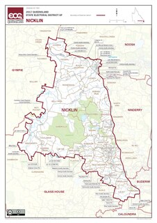
Nicklin is an electoral district of the Legislative Assembly in the Australian state of Queensland. The electorate is centred in the Sunshine Coast hinterland, and stretches north to Black Mountain, south to Palmwoods and Montville, and west to Kenilworth, including Conondale National Park. It includes notable localities such as Nambour, Yandina, Cooroy, Bli Bli, Mapleton and Woombye.

Eudlo is a rural town and locality in the Sunshine Coast Region, Queensland, Australia. In the 2016 census, the locality of Eudlo had a population of 1,117 people.

Diddillibah is a semi-rural locality in the Sunshine Coast Region, Queensland, Australia. In the 2016 census, Diddillibah had a population of 1,403 people.

Maroochy River, Queensland Suburb of Sunshine Coast Region, Queensland, Australia

Maroochy River is a rural hinterland locality in the Sunshine Coast Region, Queensland, Australia. In the 2016 census Maroochy River had a population of 1,531 people.

Ninderry, Queensland Town in Queensland, Australia

Ninderry is a rural town and locality in the Sunshine Coast Region, Queensland, Australia. In the 2016 census, the locality of Ninderry had a population of 1,087 people.

Burnside is a locality in the Sunshine Coast Region, Queensland, Australia. In the 2016 census, Burnside had a population of 2,409 people.

Kiels Mountain is a rural locality in the Sunshine Coast Region, Queensland, Australia. In the 2016 census, Kiels Mountain had a population of 664 people.

Blackall Range

The Blackall Range is a mountain range in South East Queensland, Australia. The first European explorer in the area was Ludwig Leichhardt. It was named after Samuel Blackall, the second Governor of Queensland.

Landers Shoot is a rural locality in the Sunshine Coast Region, Queensland, Australia. In the 2016 census, Landers Shoot had a population of 252 people.

Hunchy is a locality in the Sunshine Coast, Queensland, Australia. In the 2016 census, Hunchy had a population of 549 people.

Dulong is a rural locality in the Sunshine Coast Region, Queensland, Australia. In the 2016 census, Dulong had a population of 564 people.

Kureelpa is a locality in the Sunshine Coast Region, Queensland, Australia. In the 2016 census, Kureelpa had a population of 907 people.

Gheerulla is a rural locality in the Sunshine Coast Region, Queensland, Australia. In the 2016 census, Gheerulla had a population of 214 people.

The following details the year by year events for Sunshine Coast Football in Queensland, since the first recorded game on the North Coast in 1920.

References

  1. 1 2 3 Australian Bureau of Statistics (27 June 2017). "West Woombye (SSC)". 2016 Census QuickStats. Retrieved 20 October 2018. OOjs UI icon edit-ltr-progressive.svg
  2. "West Woombye – locality in Sunshine Coast Region (entry 50411)". Queensland Place Names. Queensland Government . Retrieved 29 December 2020.
  3. 1 2 "Queensland Globe". State of Queensland . Retrieved 16 May 2021.
  4. "Woombye – population centre in the Sunshine Coast Region (entry 38087)". Queensland Place Names. Queensland Government . Retrieved 16 May 2021.
  5. 1 2 3 4 "Land for public recreation – Queensland". Queensland Open Data. Queensland Government. 20 November 2020. Archived from the original on 22 November 2020. Retrieved 22 November 2020.