Dulong, Queensland

Last updated

Dulong
Queensland
Green country. Dulong Lookout, Sunshine coast, Australia (40926065122).jpg
Australia Queensland location map.svg
Red pog.svg
Dulong
Coordinates 26°38′24″S152°53′34″E / 26.64°S 152.8927°E / -26.64; 152.8927 (Dulong (centre of locality))
Population688 (SAL 2021) [1]
Postcode(s) 4560
Area11.2 km2 (4.3 sq mi)
Time zone AEST (UTC+10:00)
Location
LGA(s) Sunshine Coast Region
State electorate(s) Nicklin
Federal division(s) Fairfax
Suburbs around Dulong:
Mapleton Kureelpa Perwillowen
Mapleton Dulong Towen Mountain
Flaxton Hunchy West Woombye

Dulong is a rural locality in the Sunshine Coast Region, Queensland, Australia. [2] In the 2021 census, Dulong had a population of 688 people. [3]

Contents

Geography

The land use is a mixture of rural residential housing and grazing on native vegetation. There is a quarry from which basalt rock is extracted for use in the construction of roads and drainage. [4] [5]

History

The name Dulong is believed to be an Aboriginal word meaning mud or wet clay. [2]

Dulong Provisional School opened on 8 July 1895, becoming Dulong State School on 1 January 1909. It closed due to local attendances in 1929 but reopened in 1930. It closed permanently in 1967. [6] The school was located at the north-west corner of the intersection of Dulong School Road and Sherwell Road ( 26°38′10″S152°53′10″E / 26.6361°S 152.8861°E / -26.6361; 152.8861 (Dulong State School (former)) ). [7] [4]

Demographics

In the 2016 census, Dulong had a population of 564 people. [8]

In the 2021 census, Dulong had a population of 688 people. [3]

Education

There are no schools in Dulong. The nearest government primary schools are Mapleton State School in neighbouring Mapleton to the north-west and Burnside State School in Burnside to the east. The nearest government secondary school is Burnside State High School, also in Burnside. [4]

Attractions

Despite the name, the Dulong Lookout is on Dulong Road is just beyond the boundaries of the locality on the boundary of Kureelpa and Burnside ( 26°37′35″S152°54′46″E / 26.6264°S 152.9127°E / -26.6264; 152.9127 (Dulong Lookout) ). [9] [4] The view to the east overlooks Burnside, Nambour, and beyond to the Coral Sea. [10]

Notable residents

Related Research Articles

<span class="mw-page-title-main">Mapleton, Queensland</span> Suburb of Sunshine Coast Region, Queensland, Australia

Mapleton is a rural town and locality in the Sunshine Coast Region, Queensland, Australia. In the 2016 census, the locality of Mapleton had a population of 1,564 people.

<span class="mw-page-title-main">Eumundi, Queensland</span> Town in Queensland, Australia

Eumundi is a rural town and locality in the Sunshine Coast Region, Queensland, Australia. In the 2021 census, the locality of Eumundi had a population of 2,504 people.

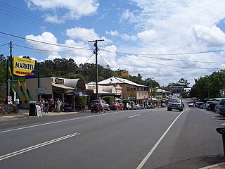
Montville is a rural town and locality in the Sunshine Coast Region, Queensland, Australia. In the 2016 census, the locality of Montville had a population of 970 people.

<span class="mw-page-title-main">Woombye, Queensland</span> Town in Queensland, Australia

Woombye is a rural town and locality in the Sunshine Coast Region, Queensland, Australia. In the 2021 census, the locality of Woombye had a population of 3,944 people.

Ridgewood is a rural locality in the Shire of Noosa, Queensland, Australia. In the 2021 census, Ridgewood had a population of 317 people.

Cootharaba is a rural locality in the Shire of Noosa, Queensland, Australia. In the 2021 census, Cootharaba had a population of 866 people.

<span class="mw-page-title-main">Burnside, Queensland</span> Suburb of Nambour, Queensland, Australia

Burnside is a residential locality of the town of Nambour in the Sunshine Coast Region, Queensland, Australia. In the 2021 census, Burnside had a population of 3,104 people.

Coes Creek is a rural locality in the Sunshine Coast Region, Queensland, Australia. In the 2021 census, Coes Creek had a population of 1,515 people.

West Woombye is a rural residential locality in the Sunshine Coast Region, Queensland, Australia. In the 2016 census West Woombye had a population of 1,007 people.

Chevallum is a rural locality in the Sunshine Coast Region, Queensland, Australia. In the 2016 census, Chevallum had a population of 441 people. In the 2021 census, Chevallum had a population of 467 people.

<span class="mw-page-title-main">Coochin Creek</span> Suburb of Sunshine Coast, Queensland, Australia

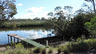
Coochin Creek is a coastal locality in the south of the Sunshine Coast Region, Queensland, Australia. The locality is named for the creek which flows through it.

Hunchy is a rural locality in the Sunshine Coast, Queensland, Australia. In the 2021 census, Hunchy had a population of 592 people.

<span class="mw-page-title-main">Obi Obi, Queensland</span> Suburb of Sunshine Coast Region, Queensland, Australia

Obi Obi is a rural locality in the Sunshine Coast Region, Queensland, Australia. In the 2021 census, Obi Obi had a population of 208 people.

Bald Knob is a rural locality in the Sunshine Coast Region, Queensland, Australia. At the 2021 census, Bald Knob had a population of 280 people.

<span class="mw-page-title-main">Balmoral Ridge, Queensland</span> Suburb of Sunshine Coast, Queensland, Australia

Balmoral Ridge is a rural locality in the Sunshine Coast Region, Queensland, Australia. At the 2021 census, Balmoral Ridge had a population of 302 people.

<span class="mw-page-title-main">Flaxton, Queensland</span> Suburb of Sunshine Coast Region, Queensland, Australia

Flaxton is a rural locality in the Sunshine Coast Region, Queensland, Australia. In the 2021 census, Flaxton had a population of 992 people.

<span class="mw-page-title-main">Witta, Queensland</span> Suburb of Sunshine Coast Region, Queensland, Australia

Witta is a rural town and locality in the Sunshine Coast Region, Queensland, Australia. In the 2021 census, the locality of Witta had a population of 1,296 people.

Kureelpa is a rural locality in the Sunshine Coast Region, Queensland, Australia. In the 2021 census, Kureelpa had a population of 968 people.

Perwillowen is a rural locality in the Sunshine Coast Region, Queensland, Australia. In the 2021 census, Perwillowen had a population of 213 people.

Gheerulla is a rural locality in the Sunshine Coast Region, Queensland, Australia. In the 2016 census, Gheerulla had a population of 214 people.

References

  1. Australian Bureau of Statistics (28 June 2022). "Dulong (Suburb and Locality)". Australian Census 2021 QuickStats. Retrieved 28 June 2022.  OOjs UI icon edit-ltr-progressive.svg
  2. 1 2 "Dulong – locality in Sunshine Coast Region (entry 48612)". Queensland Place Names. Queensland Government . Retrieved 5 November 2019.
  3. 1 2 Australian Bureau of Statistics (28 June 2022). "Dulong (SAL)". 2021 Census QuickStats. Retrieved 28 February 2023. OOjs UI icon edit-ltr-progressive.svg
  4. 1 2 3 4 "Queensland Globe". State of Queensland . Retrieved 8 August 2023.
  5. Witsenhuysen, Francis (3 January 2023). "Future of council's quarries revealed". Sunshine Coast News. Retrieved 8 August 2023.
  6. Queensland Family History Society (2010), Queensland schools past and present (Version 1.01 ed.), Queensland Family History Society, ISBN   978-1-921171-26-0
  7. "Parish of Maroochy sheet 2" (Map). Queensland Government. 1965. Archived from the original on 17 October 2021. Retrieved 17 October 2021.
  8. Australian Bureau of Statistics (27 June 2017). "Dulong (SSC)". 2016 Census QuickStats. Retrieved 20 October 2018. OOjs UI icon edit-ltr-progressive.svg
  9. "Tourist points - Queensland". Queensland Open Data. Queensland Government. 18 November 2020. Archived from the original on 24 November 2020. Retrieved 24 November 2020.
  10. Cantori, Lucy (13 April 2016). "Dulong Lookout to get $300,000 upgrade". Sunshine Coast Daily . Retrieved 30 July 2023.