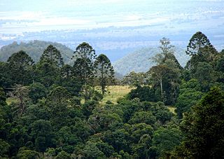
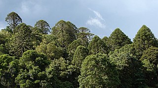
Wengenville

Last updated

Wengenville
Queensland
StateLibQld 2 393245 Horse grazing near Munro's Camp, Bunya Mountains, 1929.jpg
Horse grazing near Munro's Camp, 1929
Australia Queensland location map.svg
Red pog.svg
Wengenville
Coordinates 26°49′39″S151°41′14″E / 26.8275°S 151.6872°E / -26.8275; 151.6872 (Wengenville (centre of locality))
Postcode(s) 4615
Area115.7 km2 (44.7 sq mi)
Time zone AEST (UTC+10:00)
Location
LGA(s) South Burnett Region
State electorate(s) Nanango
Federal division(s) Maranoa
Suburbs around Wengenville:
Alice Creek Alice Creek Ellesmere
Bunya Mountains Wengenville Maidenwell
Brooklands
Bunya Mountains Pimpimbudgee Pimpimbudgee

Wengenville is a rural locality in the South Burnett Region, Queensland, Australia. [1] In the 2021 census, Wengenville had a population of 54 people. [2]

Contents

Geography

The Maidenwell Bunya Mountain Road, one of three ways to access the Bunya Mountains by road, passes through the locality from east to south. [3]

The terrain varies from 410 to 800 metres (1,350 to 2,620 ft) above sea level. The land use is predominantly grazing on native vegetation with a small amount of crop-growing. There is a pocket of rural residential housing in the south-east of the locality near the Bunya Mountains. [4]

History

The locality's name is derived from Wengen Creek, which probably comes from the Waka language (Bujiebara dialect) word wingin, which comes from the local Indigenous culture involving an old woman whose name was Winyirgan.

Wengenville was probably named at the suggestion of the daughter-in-law of sawmiller Lars Andersen, when the mill was erected on the site. The Bunya Timber Mills were started in 1923 and by August 1924, employed 56 men. [5] [6] A mountain tramway which fed logs to the mill had at its steepest a gradient of 1 in 1.5. [7] [8] The descent was accomplished by a winder known as a gravitation plant. [9]

A postal receiving office was opened at the Bunya Cash Store in August 1929, and then Wengenville was the name given to the post office at Bunya Mills in November 1929. [10] Henceforth all mail sent to that part of the district was to be addressed "Wengenville, via Maidenwell." [11]

The mill closed in 1961 and shortly afterwards the township was abandoned . [1] [12]

Maidenwell Provisional School opened in April 1926. In 1934, a new school building was constructed and was opened as Wengenville State School. It closed in 1961. [13] It was at 3 Wengen Creek Road (eastern corner with Maidenwell Bunya Mountains Road, 26°50′17″S151°41′57″E / 26.83813°S 151.69908°E / -26.83813; 151.69908 (Wengenville State School (former)) ). [14] [15]

Demographics

In the 2016 census, Wengenville had a population of 46 people. [16]

In the 2021 census, Wengenville had a population of 54 people. [2]

Education

There are no schools in Wengenville. The nearest government primary schools are Tanduringie State School in neighouring Pimpimbudgee to the south-east and Kumbia State School in Kumbia to the north. [17] The nearest government secondary schools are: [17]

See also

Related Research Articles

<span class="mw-page-title-main">Dalby, Queensland</span> Town in Queensland, Australia

Dalby is a rural town and locality in the Western Downs Region, Queensland, Australia. In the 2021 census, the locality of Dalby had a population of 12,082 people.

<span class="mw-page-title-main">Yarraman, Queensland</span> Town in Queensland, Australia

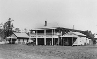
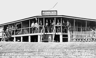
Yarraman is a rural town and locality in the Toowoomba Region, Queensland, Australia. In the 2021 census, the locality of Yarraman had a population of 1,127 people.
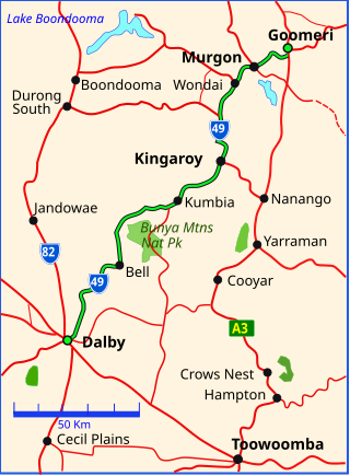
<span class="mw-page-title-main">Kingsthorpe, Queensland</span> Town in Queensland, Australia

Kingsthorpe is a rural town and locality in the Toowoomba Region, Queensland, Australia. In the 2021 census, the locality of Kingsthorpe had a population of 2,159 people.

Moola is a rural locality in the Western Downs Region, Queensland, Australia. In the 2016 census Moola had a population of 123 people.

<span class="mw-page-title-main">Quinalow</span> Town in Queensland, Australia

Quinalow is a rural town and locality in the Toowoomba Region, Queensland, Australia. In the 2016 census the locality of Quinalow had a population of 173 people.

<span class="mw-page-title-main">Mount Lofty, Queensland</span> Suburb of Toowoomba, Queensland, Australia

Mount Lofty is a residential locality on the north-eastern edge of the suburban area of Toowoomba, in the Toowoomba Region, Queensland, Australia. In the 2016 census, Mount Lofty had a population of 3,775 people.

Maidenwell is a rural town and locality in the South Burnett Region, Queensland, Australia. In the 2016 census, the locality of Maidenwell had a population of 199 people.

<span class="mw-page-title-main">Geham</span> Suburb of Toowoomba Region, Queensland, Australia

Geham is a rural locality in the Toowoomba Region, Queensland, Australia. In the 2021 census, Geham had a population of 470 people.

<span class="mw-page-title-main">Maclagan, Queensland</span> Town in Queensland, Australia

Maclagan is a rural town and locality in the Toowoomba Region, Queensland, Australia. In the 2016 census the locality of Maclagan had a population of 195 people.

<span class="mw-page-title-main">Upper Yarraman, Queensland</span> Suburb of Toowoomba Region, Queensland, Australia

Upper Yarraman is a rural locality in the Toowoomba Region, Queensland, Australia. In the 2016 census, Upper Yarraman had a population of 104 people.

<span class="mw-page-title-main">Mount Irving, Queensland</span> Suburb of Toowoomba Region, Queensland, Australia

Mount Irving is a rural locality in the Toowoomba Region, Queensland, Australia. In the 2021 census, Mount Irving had a population of 34 people.

Pimpimbudgee is a rural locality in the South Burnett Region, Queensland, Australia. In the 2016 census Pimpimbudgee had a population of 72 people.

Umbiram is a rural locality in the Toowoomba Region, Queensland, Australia. In the 2016 census, Umbiram had a population of 139 people.

<span class="mw-page-title-main">Western Creek, Queensland</span> Suburb of Toowoomba Region, Queensland, Australia

Western Creek is a locality in the Toowoomba Region, Queensland, Australia. In the 2021 census, Western Creek had "no people or a very low population".

<span class="mw-page-title-main">Mowbullan, Queensland</span> Suburb of Western Downs Region, Queensland, Australia

Mowbullan is a rural locality in the Western Downs Region, Queensland, Australia. In the 2021 census, Mowbullan had a population of 12 people.

Emu Creek is a rural locality in the Toowoomba Region, Queensland, Australia. In the 2021 census, Emu Creek had a population of 113 people.

Narko is a rural locality in the Toowoomba Region, Queensland, Australia. In the 2021 census, Narko had a population of 16 people.

The roads that join the towns of Dalby, Oakey and Cooyar form a triangle that encloses some of the most fertile land on the Darling Downs in Queensland, Australia. These roads are the Warrego Highway, Oakey–Cooyar Road and Dalby–Cooyar Road. Several of the more significant internal roads intersect with Dalby–Cooyar Road, and these are briefly described in this article, along with some significant external roads.

The roads that join the towns of Dalby, Toowoomba and Cooyar form a triangle that encloses some of the most fertile land on the Darling Downs in Queensland, Australia. These roads are the Warrego Highway, New England Highway and Dalby–Cooyar Road. Pechey–Maclagan Road forms a large part of a group of roads that bisect the triangle from east to west, and is also part of one of the groups of roads that bisect from south to north.

Bunya Mountains road network is a group of roads that provide access to the mountain community from various lowland localities. The network ensures continuity of access in times of flooding or other natural disasters, and during planned maintenance activities. The locality of Bunya Mountains includes the Bunya Mountains National Park and the enclosed locality of Mowbullan. The area hosts a small residential community plus many tourism accommodation venues.

References

  1. 1 2 "Wengenville – locality in South Burnett Region (entry 46277)". Queensland Place Names. Queensland Government . Retrieved 29 December 2020.
  2. 1 2 Australian Bureau of Statistics (28 June 2022). "Wengenville (SAL)". 2021 Census QuickStats. Retrieved 28 February 2023. OOjs UI icon edit-ltr-progressive.svg
  3. Google (29 July 2019). "Wengenville, Queensland" (Map). Google Maps . Google. Retrieved 29 July 2019.
  4. "Layers: Locality; Protected areas and forests; Land use; Land parcel". Queensland Globe. Queensland Government. Archived from the original on 19 December 2017. Retrieved 31 March 2024.
  5. "COOYAR". Toowoomba Chronicle and Darling Downs Gazette . Vol. LXII, no. 113. Queensland, Australia. 12 May 1923. p. 13. Archived from the original on 15 December 2023. Retrieved 22 August 2023 via National Library of Australia.
  6. "MAIDENWELL DISTRICT". Toowoomba Chronicle and Darling Downs Gazette . Vol. LXIII, no. 191. Queensland, Australia. 11 August 1924. p. 8. Archived from the original on 15 December 2023. Retrieved 20 August 2023 via National Library of Australia.
  7. "MAIDENWELL DISTRICT". Toowoomba Chronicle and Darling Downs Gazette . Vol. LXV, no. 51. Queensland, Australia. 1 March 1926. p. 8. Archived from the original on 15 December 2023. Retrieved 20 August 2023 via National Library of Australia.
  8. Kerr, John (January 1998). "Inventory of Sawmills and Tramways" (PDF). Queensland Government . pp. 187, 188. Archived (PDF) from the original on 15 May 2021. Retrieved 22 August 2023.
  9. "IN THE HEART OF THE HILLS". The Queenslander . No. 5997. Queensland, Australia. 27 March 1926. p. 11. Archived from the original on 15 December 2023. Retrieved 21 August 2023 via National Library of Australia.
  10. "DISTRICT NEWS". Toowoomba Chronicle and Darling Downs Gazette . Vol. LXVIII, no. 194. Queensland, Australia. 15 August 1929. p. 8. Archived from the original on 15 December 2023. Retrieved 21 August 2023 via National Library of Australia.
  11. "DISTRICT NEWS". Toowoomba Chronicle and Darling Downs Gazette . Vol. LXVIII, no. 188. Queensland, Australia. 2 December 1929. p. 8. Archived from the original on 15 December 2023. Retrieved 20 August 2023 via National Library of Australia.
  12. Berry, Julie (20 June 2022). "Where's Wengenville?". Burnett Today. Archived from the original on 21 August 2023. Retrieved 21 August 2023.
  13. Queensland Family History Society (2010), Queensland schools past and present (Version 1.01 ed.), Queensland Family History Society, ISBN   978-1-921171-26-0
  14. "Queensland Two Mile series sheet 2m78" (Map). Queensland Government. 1951. Archived from the original on 15 December 2023. Retrieved 15 December 2023.
  15. "Queensland Globe". State of Queensland . Retrieved 15 December 2023.
  16. Australian Bureau of Statistics (27 June 2017). "Wengenville (SSC)". 2016 Census QuickStats. Retrieved 20 October 2018. OOjs UI icon edit-ltr-progressive.svg
  17. 1 2 "Layers: Locality; Schools and school catchments". Queensland Globe. Queensland Government. Archived from the original on 19 December 2017. Retrieved 31 March 2024.

Further reading