
The Northern Territory is an Australian territory in the central and central northern regions of Australia. The Northern Territory shares its borders with Western Australia to the west, South Australia to the south, and Queensland to the east. To the north, the territory looks out to the Timor Sea, the Arafura Sea and the Gulf of Carpentaria, including Western New Guinea and other islands of the Indonesian archipelago.
The protected areas of the Northern Territory consists of protected areas managed by the governments of the Northern Territory and Australia and private organisations with a reported total area of 335,527 square kilometres (129,548 sq mi) being 24.8% of the total area of the Northern Territory of Australia.
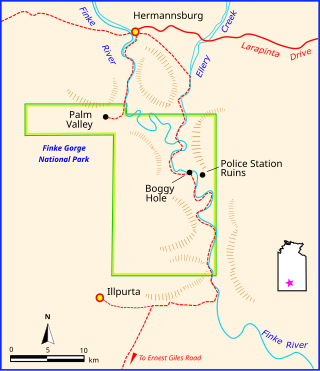
Finke Gorge National Park is a protected area in the Northern Territory of Australia located about 1,318 kilometres (819 mi) south of the territory capital of Darwin. The national park covers an area of 458 km2 (177 sq mi), and includes the impressive desert oasis Palm Valley, home to a diverse range of plant species, many of which are rare and unique to the area. There are good opportunities for bushwalking and bushcamping in the national park.
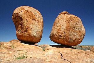
Karlu Karlu / Devils Marbles Conservation Reserve is a protected area in the Northern Territory of Australia located in the locality of Warumungu about 105 km (65 mi) south of Tennant Creek, and 393 km (244 mi) north of Alice Springs. The nearest settlement is the small town of Wauchope located 9 km (5.6 mi) to the south.
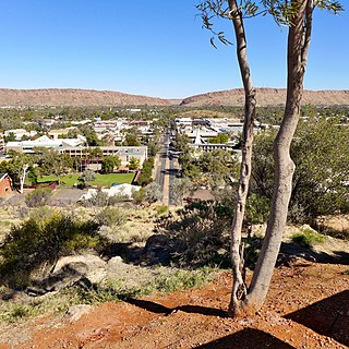
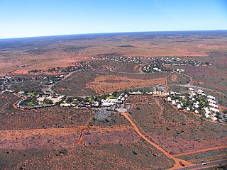
Alice Springs, is the third-largest town in the Northern Territory, Australia. The name Alice Springs was given by surveyor William Whitfield Mills after Alice, Lady Todd, wife of the telegraph pioneer Sir Charles Todd. Known colloquially as 'The Alice' or simply 'Alice', the town is situated roughly in Australia's geographic centre. It is nearly equidistant from Adelaide and Darwin.

Katherine is a town in the Northern Territory of Australia. It is situated on the Katherine River, after which it is named, 320 kilometres (200 mi) southeast of Darwin. It is the fourth largest settlement in the Territory and is known as the place where "The outback meets the tropics". Katherine had an urban population of approximately 6,300 at the 2016 Census.
Yulara is a town in the southern region of the Northern Territory, Australia. It lies as an unincorporated enclave within MacDonnell Region. At the 2016 census, Yulara had a permanent population of 1,099, in an area of 103.33 square kilometres (39.90 sq mi). It is 18 kilometres (11 mi) by road from World Heritage Site Uluru and 55 kilometres (34 mi) from Kata Tjuta. It is located in the Northern Territory electorate of Gwoja and the federal electorate of Lingiari.
The MacDonnell Ranges, or Tjoritja in Arrernte, is a mountain range located in southern Northern Territory. MacDonnell Ranges is also the name given to an interim Australian bioregion broadly encompassing the mountain range, with an area of 3,929,444 hectares. The range is a 644 km (400 mi) long series of mountains in central Australia, consisting of parallel ridges running to the east and west of Alice Springs. The mountain range contains many spectacular gaps and gorges as well as areas of Aboriginal significance.
Chambers Pillar is a sandstone formation some 160 km (100 mi) south of Alice Springs in the Northern Territory of Australia.
The Sandover Highway is an outback unsealed track in the Northern Territory between the Plenty Highway north of Alice Springs and the Northern Territory/Queensland border.
Victoria River is a locality in the Northern Territory of Australia located about 450 kilometres (280 mi) south of the territory capital of Darwin and about 240 kilometres (150 mi) south of the municipal seat in Katherine.
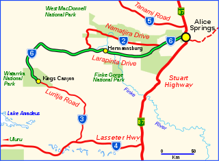
Larapinta Drive is a designated state route in the Northern Territory of Australia.

Arltunga is a deserted gold rush town located in the Northern Territory of Australia in the locality of Hart about 110 kilometres (68 mi) east of Alice Springs. It is of major historical significance as the first major European settlement in Central Australia.

Saleh "Charlie" Sadadeen, sometimes spelt Sadadene, was an Afghan cameleer and bushman who lived in Alice Springs in the Northern Territory of Australia.

Trephina Gorge is a gorge in the Northern Territory of Australia located in the locality of Hart in the East MacDonnell Ranges about 85 kilometres (53 mi) east of Alice Springs.
Ryan Well Historical Reserve, formerly Reserve No. 1343, is a protected area in the Northern Territory of Australia located in the locality of Anmatjere about 129 kilometres (80 mi) north of Alice Springs.
Kilgariff is a suburb of Alice Springs located in the Northern Territory of Australia about 1,290 kilometres (800 mi) south of the territory capital of Darwin and about 7 kilometres (4.3 mi) south of the municipal seat in the Alice Springs central business district. Kilgariff is located within the federal division of Lingiari, the territory electoral division of Braitling and the local government area of the Town of Alice Springs.

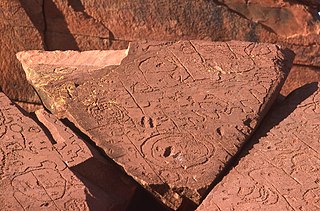
N'Dhala Gorge Nature Park is a protected area in the Northern Territory of Australia consisting of an area of low sand dunes, rocky outcrops, about 90 kilometres (56 mi) east of Alice Springs. It is significant principally because of thousands of Indigenous rock carvings.
Ah Hong was a Chinese market gardener who spent most of his life in Alice Springs, and was a well regarded figure in an era of considerable prejudice towards Chinese people in Australia.
Hart is a locality in the Northern Territory of Australia located in the territory's south-east about 1,259 kilometres (782 mi) south of the territory capital of Darwin.