Corroboree Rock Conservation Reserve

Last updated

Corroboree Rock Conservation Reserve
Northern Territory
IUCN category V (protected landscape/seascape) [1]
Corroboree rock.JPG
Corroboree Rock
Australia Northern Territory relief location map.png
Red pog.svg
Corroboree Rock Conservation Reserve
Coordinates 23°40′52″S134°12′57″E / 23.68111°S 134.21583°E / -23.68111; 134.21583 Coordinates: 23°40′52″S134°12′57″E / 23.68111°S 134.21583°E / -23.68111; 134.21583
Established1962 [1]
Area7 hectares (17 acres) [1]
Visitation15,000 (in 2011) [2]
Managing authorities Parks and Wildlife Commission of the Northern Territory
See also Protected areas of the Northern Territory

Corroboree Rock Conservation Reserve is a protected area in the Northern Territory of Australia.

Protected area location which receives protection because of its recognised natural, ecological or cultural landscape values

Protected areas or conservation areas are locations which receive protection because of their recognized natural, ecological or cultural values. There are several kinds of protected areas, which vary by level of protection depending on the enabling laws of each country or the regulations of the international organizations involved.

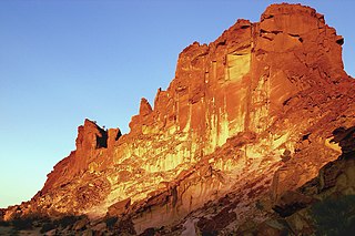
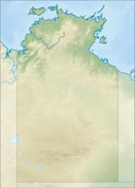
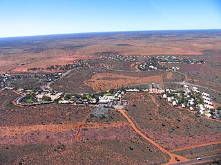
It is located approximately 34 kilometres (21 mi) east of Alice Springs and 370 kilometres (230 mi) north east of Yulara in the East MacDonnell Ranges. The reserve is surrounded by the Undoolya pastoral lease which operates as a cattle station.

Yulara, Northern Territory Town in the Northern Territory, Australia

Yulara is a town in the Southern Region of the Northern Territory, Australia. It lies as an unincorporated enclave within MacDonnell Region. At the 2016 census, Yulara had a permanent population of 1,099, in an area of 103.33 square kilometres (39.90 sq mi). It is 18 kilometres (11 mi) by road from world heritage site Uluru and 55 kilometres (34 mi) from Kata Tjuta. It is located in the Northern Territory electorate of Namatjira and the federal electorate of Lingiari.

MacDonnell Ranges the Northern Territory, Australia

The MacDonnell Ranges, a mountain range and an interim Australian bioregion, is located in the Northern Territory and has an area of 3,929,444 hectares. The range is a 644 km (400 mi) long series of mountains in central Australia, consisting of parallel ridges running to the east and west of Alice Springs. The mountain range contains many spectacular gaps and gorges as well as areas of Aboriginal significance.

Cattle station large Australian farm (station, the equivalent of an American ranch), whose main activity is the rearing of cattle

In Australia, a cattle station is a large farm, the main activity of which is the rearing of cattle. The owner of a cattle station is called a grazier. The largest cattle station in the world is Anna Creek Station in South Australia, which covers an area of 23,677 square kilometres.

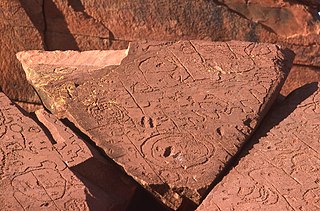
The reserve takes its name from a column of grey dolomite of great significance to the local Aboriginal people. The rock is part of the Bitter Springs formation that was deposited in salt lakes 800 million years ago. [3] It is a sacred site to the Eastern Arrente peoples

Dolomite (rock) Sedimentary carbonate rock that contains a high percentage of the mineral dolomite

Dolomite (also known as dolostone, dolomite rock or dolomitic rock) is a sedimentary carbonate rock that contains a high percentage of the mineral dolomite, CaMg(CO3)2. In old USGS publications, it was referred to as magnesian limestone, a term now reserved for magnesium-deficient dolomites or magnesium-rich limestones. Dolomite has a stoichiometric ratio of nearly equal amounts of magnesium and calcium. Most dolomites formed as a magnesium replacement of limestone or lime mud before lithification. Dolomite is resistant to erosion and can either contain bedded layers or be unbedded. It is less soluble than limestone in weakly acidic groundwater, but it can still develop solution features (karst) over time. Dolomite can act as an oil and natural gas reservoir.

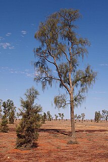
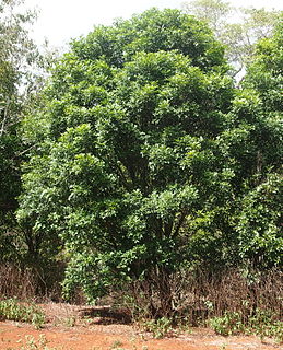
Flora found on the reserve include spinifex and senna on the ridges, with bloodwood, Supplejack, Red Mallee and Whitewood are found around the base of the rock. [3]

<i>Eucalyptus</i> genus of plants

Eucalyptus is a genus of over seven hundred species of flowering trees, shrubs or mallees in the myrtle family, Myrtaceae. Along with other genera in the tribe Eucalypteae, they are commonly known as eucalypts. Plants in the genus Eucalyptus have bark that is either smooth, fibrous, hard or stringy, leaves with oil glands, and sepals and petals that are fused to form a "cap" or operculum over the stamens. The fruit is a woody capsule commonly referred to as a "gumnut".

<i>Ventilago viminalis</i> species of plant

Ventilago viminalis, commonly known as Supplejack, Vine Tree or whip vine, is a tree native to Northern and Central Australia from coastal regions of Queensland to the central deserts of the Northern Territory.

<i>Atalaya</i> (plant) genus of plants

Atalaya is a genus of eighteen species of trees and shrubs of the plant family Sapindaceae. As of 2013 fourteen species grow naturally in Australia and in neighbouring New Guinea only one endemic species is known to science. Three species are known growing naturally in southern Africa, including two species endemic to South Africa and one species in South Africa, Swaziland and Mozambique.

See also

Protected areas of the Northern Territory

Related Research Articles

The protected areas of the Northern Territory consists of protected areas managed by the governments of the Northern Territory and Australia and private organisations with a reported total area of 335,527 square kilometres (129,548 sq mi) being 24.8% of the total area of the Northern Territory of Australia.

Karlu Karlu / Devils Marbles Conservation Reserve Protected area in the Northern Territory, Australia

Karlu Karlu / Devils Marbles Conservation Reserve is a protected area in the Northern Territory of Australia located in the locality of Warumungu about 105 km (65 mi) south of Tennant Creek, and 393 km (244 mi) north of Alice Springs. The nearest settlement is the small town of Wauchope located 9 km (5.6 mi) to the south.

Munga-Thirri—Simpson Desert Conservation Park Protected area in South Australia

Munga-Thirri—Simpson Desert Conservation Park is a protected area located in the Australian state of South Australia about 970 kilometres (600 mi) north of the state capital of Adelaide and above 215 kilometres (134 mi) north-east of the town of Oodnadatta.

Ewaninga Rock Carvings Conservation Reserve Protected area in the Northern Territory, Australia

The Ewaninga Conservation Reserve is a protected area in the Northern Territory of Australia consisting of an area of low sand dunes, rocky outcrops and a claypan about 35 kilometres (22 mi) south of Alice Springs. It is significant because of a large number of Indigenous rock carvings.

Mary River (Northern Territory) river in the Northern Territory, Australia

The Mary River flows in the Northern Territory of Australia and is a site of the Mary River National Park.

Rainbow Valley Conservation Reserve Protected area in the Northern Territory, Australia

Rainbow Valley Conservation Reserve is a protected area located south of Alice Springs, Northern Territory in Australia. The reserve was established in 1990 to protect the unique sandstone formations and the Aboriginal art, artifacts and sacred natural objects within an area of 24.83 km2 (9.59 sq mi) around a large sandstone bluff. The sandstone layers in the main formation resemble the coloured stripes of a rainbow, with the red-orange hues of sandstone that is rich with iron creating a strong contrast with the lighter shaded sandstone that turns pale yellow or gold in the late day sun as it shines on the northwest-facing cliffs.

Bullwaddy Conservation Reserve Protected area in the Northern Territory, Australia

The Bullwaddy Conservation Reserve is a protected area approximately 120 km (75 mi) north east of Elliott in the Northern Territory of Australia.

Shoal Bay Coastal Reserve Protected area in the Northern Territory, Australia

Shoal Bay Coastal Reserve is a coastal reserve in the Northern Territory of Australia.

Annas Reservoir Conservation Reserve Protected area in the Northern Territory, Australia

Anna's Reservoir Conservation Reserve is a protected area in the Northern Territory of Australia.

Blackmore River Conservation Reserve Protected area in the Northern Territory, Australia

Blackmore River Conservation Reserve is a protected area in the Northern Territory of Australia.

Caranbirini Conservation Reserve Protected area in the Northern Territory, Australia

Caranbirini Conservation Reserve is a protected area in the Northern Territory of Australia.

Connells Lagoon Conservation Reserve Protected area in the Northern Territory, Australia

Connells Lagoon Conservation Reserve also known as Dalgajini is a protected area in the Northern Territory of Australia.

Illamurta Springs Conservation Reserve Protected area in the Northern Territory, Australia

Illamurta Springs Conservation Reserve is a protected area in the Northern Territory of Australia in the locality of Ghan about 42 kilometres (26 mi) south of Hermannsburg and 140 kilometres (87 mi) west of Alice Springs. The southern foothills of the James Range and the permanent spring from which the reserve takes its name are found within the reserve.

Kintore Caves Conservation Reserve Protected area in the Northern Territory, Australia

Kintore Caves Conservation Reserve is a protected area in the Northern Territory of Australia.

Kuyunba Conservation Reserve Protected area in the Northern Territory, Australia

Kuyunba Conservation Reserve is a protected area in the Northern Territory of Australia.

Andado Cattle station in the Northern Territory of Australia

Andado Station is a pastoral lease that operates as a cattle station in the Alice Springs region of the Northern Territory. The traditional lands of the Arrernte people before European settlement, the first pastoral lease was granted in 1880. The station includes the Mac Clark Conservation Reserve, created to help preserve the rare Acacia peuce tree.

Mac Clark (Acacia peuce) Conservation Reserve Protected area in the Northern Territory, Australia

Mac Clark Conservation Reserve is a protected area in the Northern Territory of Australia located in the locality of Ghan.

Native Gap Conservation Reserve Protected area in the Northern Territory, Australia

Native Gap Conservation Reserve is a protected area in the Northern Territory of Australia.

Hann Range mountains in Australia

Hann Range is a mountain range in central Australia located approximately 120 kilometres (75 mi) north of Alice Springs in the Northern Territory.

Vernon Islands Conservation Reserve Protected area in the Northern Territory, Australia

Vernon Islands Conservation Reserve is a protected area in the Northern Territory of Australia located in the locality of Vernon Islands about 50 kilometres (31 mi) north-east of the territory capital of Darwin.

References

  1. 1 2 3 "Terrestrial Protected Areas by Reserve Type in the Northern Territory (2012)". Department of Environment. 2012. Retrieved 11 April 2015.
  2. "Corroboree Rock Conservation Reserve - Joint Management Plan" (PDF). Northern Territory Government. 1 October 2011. Archived from the original (PDF) on 23 March 2015. Retrieved 11 April 2015.
  3. 1 2 "Corroboree Rock Conservation Reserve". Parks and Wildlife Commission. Retrieved 11 April 2015.