
Highways in Australia are generally high capacity roads managed by state and territory government agencies, though Australia's federal government contributes funding for important links between capital cities and major regional centres. Prior to European settlement, the earliest needs for trade and travel were met by narrow bush tracks, used by tribes of Indigenous Australians. The formal construction of roads began in 1788, after the founding of the colony of New South Wales, and a network of three major roads across the colony emerged by the 1820s. Similar road networks were established in the other colonies of Australia. Road construction programs in the early 19th century were generally underfunded, as they were dependent on government budgets, loans, and tolls; while there was a huge increase in road usage, due to the Australian gold rushes. Local government authorities, often known as Road Boards, were therefore established to be primarily responsible for funding and undertaking road construction and maintenance. The early 1900s saw both the increasingly widespread use of motorised transportation, and the creation of state road authorities in each state, between 1913 and 1926. These authorities managed each state's road network, with the main arterial roads controlled and maintained by the state, and other roads remaining the responsibility of local governments. The federal government became involved in road funding in the 1920s, distributing funding to the states. The depression of the 1930s slowed the funding and development of the major road network until the onset on World War II. Supply roads leading to the north of the country were considered vital, resulting in the construction of Barkly, Stuart, and Eyre Highways.

The Sturt Highway is an Australian national highway in New South Wales, Victoria, and South Australia. The Sturt Highway is an important road link for the transport of passengers and freight between Sydney and Adelaide and the regions situated adjacent to the route.
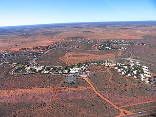
Yulara is a town in the southern region of the Northern Territory, Australia. It lies as an unincorporated enclave within MacDonnell Region. At the 2016 census, Yulara had a permanent population of 1,099, in an area of 103.33 square kilometres (39.90 sq mi). It is 18 kilometres (11 mi) by road from world heritage site Uluru and 55 kilometres (34 mi) from Kata Tjuta. It is located in the Northern Territory electorate of Gwoja and the federal electorate of Lingiari.

The Capricorn Highway is located in Central Queensland, Australia, and links the city of Rockhampton with western Queensland. The highway is 575 kilometres long, and joins the Landsborough Highway at Barcaldine. Formerly National Route 66, Queensland began to convert to the alphanumeric system much of Australia had adopted in the early-2000s and is now designated as A4. The highway runs parallel with the Tropic of Capricorn, hence its name.

Great Northern Highway is an Australian highway that links Western Australia's capital city Perth with its northernmost port, Wyndham. With a length of almost 3,200 kilometres (2,000 mi), it is the longest highway in Australia, with the majority included as part of the Perth Darwin National Highway. The highway is constructed as a sealed, predominantly two-lane single carriageway, but with some single-lane bridges in the Kimberley. The Great Northern Highway travels through remote areas of the state, and is the only sealed road link between the Northern Territory and northern Western Australia. Economically, it provides vital access through the Wheatbelt and Mid West to the resource-rich regions of the Pilbara and Kimberley. In these areas, the key industries of mining, agriculture and pastoral stations, and tourism are all dependent on the highway.

The Victoria Highway links the Great Northern Highway in Western Australia with the Stuart Highway in the Northern Territory. The highway is a part of the Perth - Darwin National Highway link. It is signed as National Highway 1, and is part of Highway 1, a circular route around the country. It is 555 kilometres (345 mi) long, and most of the route – some 470 kilometres (290 mi) – lies within the Northern Territory. In some areas it runs in parallel with the Northern Territory's Victoria River, from which its name originates.

Top Springs is a town and locality in the Northern Territory of Australia located about 465 kilometres (289 mi) south of the territory capital of Darwin at the junction of the Buchanan and Buntine highways.

The Kennedy Highway is a highway in northern Queensland, Australia. It runs as National Route 1 for approximately 243 km from Smithfield, on the northern outskirts of Cairns, to the Gulf Developmental Road in the vicinity of Forty Mile Scrub and Undara Volcanic national parks. South of this junction, the road continues as the Kennedy Developmental Road to Boulia about 936 kilometres away, via Hughenden. West of the junction, National Route 1 continues as the Gulf Developmental Road to Normanton.

The Great Central Road is a mostly unsealed Australian outback highway that runs 1,126 km (700 mi) from Laverton, Western Australia to Yulara, Northern Territory. It passes through a number of small communities on the way.

The Buchanan Highway, Northern Territory, Australia, runs west from Birdum on the Stuart Highway crossing the Buntine Highway at Top Springs and eventually connecting with the Victoria Highway near Timber Creek. As of 2007 it was unsealed for its entire length, at 393 kilometres (244 mi). Funding for maintenance is provided by the Northern Territory Government.

The Roper Highway is a road in the Northern Territory of Australia that begins from a point on the Stuart Highway 7 kilometres south of Mataranka, and runs east along the Roper River via Roper Bar to Ngukurr. Its length is 206 kilometres. From Ngukurr the road continues for approximately 153 kilometres to Numbulwar on the Gulf of Carpentaria as the Numbulwar Road. The section of the highway between Roper Bar and Ngukurr is also known as the Ngukurr Access.
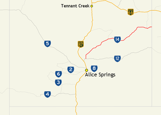
The Sandover Highway is an outback unsealed track in the Northern Territory between the Plenty Highway north of Alice Springs and the Northern Territory/Queensland border.

The Carpentaria Highway is a 380-kilometre-long (240 mi) highway, which runs from near Daly Waters to Borroloola in the Northern Territory, Australia. It is a sealed road and is part of National Highway 1. The Highway takes its name from the Gulf of Carpentaria, which it links with the Stuart Highway. The Carpentaria Highway also provides road access to the McArthur River mineral deposits and port facilities at Bing Bong, as well as the isolated community of Borroloola and the popular fishing location at King Ash Bay. Funding for maintenance is provided by the Northern Territory government.

The Tablelands Highway is a 375 kilometre single lane sealed road in the Northern Territory, Australia. It runs from Barkly Homestead on the Barkly Highway to Cape Crawford near Borroloola on the Carpentaria Highway.
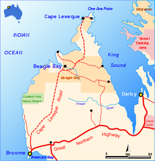
The Cape Leveque Road is a regional Western Australian road that runs through pindan woodland for 205 kilometres (127 mi) between Broome and Cape Leveque on the Dampier Peninsula.

Duncan Road is a generally northeast-southwest former highway in the northeast of Western Australia and northwest of Northern Territory that links the Victoria Highway with Halls Creek. The road, approximately 443 kilometres (275 mi) in length, was designated as National Route 80 from its terminus at Halls Creek through to Nicholson. National Route 80 continued east into the Northern Territory along Buntine Highway, while Duncan Road snakes its way north, crossing the state border numerous times between Buntine Highway and Victoria Highway.
Dorat Road is a designated state route in the Northern Territory of Australia providing an alternative route to the Stuart Highway from Adelaide River and rejoining north of Hayes Creek, a distance of 65 km (40 mi). The road provides access to tourist attractions including Robin Falls and Douglas-Daly Hot Springs, several World War II heritage locations, and forms part of the road access to Daly River and Wadeye via the Daly River Road which branches from Dorat Road approximately 31 km (19 mi) south of Adelaide River.
Delamere is a locality in the Northern Territory of Australia about 369 kilometres (229 mi) south of the territory capital of Darwin.
Northern Australia Roads Program is a suite of projects designed to deliver upgrades to high priority roads in northern Australia. In 2016 the Australian Government announced 19 projects to be funded under this program, and in 2020 another was added. This program is separate to the Northern Australia Beef Roads Program, also announced in 2016, which contains a further 18 projects.
