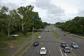
Casuarina is an electoral division of the Legislative Assembly in Australia's Northern Territory. It was first created in 1974 and was named after the adjacent suburb of Casuarina. Casuarina is an entirely urban electorate, covering only 12 km2 and taking in the suburbs of Brinkin, Nakara, Tiwi and part of Alawa, as well as the Charles Darwin University. There were 5,647 people enrolled in the electorate as of August 2020.

Wanneroo Road is a 44-kilometre (27 mi) arterial highway in the northern suburbs of Perth, Western Australia linking Joondanna and Yokine in the south with Wanneroo and Yanchep in the north. As part of State Route 60, it begins from Charles Street in the inner city and becomes Indian Ocean Drive up to Dongara.

Reid Highway is a 23-kilometre (14 mi) east-west highway and partial freeway in the northern suburbs of Perth, Western Australia, linking North Beach with Middle Swan. As part of State Route 3, it forms half of Perth's outer ring road along with Roe Highway, which it joins onto at its eastern terminus.
Tonkin Highway is an 81-kilometre-long (50 mi) north–south highway and partial freeway in Perth, Western Australia, linking Perth Airport and Kewdale with the city's north-eastern and south-eastern suburbs. As of April 2020, the northern terminus is at the interchange with Brand Highway and Great Northern Highway in Muchea, and the southern terminus is at Thomas Road in Oakford. It forms the entire length of State Route 4, and connects to several major roads. Besides Brand Highway and Great Northern Highway, it also connects to Reid Highway, Great Eastern Highway, Leach Highway, Roe Highway, and Albany Highway.

Marmion Avenue is a 40-kilometre (25 mi) arterial road in the northern coastal suburbs of Perth, Western Australia, linking Trigg in the south with Yanchep in the north. It forms part of State Route 71 along with West Coast Highway, which it joins onto at its southern terminus.

Beechboro Road is a north–south arterial road located in the northeastern suburbs of Perth, Western Australia, connecting Morley and Bayswater with areas further north. Until the construction of the nearby section of Tonkin Highway between 1984 and 1992, and later, during the NorthLink WA road project between 2016 and 2019, Beechboro Road was one of northeastern Perth's most important routes. The road is discontinuous at Tonkin Highway, with the section from Tonkin Highway to Walter Road officially known as Beechboro Road North, and the section running through Bayswater as Beechboro Road South.

Wagaman is a suburb of the Australian city of Darwin, Northern Territory. It lies in the band of locations known as the northern suburbs. It is on the traditional Country and waterways of the Larrakia people. An established residential area, Wagaman is bounded by Vanderlin Drive in the north, Lee Point Road in the east, Parer Drive in the south and Trower Road in the west; these confines correspond to the neighbouring suburbs of Alawa, Moil, Anula, Wanguri and Casuarina.
Shenton Avenue is an east–west distributor road in the northern suburbs of Perth, Western Australia, located within the City of Joondalup. The road primarily links Joondalup's coastal suburbs with the Joondalup central business district, which it passes through. It is also an entrance to the Mitchell Freeway.

Millner is a northern suburb in the city of Darwin, in the Northern Territory of Australia. It is the traditional country and waterways of the Larrakia people.
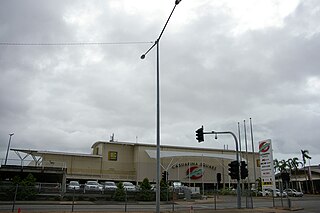
Casuarina Square, the largest shopping centre in the Northern Territory, is located in Casuarina in Darwin's northern suburbs. The shopping centre is built to the building code for Tropical Cyclones, due to cyclones that sweep through the area such as Cyclone Tracy in 1974.

Tiwi is a northern suburb of the city of Darwin, Northern Territory, Australia. The suburb is bounded by Trower Road, Henbury Avenue and a coastal strip, separating Casuarina Beach and Lee Point Beach. It is in the Local Government Area of City of Darwin. It is home to Dripstone Middle School.

Rapid Creek refers to both a creek in the city of Darwin, Northern Territory, Australia and the name of a suburb north of the city, situated where the creek meets Darwin Harbour. It is the traditional country and waterways of the Larrakia people.

Brinkin is a northern suburb of Darwin, the capital city of the Northern Territory, Australia. It is located 12 kilometres (7 mi) north of Darwin's central business district, and is home to the Casuarina campus of Charles Darwin University. It is the traditional country and waterways of the Larrakia people.

Nakara is a northern suburb of the city of Darwin, Northern Territory, Australia. The suburb is bounded by Trower Road, Ellengowen Drive and Dripstone Road. It is in the local government area of City of Darwin. The suburb is mostly residential. It is on the traditional Country and waterways of the Larrakia people.

Alawa is a northern suburb of the city of Darwin, Northern Territory, Australia. It is bounded by Trower and Dripstone Roads, Lakeside Drive and the Rapid Creek in the local government area of City of Darwin. It is the traditional country and waterways of the Larrakia people.

Coconut Grove is a northern suburb of the city of Darwin, Northern Territory, Australia within the local government area of City of Darwin. It is the traditional country and waterways of the Larrakia people.

Tiger Brennan Drive is a major arterial road in the western suburbs of Darwin, Northern Territory, Australia. The road travels southeast–east starting from Darwin CBD toward Darwin's eastern suburb of Berrimah, then continues to a connection with the Stuart Highway at Palmerston. Tiger Brennan Drive runs parallel with the Stuart Highway for most of its length. The road was named after Harold "Tiger" Brennan, a long serving Northern Territory politician and former mayor of Darwin. The road has been assigned the alphanumeric route designation A15 for its entire length.
Berrimah Road is a major arterial road in the outer eastern suburbs of Darwin, Northern Territory Australia. The road provides an important transport corridor to access the port facilities at East Arm as well as the northernmost passenger and freight terminals on the Adelaide-Darwin railway. It has undergone recent upgrades as part of the Tiger Brennan Drive extension works between 2009 and 2012. Berrimah Road is used by approximately 4000 vehicles per day, including a large proportion of heavy trucks and this number is expected to increase significantly with the growth of the port activities There are major junctions controlled by traffic lights at Tiger Brennan Drive and Wishart Road, as well as a public weighbridge used by trucks entering and exiting the industrial precinct at the southern end.

Bagot Road is a major arterial road in Darwin, Northern Territory Australia. The road forms part of the main transport route between the Central Business District, northern suburbs and Darwin International Airport. The origins of the name Bagot Road is believed to be in reference to the Bagot family of South Australia, who had significant land holdings in the early Northern Territory. In 2010, the road was used by an average of 34,487 vehicles per day. Due to the high traffic volumes, a number of major retailers and fast food outlets are situated along Bagot Road. Darwinbus Route 10 and Orbital Link services travel the length of Bagot Road with frequent stops in both directions.
Robertson Drive, also known as the Bunbury Bypass, Bunbury Ring Road, or Bunbury Inner Ring Road, is a 4.9-kilometre-long (3.0 mi) road in Bunbury, Western Australia. It forms a partial ring road around Bunbury, allowing highway traffic to bypass the city centre. The road connects four highway routes that radiate out Bunbury: Forrest Highway to the north, South Western Highway north-eastbound and south-east bound, and Bussell Highway to the south. A dual carriageway along the route was completed in 1992.