Rapid Creek, Northern Territory

Last updated

Rapid Creek
Darwin,  Northern Territory
Rapid Creek-nt.jpg
Darwin-Palmerston locator map.svg
Red pog.svg
Rapid Creek
Coordinates 12°22′51″S130°51′44″E / 12.38083°S 130.86222°E / -12.38083; 130.86222
Population3,261 (SAL 2021) [1]
Postcode(s) 0810
Area1.9 km2 (0.7 sq mi)
Location11 km (7 mi) from Darwin City
LGA(s) City of Darwin
Territory electorate(s) Nightcliff
Federal division(s) Solomon
Suburbs around Rapid Creek:
Darwin Harbour Darwin Harbour Brinkin
Nightcliff Rapid Creek Alawa
Coconut Grove Millner Jingili
FootnotesAdjoining suburbs [2] [3]
Rapid Creek at sunset taken from the footbridge Rapid Creek NT.jpg
Rapid Creek at sunset taken from the footbridge

Rapid Creek refers to both a creek in the city of Darwin, Northern Territory, Australia and the name of a suburb north of the city, situated where the creek meets Darwin Harbour. It is the traditional country and waterways of the Larrakia people. [4]

Contents

History

The creek is known to Larrakia People as Gurinbey, that means 'elbow', referring to the bend in its formation. [5]

Although the precise circumstances of the re-naming of Rapid Creek remain obscure, the name must have been applied by Surveyor-General George W. Goyder's surveyors not long after the arrival of the 1869 Northern Territory Survey Expedition. The outline of the creek, running from Marrara swamp to the sea between Casuarina Beach and Nightcliff, is present on Goyder's map, though no name appears on it. Goyder personally visited the locality on Saturday, 3 April 1869 and described the creek, without naming it, as "a strong shallow stream near Night Cliff". Sometime between then and 13 September, the name came into existence. There is an entry in Goyder's diary for the latter date which records that surveyor George MacLachlan was sent out to Rapid Creek to check on the availability of fresh water and good feed for the horses. On the basis of a satisfactory report from MacLachlan, "all the spare bullocks and horses were sent out to Rapid Creek to rest", two days later.

The name remained in common local usage and it is evident that settlers continued to visit the area regularly. In a book published in 1882, William Sowden described travelling from Palmerston (Darwin) to Casuarina Beach passing "Rapid Creek, which rushes swiftly along its bed during the wet season, but at other times during the dry.....its waters are clear and crystal". The year 1882 also saw the establishment of the first permanent settlement in the area.

The suburb of Rapid Creek is bounded by the Darwin Harbour foreshore in the north, the Rapid Creek in the east, Trower Road in the south and Nightcliff Road in the west. Rapid Creek was originally established in the late 19th century when it was settled by the German Jesuit Mission from 1882 to 1891, which proved unsuccessful. [6]

Rapid Creek prior to World War II was a favourite day trip / picnic area for Darwin residents, along the bush track which later became Bagot Road and McMillans Road. After Nightcliff grew as a seaside suburb in the 1950s, residential development expanded into the Rapid Creek area, primarily during the 1960s. The streets in Rapid Creek are mostly named after early police officers.

Nightcliff and Rapid Creek were the first Darwin suburbs to feel the force of Cyclone Tracy which came off the Timor Sea on 25 December 1974. Many of the residential buildings were totally destroyed.

Present day

Rapid Creek is a predominantly residential area and is generally associated with its sister suburb, Nightcliff, and the adjacent northern suburbs of Millner and Coconut Grove. A lot of development has been completed on the coastal road, Casuarina Drive, which runs along the coast from Rapid Creek to Nightcliff.[ citation needed ]

Rapid Creek Sunday Market is the oldest market in Darwin. [7] It's held every Sunday morning, and comprises stalls selling fresh produce including fruit, vegetables, Asian produce, herbs and spices, exotic plants, and seafood. There are also food stalls selling dishes from a variety of cuisines including Indian curries, Malaysian Laksa, Vietnamese rice paper rolls and Thai papaya salad. [8]

Related Research Articles

<span class="mw-page-title-main">Darwin, Northern Territory</span> Capital city of the Northern Territory, Australia

Darwin is the capital city of the Northern Territory, Australia. With a population of 139,902 at the 2021 census, the city contains most of the sparsely populated Northern Territory's residents. It is the smallest, wettest, and most northerly of the Australian capital cities and serves as the Top End's regional centre.

<span class="mw-page-title-main">Nightcliff, Northern Territory</span> Suburb of Darwin, the Northern Territory, Australia

Nightcliff is a northern suburb of the city of Darwin, Northern Territory, Australia. It is the traditional country and waterways of the Larrakia people.

<span class="mw-page-title-main">George Goyder</span> 19th century surveyor in South Australia

George Woodroffe Goyder was a surveyor in the Colony of South Australia during the latter half of the nineteenth century.

Casuarina is one of the northern suburbs of Darwin, the capital of the Northern Territory of Australia. It is the traditional country and waterways of the Larrakia people.

<span class="mw-page-title-main">Millner, Northern Territory</span> Suburb of Darwin, the Northern Territory, Australia

Millner is a northern suburb in the city of Darwin, in the Northern Territory of Australia. It is the traditional country and waterways of the Larrakia people.

<span class="mw-page-title-main">Fannie Bay, Northern Territory</span> Suburb of Darwin, the Northern Territory, Australia

Fannie Bay is a middle/inner suburb of the city of Darwin, Northern Territory, Australia. It is the traditional country and waterways of the Larrakia people.

<span class="mw-page-title-main">Tiwi, Northern Territory</span> Suburb of Darwin, the Northern Territory, Australia

Tiwi is a northern suburb of the city of Darwin, Northern Territory, Australia. The suburb is bounded by Trower Road, Henbury Avenue and a coastal strip, separating Casuarina Beach and Lee Point Beach. It is in the Local Government Area of City of Darwin. It is home to Dripstone Middle School.

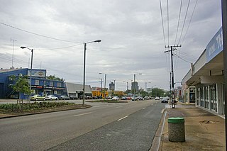
Nightcliff Middle School is a coeducational state school situated between Nightcliff Road, Aralia Street and Ryland Road, in the northern Darwin suburb of Rapid Creek, Northern Territory, Australia.

<span class="mw-page-title-main">Brinkin, Northern Territory</span> Suburb of Darwin, the Northern Territory, Australia

Brinkin is a northern suburb of Darwin, the capital city of the Northern Territory, Australia. It is located 12 kilometres (7 mi) north of Darwin's central business district, and is home to the Casuarina campus of Charles Darwin University. It is the traditional country and waterways of the Larrakia people.

<span class="mw-page-title-main">Alawa, Northern Territory</span> Suburb of Darwin, the Northern Territory, Australia

Alawa is a northern suburb of the city of Darwin, Northern Territory, Australia. It is bounded by Trower and Dripstone Roads, Lakeside Drive and the Rapid Creek in the local government area of City of Darwin. It is the traditional country and waterways of the Larrakia people.

<span class="mw-page-title-main">Coconut Grove, Northern Territory</span> Suburb of Darwin, the Northern Territory, Australia

Coconut Grove is a northern suburb of the city of Darwin, Northern Territory, Australia within the local government area of City of Darwin. It is the traditional country and waterways of the Larrakia people.

<span class="mw-page-title-main">Ludmilla, Northern Territory</span> Suburb of Darwin, the Northern Territory, Australia

Ludmilla is a northern inner suburb of the city of Darwin, Northern Territory, Australia. It is the traditional country and waterways of the Larrakia people.

<span class="mw-page-title-main">Jingili, Northern Territory</span> Suburb of Darwin, the Northern Territory, Australia

Jingili is a northern suburb of the city of Darwin, Northern Territory, Australia. It is the traditional country and waterways of the Larrakia people.

<span class="mw-page-title-main">Lee Point, Northern Territory</span> Suburb of Darwin, the Northern Territory, Australia

Lee Point refers to a coastal point north of the city of Darwin, Northern Territory, Australia. It is on the traditional Country and waterways of the Larrakia people.

<span class="mw-page-title-main">Stuart Park, Northern Territory</span> Suburb of Darwin, the Northern Territory, Australia

Stuart Park is an inner suburb of the city of Darwin, Northern Territory, Australia. It is the traditional country and waterways of the Larrakia people.

<span class="mw-page-title-main">Leanyer, Northern Territory</span> Suburb of Darwin, the Northern Territory, Australia

Leanyer is a northern suburb of Darwin, in the Northern Territory of Australia. It is on the traditional Country and waterways of the Larrakia people.

<span class="mw-page-title-main">Knuckey Lagoon, Northern Territory</span> Suburb of Darwin, the Northern Territory, Australia

Knuckey Lagoon is an outer suburban area in Darwin. It is 18 kilometres (11 mi) east of the Darwin CBD. Its Local Government Area is the Litchfield Municipality. The suburb is mostly a rural area, on the fringe of Metropolitan Darwin. The area was named by Surveyor General G W Goyder after his Senior Surveyor, Richard Randall Knuckey.

Bees Creek is an outer rural area of Darwin, Northern Territory, Australia. It is 33 km southeast of the Darwin central business district. It is the council seat of the local government area of the Litchfield Municipality, although most council facilities, public amenities and the actual Municipal offices are in the neighbouring locality of Freds Pass. Bees Creek is mostly rural, with large residential blocks often not served by town sewers or sealed roads. Nevertheless, the area is popular with those wishing to enjoy a rural lifestyle within an easy commuting distance of the city.

<span class="mw-page-title-main">Darwin central business district</span> Suburb of Darwin, the Northern Territory, Australia

Darwin City is a suburb in metropolitan Darwin which comprises the original settlement, the central business district, parkland and other built-up areas. It is the traditional country and waterways of the Larrakia people. It is original site of occupation and includes many of the city's important institutions and landmarks, such as Parliament, Government House, the Northern Territory Supreme Court, Bicentennial Park and the George Brown Darwin Botanic Gardens. The city centre is located in the local government areas of the City of Darwin and the Darwin Waterfront Precinct.

<span class="mw-page-title-main">Charles Darwin, Northern Territory</span> Suburb of Darwin, the Northern Territory, Australia

Charles Darwin is an eastern suburb in the city of Darwin, in the Northern Territory of Australia. It is the traditional country and waterways of the Larrakia people.

References

  1. Australian Bureau of Statistics (28 June 2022). "Rapid Creek (suburb and locality)". Australian Census 2021 QuickStats. Retrieved 28 June 2022.  OOjs UI icon edit-ltr-progressive.svg
  2. "Rapid Creek". NT Atlas and Spatial Data Directory. Northern Territory Government. Retrieved 30 April 2019.
  3. "Darwin City Council Suburbs" (PDF). Place Names Committee. Northern Territory Government. Retrieved 30 April 2019.
  4. "The Larrakia People". Larrakia Nation. 31 March 2023. Retrieved 1 December 2023.
  5. Stringfellow, Rachel (23 May 2023). "Darwin Elder Richard Fejo's life of advocacy honoured by Flinders University". National Indigenous Times. Retrieved 15 December 2023.
  6. Rapid Creek (1882-1891), German Missionaries in Australia.
  7. "Rapid Creek Sunday Markets | Rapid Creek Shopping Centre". www.rapidcreekshoppingcentre.com.au. Retrieved 26 June 2016.
  8. Planet, Lonely. "Rapid Creek Market - Lonely Planet". Lonely Planet. Retrieved 26 June 2016.