Palmerston is a planned satellite city of Darwin, the capital and largest city of Australia's Northern Territory. The city is situated approximately 20 kilometres from Darwin and 10 kilometres from Howard Springs and the surrounding rural areas. Palmerston had a population of 33,695 at the 2016 census, making it the second largest city in the Northern Territory.
The City of Hobsons Bay is a local government area in Melbourne, Victoria, Australia. It comprises the south-western suburbs between 6 and 20 km from the Melbourne city centre.
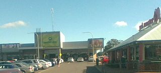
Hampton Park is a suburb in Melbourne, Victoria, Australia, 36 km south-east of Melbourne's Central Business District, located within the City of Casey local government area. Hampton Park recorded a population of 26,082 at the 2021 census.

North Beach is a northern coastal suburb of Perth, the capital city of Western Australia 16 kilometres (10 mi) from Perth's central business district via Mitchell Freeway and Reid Highway. Its local government area is the City of Stirling.

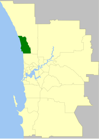
The City of Wanneroo is a local government area with city status in the northern suburbs of Perth, Western Australia. It is centred approximately 25 kilometres (15.5 mi) north of Perth's central business district and forms part of the northern boundary of the Perth metropolitan area. Wangara encompasses the federal divisions of Cowan, Moore and Pearce.
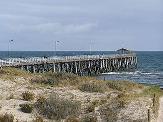
Grange is a coastal suburb of the City of Charles Sturt, in Adelaide, South Australia, located about 11 kilometres (6.8 mi) from the Adelaide city centre. The suburb is named after Captain Charles Sturt's cottage, built in 1840–41, which still stands and is now a museum. In addition to Grange Beach, the suburb has several parks and reserves, as well as the Grange Hotel, which was originally licensed in 1881.

Warriewood is a suburb in northern Sydney, in the state of New South Wales, Australia. Warriewood is located 26 kilometres north of the Sydney central business district, in the local government area of Northern Beaches Council. Warriewood is part of the Northern Beaches region.

Ridgewood is an outer suburb of Perth, Western Australia, located 37 kilometres north of Perth's central business district. It is part of the City of Wanneroo local government area.

Denham Court is a suburb of Sydney, in the state of New South Wales, Australia located 44 kilometres (27 mi) south-west of the Sydney central business district, in the local government areas of the City of Campbelltown, City of Liverpool and City of Camden. It is part of the Macarthur region.
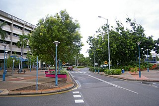
Casuarina is one of the northern suburbs of Darwin, the capital of the Northern Territory of Australia. It is the traditional country and waterways of the Larrakia people.
The City of Joondalup is a local government area in Perth, Western Australia. Its central business district is located in the suburb Joondalup, and it includes the town centres of Hillarys and Warwick.

The City of Darwin is a local government area of the Northern Territory, Australia. It includes the central business district of the capital, Darwin City, and represents two-thirds of its metropolitan population. Located on the traditional land and waterways of the Larrakia people, the city now covers an area of 111 square kilometres (43 sq mi) and, in June 2018, had a population of 84,613 people.

Tiwi is a northern suburb of the city of Darwin, Northern Territory, Australia. The suburb is bounded by Trower Road, Henbury Avenue and a coastal strip, separating Casuarina Beach and Lee Point Beach. It is in the Local Government Area of City of Darwin. It is home to Dripstone Middle School.

Rapid Creek is both a creek in the city of Darwin, Northern Territory, Australia and the name of a suburb north of the city, situated where the creek empties into Darwin Harbour. It is the traditional country and waterways of the Larrakia people.

Alawa is a northern suburb of the city of Darwin, Northern Territory, Australia. It is bounded by Trower and Dripstone Roads, Lakeside Drive and the Rapid Creek in the local government area of City of Darwin. It is the traditional country and waterways of the Larrakia people.

Berrimah is an eastern suburb in the city of Darwin, in the Northern Territory of Australia. Berrimah is on the traditional country and waterways of the Larrakia people.

Coconut Grove is a northern suburb of the city of Darwin, Northern Territory, Australia within the local government area of City of Darwin. It is the traditional country and waterways of the Larrakia people.

Wulagi is a Northern suburb of Darwin, Northern Territory, in the Northern Territory of Australia.

Knuckey Lagoon is an outer suburban area in Darwin. It is 18 kilometres (11 mi) east of the Darwin CBD. Its Local Government Area is the Litchfield Municipality. The suburb is mostly a rural area, on the fringe of Metropolitan Darwin. The area was named by Surveyor General G W Goyder after his Senior Surveyor, Richard Randall Knuckey.
Trower Road is a major arterial road in the northern suburbs of Darwin, Northern Territory, Australia. The road is a major access route for services and institutions located in the Casuarina area, including Casuarina Square, Royal Darwin Hospital and Charles Darwin University. The road is named for Horace M Trower, Director of Lands from 1917-21. It is one of the busiest roads in Darwin, used by an average of 27,084 vehicles per day in 2010, behind only Bagot Road and the Stuart Highway. Trower Road provides dual carriageways separated by central median for most of its length, however as many suburban collector roads meet along the route, the maximum speed limit is 70 km/h (43 mph). The road was opened in stages between 1963 and 1969 as development in the northern suburbs progressed. A final extension in 1981 providing access to the Casuarina Coastal Reserve left a section of the road in Brinkin isolated from the main route.

