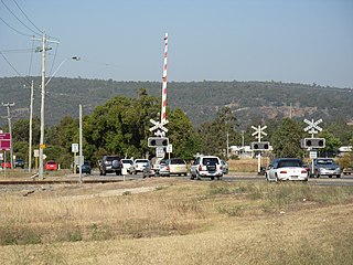
A network of main roads connects towns within the Wheatbelt to each other, the highways, and neighbouring regions, with local roads providing additional links and access to smaller townsites. Roads are often named after the towns they connect.[5][6][7]
Albany Highway is a main north-west to south-east highway in the southern Wheatbelt, close to or just outside the region's western edge. It passes through the towns of North Bannister, Crossman, Williams, and Arthur River.[6]
Bindoon Moora Road[3] (also referred to as Bindoon–Moora Road[7] or Moora Bindoon Road[5]) is a major north-south road from Bindoon to Moora, in the northern Wheatbelt. The southern terminus is at Great Northern Highway north of the Bindoon townsite, and the northern terminus is at the outskirts of Moora, with the route continuing into the town centre as Padbury Street.[5][7] It is the southern section of State Route 116, which continues north-west to Dongara.[9]
Brand Highway is a main north-west to south-east highway in the northern Wheatbelt, parallel to the coast. From Muchea, it travels in a north-westerly direction, passing to the west of Gingin, and through Cataby and Badgingarra. Shortly after the turnoff to Jurien Bay, it leaves the Wheatbelt region.[5]
Main Roads Western Australia identifies the section west of Collie as H45 Coalfields Highway, and the rest as part of M37 Collie–Lake King Road.[7][11]
Collie Williams Road is a major road near the south-western edge of the Wheatbelt. Starting at the Pinjarra Williams Road, west of the Williams townsite, the road heads in a south-westerly direction towards Collie, in the state's South West region.[6]
Corrigin Kulin Road is a major north-south road in the Wheatbelt. It is the southern section of the route between Corrigin and Kulin. The northern terminus is in Gorge Rock, at Corrigin Kondinin Road, which continues north-west to Corrigin.[6]
Dumbleyung Lake Grace Road is a major east-west road linking Dumbleyung and Lake Grace, near the southern edge of the Wheatbelt. The road passes to the north of Kukerin near the halfway point.[6] It is part of State Route 107, which continues west to Bunbury and east to Lake King.[9]
Goomalling Toodyay Road is a major east-west road in the northern Wheatbelt. It travels from Goomalling to Wyalkatchem via Dowerin, and was previously known as Goomalling Merredin Road.[5]
Great Eastern Highway is the main east-west highway through the centre of the Wheatbelt. From the eastern edge of Perth just past The Lakes, it heads east, bypassing Northam, and continuing through Merredin and Southern Cross towards the goldfields.[5]
Great Northern Highway is a main highway in the northern Wheatbelt, and part of the Perth to Darwin national highway. From the north-eastern edge of Perth, the highway travels north through Muchea, Bindoon, and New Norcia. It then heads generally north-easterly, to Dalwallinu, Wubin, and into the Midwest region beyond.[5]
Great Southern Highway is a major north-south road in the southern Wheatbelt. From The Lakes at the eastern edge of Perth, the highway travels east to York, along a road previously known as Chidlow York Road. It then heads south through Beverley, Brookton, Narrogin, and Wagin.[5][6]
Jurien Road, also known as Jurien East Road,[8] is a major east-west road near the northern edge of the Wheatbelt, linking the coastal town of Jurien Bay with the Brand Highway at Hill River.[5]
Merredin–Nungarin Road,[3] also known as Merredin Nungarin Road[8] or Nungarin Merredin Road,[5] is a major north-south road in the eastern Wheatbelt. It travels from Merredin to Nungarin, and was previously known as Goomalling Merredin Road.[5]
Midlands Road,[3] also known as The Midlands Road,[5] is a major road in the northern Wheatbelt. From Great Northern Highway at Walebing, the road travels west to Moora and then north to Watheroo. Beyond Watheroo, it continues north into the state's Mid West region. The section from Moora northwards is part of State Route 116, which continues south to Bindoon and north-west to Dongara.[9]
Newdegate Ravensthorpe Road is a major road near the southern edge of the Wheatbelt.[6] From Newdegate, it travels east to Lake King, and then south towards Ravensthorpe, in the state's Great Southern region. The east-west section is part of State Route 107, which continues west to Bunbury, while the north-south section is part of State Route 40, which links south-eastern Perth to Ravensthorpe.[9]
Northam York Road, also known as Northam–York Road, is a major north-south road in the central Wheatbelt, linking Northam and York, with the southern half of the route running alongside the Avon River.[5] It is part of State Route 120, which continues north to Toodyay and south to Cranbrook.[9]
Nungarin–Wyalkatchem Road,[3] also known as Nungarin Wyalkatchem Road[8] or Wyalkatchem Nungarin Road,[5] is a major east-west road in the northern Wheatbelt. It travels from Nungarin to Wyalkatchem via Kununoppin and Trayning. It was previously known as Goomalling Merredin Road.[5]
Peel Terrace is a major road within Northam, Western Australia. It starts as the continuation of Forrest Road at the Avon River. It crosses the river near the Northam Weir, and travels in an east-south-easterly direction. The first major intersection is with Fitzgerald Street and Taylor Street, which is controlled by traffic lights. It continues in a straight line, alongside the railway line, until it intersect Yilgarn Avenue and York Road. Yilgarn Avenue leads to Great Eastern Highway, while York Road continues south to Northam York Road.[5][13]
South-east of Fitzgerald Street, the road is part of State Route120, which links Toodyay in the north with Cranbrook in the south. The route continues through Northam along Fitzgerald Street and Newcastle Road northbound, towards Northam–Toodyay_Road, and along York Road to Northam York Road.[9]:29
Main Roads Western Australia controls the section south-east of Fitzgerald Street,[8] which was part Great Eastern Highway's former route, prior to the construction of the Northam bypass. The highway formerly continued east along Yilgarn Avenue, and west along Fitzgerald Street, Newcastle Road, and Mitchell Avenue.[14]
Pingrup Lake Grace Road is a major road near the southern edge of the Wheatbelt. Starting at the Lake Grace, the road heads south towards Pingrup, in the state's Great Southern region.[6]
Pinjarra Williams Road is a major road near the south-western edge of the Wheatbelt. Starting from Albany Highway at Williams, the road heads west to Quindanning, and then continues in a north-westerly direction into the state's Peel region, towards Pinjarra.[6]
Quairading–York Road,[3] also known as Quairading York Road,[5][6] is a major east-west road in the central Wheatbelt. It travels between Quairading and York, via Mawson.[5][6]
Southern Cross–Marvel Loch Road,[3] also known as Southern Cross Marvel Loch Road,[5] is a major road in the eastern Wheatbelt. From Great Eastern Highway at Southern Cross, it travels in a south-easterly direction to Marvel Loch.[5]
Toodyay Road is a major road from Perth into the northern Wheatbelt. From Morangup, just outside Perth's north-eastern edge, the road travels in a north-easterly direction to Toodyay. It is allocated State Route50.[9]
Wagin Dumbleyung Road is a major east-west road linking Wagin and Dumbleyung, near the southern edge of the Wheatbelt.[6] It is part of State Route107, which continues west to Bunbury and east to Lake King.[9]
Williams Kondinin Road is a major road between the Wheatbelt towns of Williams and Kondinin. From Williams, the road travels north-east to Narrogin and Wickepin, then east to Jitarning. It continues north-east to Kondinin, via Kulin.[6]
Toodyay, known as Newcastle between 1860 and 1910, is a town on the Avon River in the Wheatbelt region of Western Australia, 85 kilometres (53 mi) north-east of Perth. The first European settlement occurred in the area in 1836. After flooding in the 1850s, the townsite was moved to its current location in the 1860s. It is connected by railway and road to Perth. During the 1860s, it was home to bushranger Moondyne Joe.
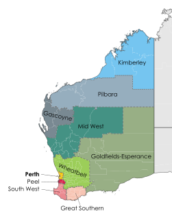
The Wheatbelt is one of nine regions of Western Australia defined as administrative areas for the state's regional development, and a vernacular term for the area converted to agriculture during colonisation. It partially surrounds the Perth metropolitan area, extending north from Perth to the Mid West region, and east to the Goldfields-Esperance region. It is bordered to the south by the South West and Great Southern regions, and to the west by the Indian Ocean, the Perth metropolitan area, and the Peel region. Altogether, it has an area of 154,862 square kilometres (59,793 sq mi).
Great Northern Highway is an Australian highway that links Western Australia's capital city Perth with its northernmost port, Wyndham. With a length of almost 3,200 kilometres (2,000 mi), it is the longest highway in Australia, with the majority included as part of the Perth Darwin National Highway. The highway is constructed as a sealed, predominantly two-lane single carriageway, but with some single-lane bridges in the Kimberley. The Great Northern Highway travels through remote areas of the state, and is the only sealed road link between the Northern Territory and northern Western Australia. Economically, it provides vital access through the Wheatbelt and Mid West to the resource-rich regions of the Pilbara and Kimberley. In these areas, the key industries of mining, agriculture and pastoral stations, and tourism are all dependent on the highway.
Great Eastern Highway is a 590-kilometre-long (370 mi) road that links the Western Australian capital of Perth with the city of Kalgoorlie. A key route for road vehicles accessing the eastern Wheatbelt and the Goldfields, it is the western portion of the main road link between Perth and the eastern states of Australia. The highway forms the majority of National Highway 94, although the alignment through the Perth suburbs of Guildford and Midland, and the eastern section between Coolgardie and Kalgoorlie are not included. Various segments form parts of other road routes, including National Route 1, Alternative National Route 94, and State Route 51.
The Division of O'Connor is an Australian electoral division in the state of Western Australia. It is one of Western Australia's three rural seats, and one of the largest electoral constituencies in the world.
Corrigin is a town in the central Wheatbelt region of Western Australia, 229 kilometres (142 mi) east-southeast of the state capital, Perth, Western Australia, along State Route 40. It is mostly a farming community focused on crops and sheep, and holds the world record of "the most dogs in a ute".
Brookton Highway is a 112 kilometres (70 mi) long undivided single carriageway highway in Western Australia, running from the southern Perth suburb of Kelmscott, through Westdale, to the southern Wheatbelt town of Brookton. It is signposted as State Route 40; however, the route and highway continue on far past Brookton, passing through Corrigin, Kondinin, Hyden, Lake King, and finishing at South Coast Highway, just west of Ravensthorpe.
Toodyay Road is a mostly 2-lane undivided single carriageway in Western Australia, running from the north-eastern Perth suburb of Middle Swan, through Gidgegannup and Bailup, to the Wheatbelt town of Toodyay. It is signposted as State Route 50.
Trayning is a town in the north-eastern Wheatbelt region of Western Australia, 236 kilometres (147 mi) east of the state capital, Perth, on the Nungarin–Wyalkatchem Road. At the 2006 census, Trayning had a population of 122.
Transport in Perth, Western Australia, is served by various means, among them an extensive highway / freeway network and a substantial system of commuter rail lines and bus routes. Public transport is managed by the Transperth agency.
Clackline is a locality in the Wheatbelt region of Western Australia, about 80 kilometres (50 mi) east-north-east of Perth.
The Eastern Districts Football League is an Australian rules football leagues based in the eastern Wheatbelt region of Western Australia. The league stretches from Southern Cross in the east, Hyden in the south, Corrigin in the west and Nukarni in the north.
The wheatbelt railway lines of Western Australia were, in most cases, a network of railway lines in Western Australia that primarily served the Wheatbelt region.
Western Australian Government Railways railway system during its peak operational time in the 1930s to 1950s was a large system of over 6,400 kilometres (4,000 mi) of railway line.
Tourist Drives in Western Australia are routes through areas of scenic or historic significance, designated by route markers with white numbers on a brown shield. Tourist Drives were introduced into Western Australia while Eric Charlton was the state government Minister for Transport in the 1990s. The 28 numbered routes collectively traverse more than 2,000 kilometres (1,200 mi) across the state. In addition to the Tourist Drives, there are unnumbered routes such as the Golden Pipeline Heritage Trail, and local governments may designate and maintain local scenic drives, generally unnamed and unnumbered.
Main Roads Western Australia controls the major roads in the state's Mid West region. There are four main highways through the Mid West: The north-south coastal route of Brand Highway and North West Coastal Highway, the inland alternative Great Northern Highway, and the northern section of Goldfields Highway, which links Meekatharra with Kalgoorlie. A network of main roads connects towns within the Mid West to each other, the highways, and neighbouring regions, with local roads providing additional links and access to smaller townsites. Roads are often named after the towns they connect.
Northam railway station is located in Northam on the Eastern Railway route in Western Australia. It is the second and more recent railway station in Northam.
This is a list of newspapers published in, or for, the Wheatbelt region of Western Australia.
References
↑ Main Roads Western Australia (2013). "Wheatbelt North Regional Profile"(PDF). Government of Western Australia. p.2. Archived from the original(PDF) on 26 December 2013. Retrieved 26 December 2013.
↑ Main Roads Western Australia (2013). "Wheatbelt South Regional Profile"(PDF). Government of Western Australia. p.2. Archived(PDF) from the original on 26 December 2013. Retrieved 26 December 2013.
↑ Main Roads Western Australia (16 December 2013). "Our Role in the Regions". Government of Western Australia. Archived from the original on 21 October 2013. Retrieved 26 December 2013.
1 2 3 4 5 6 7 8 9 10 11 12 Main Roads Western Australia (28 February 2011). "Wheatbelt Network" (Map). Intergrated Service Arrangement. 1:2,040,816. Government of Western Australia. Archived from the original(PDF) on 3 August 2013. Retrieved 20 December 2013.
↑ South West Region map(PDF) (PDF). Version 1.0. Cartography by Main Roads Western Australia. Main Roads Western Australia. 13 August 2013. Archived from the original(PDF) on 28 September 2013. Retrieved 25 December 2013.
↑ "South West and Great Southern Network"(PDF). Integrated Service Arrangement. Main Roads Western Australia. 28 February 2011. Archived(PDF) from the original on 27 December 2013. Retrieved 25 December 2013.
↑ Proposed bypass of Great Eastern Highway at Northam: Main Roads Department of Western Australia: Report and recommendations of the Environmental Protection Authority. Perth, Western Australia: Environmental Protection Authority. November 1993. pp.i, 1–3. ISBN0-7309-5646-6.
This page is based on this Wikipedia article Text is available under the CC BY-SA 4.0 license; additional terms may apply. Images, videos and audio are available under their respective licenses.