
Hamersley is a residential suburb 14 kilometres north-northwest of the central business district of Perth, the capital of Western Australia, and six kilometres (4 mi) from the Indian Ocean. The suburb adjoins two major arterial roads—Mitchell Freeway to the west and Reid Highway to the south—and is within the City of Stirling local government area. It was built during the late 1960s and 1970s as part of the Government of Western Australia's response to rapidly increasing land prices across the metropolitan area.

Toodyay, known as Newcastle between 1860 and 1910, is a town on the Avon River in the Wheatbelt region of Western Australia, 85 kilometres (53 mi) north-east of Perth. The first European settlement occurred in the area in 1836. After flooding in the 1850s, the townsite was moved to its current location in the 1860s. It is connected by railway and road to Perth. During the 1860s, it was home to bushranger Moondyne Joe.

Peppermint Grove is an affluent western suburb of Perth, Western Australia on the north bank of the Swan River at Freshwater Bay. Its local government area, the smallest in the country, is the Shire of Peppermint Grove. The suburb was named after its trademark Swan River peppermint trees lining many streets. The suburb has long been associated with Western Australia's wealthiest and oldest families. Their prosperity is reflected in the many historical houses in the area, such as The Cliffe and the Federation Queen Anne style St Just. Colin Barnett, a former Premier of Western Australia, dubbed the suburb "Monaco of WA" due to its small size and concentration of wealth.

Mundaring is a suburb located 34 km east of Perth, Western Australia on the Great Eastern Highway. The suburb is located within the Shire of Mundaring.

Wagin is a town and shire in the Wheatbelt region of Western Australia, approximately 225 km (139.81 mi) south-east of Perth on the Great Southern Highway between Narrogin and Katanning. It is also on State Route 107. The main industries are wheat and sheep farming.

Bolgart is a townsite north of Toodyay in Western Australia. It is in the Shire of Victoria Plains.

Boyup Brook is a town in the south-west of Western Australia, 269 kilometres (167 mi) south-southeast of Perth and 31 kilometres (19 mi) northeast of Bridgetown. The town lies on Kaniyang land within the Noongar nation.
Yerecoin is a small town located in the Wheatbelt region of Western Australia, in the Shire of Victoria Plains,156 kilometres (97 mi) north-northeast of the state capital, Perth.
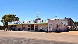
Cadoux is a town in the northeastern Wheatbelt region of Western Australia. It is about 180 kilometres (112 mi) northeast of Perth, within the Shire of Wongan-Ballidu.

Meckering is a town 130 kilometres (80.8 mi) east of Perth, Western Australia along the Great Eastern Highway. Meckering is located within the Shire of Cunderdin.
Lake Muir is a freshwater lake, with a larger surrounding wetlands area, that is located in the South West region of Western Australia. The lake lies near Muirs Highway, north of Walpole and southeast of Manjimup.

Frederica Lucy "Rica" Erickson, née Sandilands, was an Australian naturalist, botanical artist, historian, author and teacher. Without any formal scientific training, she wrote extensively on botany and birds, as well as genealogy and general history. Erickson authored ten books, co-authored four, was editor of twelve, and author or co-author of numerous papers and articles that have been printed in popular, scientific and encyclopaedic publications.

The Shire of Victoria Plains is a local government area in the Wheatbelt region of Western Australia, about 160 kilometres (100 mi) north of the state capital, Perth. It covers an area of 2,569 square kilometres (992 sq mi), and its seat of government is the town of Calingiri.

Beacon is a town in Western Australia, in the Shire of Mount Marshall. It is 42 km (26 mi) north of Bencubbin and 333 km (207 mi) northeast of Perth by road.

The Shire of Cunderdin is a local government area in the Wheatbelt region of Western Australia, about 105 kilometres (65 mi) west of Merredin and about 155 kilometres (96 mi) east of Perth, the state capital. The Shire covers an area of 1,864 square kilometres (720 sq mi), and its seat of government is the town of Cunderdin.

Quairading is a Western Australian town located in the Wheatbelt region. It is the seat of government for the Shire of Quairading.
Earthquakes have occurred in Western Australia (WA) on a regular basis throughout its geological history.
The South West Seismic Zone is a major intraplate earthquake province located in the south west of Western Australia. It was known earlier as the Yandanooka – Cape Riche Lineament, corresponds to the physiographic boundary known as the Meckering Line, and also the junction between Swanland and Salinaland.
The zone exists within an Archaean Shield structure called the Yilgarn Block. The identified geological subdivisions within this Precambrian structure do not show an obvious relation to the seismicity.

The town of Toodyay, Western Australia, was not always known by that name. Initially Toodyay was located in what is now West Toodyay before repeated flooding caused the town centre to migrate to the area around the Newcastle convict depot creating the town of Newcastle. After approximately 50 years of confusion the name of Newcastle was changed to Toodyay and the original Toodyay became known as West Toodyay.
The Western Australian town of Meckering was struck by an earthquake on 14 October 1968. The earthquake occurred at , with a moment magnitude of 6.5 and a maximum Mercalli intensity of IX (Violent). Total damage amounted to $2.2 million with 20–28 injured.


