Meckering, Western Australia

Last updated • 1 min readFrom Wikipedia, The Free Encyclopedia

Meckering
Western Australia
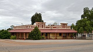
Meckering Hall, Meckering, Western Australia.jpg
Meckering Hall
Australia Western Australia location map.svg
Red pog.svg
Meckering
Meckering, Western Australia
Coordinates 31°38′S117°00′E / 31.633°S 117.000°E / -31.633; 117.000
Population232 (SAL 2021) [1]
Established1895
Postcode(s) 6405
Elevation203 m (666 ft)
Area216 km2 (83 sq mi)
Location
LGA(s) Shire of Cunderdin
State electorate(s) Central Wheatbelt
Federal division(s) Durack

Meckering is a town 130 kilometres (80.8 mi) east of Perth, Western Australia along the Great Eastern Highway. Meckering is located within the Shire of Cunderdin.

Contents

A railway line was completed in the area in 1895 and Meckering was selected as a station site. The first name chosen for the townsite was Beebering, the Aboriginal name for the hills just north of the town.

The townsite of Beebering was gazetted in 1895. The name of the town was changed to Meckering in 1897 to agree with the station name and the name for the town that was used locally. Meckering is an Aboriginal word thought to mean "moon on the water" or "good hunting". [2]

In early 1898 the population of the town was 225, 150 males and 75 females. [3]

In 1932 the Wheat Pool of Western Australia announced that the town would have two grain elevators, each fitted with an engine, installed at the railway siding. [4]

The surrounding areas produce wheat and other cereal crops. The town is a receival site for Cooperative Bulk Handling. [5]

Earthquake

The town was struck by an earthquake on Monday 14 October 1968. [6]

The earthquake occurred at 10:58:52 local time, with a moment magnitude of 6.5 and a maximum Mercalli intensity of IX (Violent). Total damage amounted to $2.2 million with 20–28 injured.[ according to whom? ]

Transport

Road freight

Meckering is a main stopping point for freight trucks on the way to the eastern states.

Passenger rail service

The MerredinLink service runs between East Perth and Merredin thrice weekly, terminating at Meckering. [7] The Prospector service between East Perth and Kalgoorlie stops at Meckering most days. [8]

See also

Related Research Articles

Transwa is Western Australia's regional public transport provider, linking 240 destinations, from Kalbarri in the north to Augusta in the south west to Esperance in the south east.

<span class="mw-page-title-main">Wheatbelt (Western Australia)</span> Region of Western Australia

The Wheatbelt is one of nine regions of Western Australia defined as administrative areas for the state's regional development, and a vernacular term for the area converted to agriculture during colonisation. It partially surrounds the Perth metropolitan area, extending north from Perth to the Mid West region, and east to the Goldfields–Esperance region. It is bordered to the south by the South West and Great Southern regions, and to the west by the Indian Ocean, the Perth metropolitan area, and the Peel region. Altogether, it has an area of 154,862 square kilometres (59,793 sq mi).

<span class="mw-page-title-main">Cunderdin, Western Australia</span> Town in the Wheatbelt region of Western Australia

Cunderdin is a town located in the Wheatbelt region of Western Australia 156 km east of Perth, along the Great Eastern Highway. Due to it being on the route of the Goldfields Water Supply Scheme it is also on the Golden Pipeline Heritage Trail. It is a rural community consisting of a district high school and an agricultural college.

<i>The Prospector</i> (train) Passenger train between East Perth and Kalgoorlie, Western Australia

The Prospector is a rural passenger train service in Western Australia operated by Transwa between East Perth and Kalgoorlie. On this service, two trains depart almost at the same time in opposite directions. One travels between East Perth and Kalgoorlie, the other between Kalgoorlie and East Perth with crew changeover occurring in Merredin. The original vehicles ordered in 1968 for trains providing this service were replaced in 2004 with vehicles capable of reducing journey times to 6 hours 45 minutes.

<span class="mw-page-title-main">Tammin, Western Australia</span> Town in Western Australia

Tammin is a town in the central agricultural region of Western Australia, 184 kilometres (114 mi) east of Perth and midway between the towns of Cunderdin and Kellerberrin on the Great Eastern Highway.

<span class="mw-page-title-main">Kellerberrin, Western Australia</span> Town in Western Australia

Kellerberrin is a town in the Wheatbelt region of Western Australia, 205 kilometres (127 mi) east of Perth on the Great Eastern Highway. The town serves as a stop on the Prospector and MerredinLink rural train services. It is also located on the Golden Pipeline Heritage Trail.

<span class="mw-page-title-main">Burracoppin, Western Australia</span> Town in Western Australia

Burracoppin is a townsite on the Great Eastern Highway, east of Merredin in the Wheatbelt region of Western Australia.

Carrabin is a small town located about 43 kilometres (27 mi) east-north-east of Merredin, on the railway line between Merredin and Southern Cross in Western Australia.

<span class="mw-page-title-main">Bodallin, Western Australia</span> Town in the Wheatbelt region of Western Australia

Bodallin is a town located around halfway between Merredin and Southern Cross in Western Australia.
<span class="mw-page-title-main">Moorine Rock, Western Australia</span> Town in Western Australia

Moorine Rock is located in the eastern agricultural region of Western Australia, 347 km east of Perth and 22 km west south west of Southern Cross.

<span class="mw-page-title-main">Doodlakine, Western Australia</span> Town in the Wheatbelt region of Western Australia

Doodlakine is a town 220 km (140 mi) east of Perth, Western Australia. It is within the Shire of Kellerberrin along the Great Eastern Highway. The town has a crossing loop for trains on the Perth-to-Kalgoorlie railway and serves as a stop on the MerredinLink rural train service.

<span class="mw-page-title-main">Bruce Rock, Western Australia</span> Town in the Wheatbelt region of Western Australia

Bruce Rock is a town in the eastern Wheatbelt region of Western Australia, approximately 243 kilometres (151 mi) east of Perth and 48 kilometres (30 mi) southwest of Merredin. It is the main town in the Shire of Bruce Rock.

<span class="mw-page-title-main">Hines Hill, Western Australia</span> Town in Western Australia

Hines Hill is a town located 240 km (150 mi) east of Perth, between the towns of Merredin and Doodlakine in Western Australia. The town is situated on the Great Eastern Highway and also on the edge of Lake Baandee. The town has one of the first privately owned weighbridges in Western Australia is located close to the town.

<span class="mw-page-title-main">Trayning, Western Australia</span> Town in Western Australia

Trayning is a town in the north-eastern Wheatbelt region of Western Australia, 236 kilometres (147 mi) east of the state capital, Perth, on the Nungarin–Wyalkatchem Road. At the 2006 census, Trayning had a population of 122.

<span class="mw-page-title-main">Shire of Cunderdin</span> Local government area in the Wheatbelt region in Western Australia

The Shire of Cunderdin is a local government area in the Wheatbelt region of Western Australia, about 105 kilometres (65 mi) west of Merredin and about 155 kilometres (96 mi) east of Perth, the state capital. The Shire covers an area of 1,864 square kilometres (720 sq mi), and its seat of government is the town of Cunderdin.

<span class="mw-page-title-main">Merredin railway station</span> Railway station in Merredin, Western Australia

Merredin railway station is located on the Eastern Goldfields Railway in Western Australia. It is in the town of Merredin.

Bilbarin is a small town in the Shire of Corrigin in the Wheatbelt region of Western Australia.

<span class="mw-page-title-main">Kununoppin</span> Town in Western Australia

Kununoppin is a small town in the Wheatbelt region of Western Australia. The town is located on the Nungarin–Wyalkatchem Road and in the Shire of Trayning local government area, 257 kilometres (160 mi) north east of the state capital, Perth, Western Australia. At the 2006 census, Kununoppin had a population of 151.

<span class="mw-page-title-main">Northam railway station, Western Australia</span> Railway station in Northam, Western Australia

Northam railway station is located in Northam on the Eastern Railway route in Western Australia. It is the second and more recent railway station in Northam.

<i>MerredinLink</i> Passenger train between East Perth and Merredin in Western Australia

The MerredinLink is a rural passenger train service in Western Australia operated by Transwa between East Perth and Merredin.
References

  1. Australian Bureau of Statistics (28 June 2022). "Meckering (suburb and locality)". Australian Census 2021 QuickStats. Retrieved 28 June 2022.  OOjs UI icon edit-ltr-progressive.svg
  2. "History of country town names – M". Western Australian Land Information Authority. Archived from the original on 14 March 2022. Retrieved 16 September 2008.
  3. "Population of Western Australia". Western Mail . Perth: National Library of Australia. 22 April 1898. p. 23. Retrieved 6 April 2013.
  4. "Country elevators". The West Australian . Perth: National Library of Australia. 6 July 1932. p. 10. Retrieved 6 April 2013.
  5. "CBH receival sites" (PDF). 2011. Archived from the original (PDF) on 18 March 2012. Retrieved 1 April 2013.
  6. Bunbury, Bill, 1940-; ABC Radio (Australia). Social History Unit (1986), The Story of the Meckering earthquake, ABC Radio Tapes, retrieved 13 March 2019{{citation}}: CS1 maint: multiple names: authors list (link) CS1 maint: numeric names: authors list (link)
  7. "Prospector Timetable" (PDF). Transwa. Public Transport Authority. Archived (PDF) from the original on 18 June 2020. Retrieved 28 June 2020.

Further reading