Bonnie Rock, Western Australia

Last updated

Bonnie Rock
Western Australia
Australia Western Australia location map.svg
Red pog.svg
Bonnie Rock
Coordinates 30°32′S118°22′E / 30.533°S 118.367°E / -30.533; 118.367 Coordinates: 30°32′S118°22′E / 30.533°S 118.367°E / -30.533; 118.367
Population63 (2006 census) [1]
Established1932
Postcode(s) 6479
Elevation417 m (1,368 ft)
Location
LGA(s) Shire of Mukinbudin
State electorate(s) Central Wheatbelt
Federal Division(s) Durack

Bonnie Rock is a small town in the Wheatbelt region of Western Australia.

The town was once the terminus of the railway to Beacon.

The name of the town originated from a rock formation that is situated close to the town that was named by a sandalwood cutter. The townsite was gazetted in 1932. [2]

A short lived newspaper in the 1930s included the name of the town in its title. [3]

The main industry in town is wheat farming with the town being a Cooperative Bulk Handling receival site. [4]

The Russian adventurer Fyodor Konyukhov broke the record for the fastest circumnavigation of the Earth in a hot air balloon in just over 11 days, landing safely near Bonnie Rock about 4.30pm (local time) on 23 July 2016. [5]

Related Research Articles

Hot air balloon Lighter than air aircraft consisting of a bag, called an envelope, which contains heated air

A hot air balloon is a lighter-than-air aircraft consisting of a bag, called an envelope, which contains heated air. Suspended beneath is a gondola or wicker basket, which carries passengers and a source of heat, in most cases an open flame caused by burning liquid propane. The heated air inside the envelope makes it buoyant since it has a lower density than the colder air outside the envelope. As with all aircraft, hot air balloons cannot fly beyond the atmosphere. The envelope does not have to be sealed at the bottom, since the air inside the envelope there is at about the same pressure as the surrounding air. In modern sport balloons the envelope is generally made from nylon fabric and the inlet of the balloon is made from a fire resistant material such as Nomex. Modern balloons have been made in many shapes, such as rocket ships and the shapes of various commercial products, though the traditional shape is used for most non-commercial, and many commercial, applications.

Kalannie, Western Australia Town in Western Australia

Kalannie is a small town in the Shire of Dalwallinu, in the Wheatbelt region of Western Australia, approximately 259 kilometres (161 mi) north-east of the state capital, Perth.

Mullewa, Western Australia Town in Western Australia

Mullewa is a town in the Mid West region of Western Australia, 450 kilometres (280 mi) north of Perth and 98 kilometres (61 mi) east-northeast of Geraldton. Mullewa is well known for an abundance of wildflowers in spring and it is one of the few places in Western Australia that the wreath flower grows. The surrounding areas produce wheat and other cereal crops. The town is a receival site for Cooperative Bulk Handling.

Kellerberrin, Western Australia Town in Western Australia

Kellerberrin is a town in the Wheatbelt region of Western Australia, 205 kilometres (127 mi) east of Perth on the Great Eastern Highway. The town serves as a stop on the Prospector and MerredinLink rural train services. It is also located on the Golden Pipeline Heritage Trail.

Burracoppin, Western Australia Town in Western Australia

Burracoppin is a townsite on the Great Eastern Highway, east of Merredin in the Wheatbelt region of Western Australia.

Hyden, Western Australia Town in Western Australia

The town of Hyden is located 292 kilometres (181 mi) east-southeast of Perth, Western Australia in the Shire of Kondinin. Hyden is home to Wave Rock, Mulka's Cave and Hippos Yawn, all popular local tourist attractions.

Doodlakine, Western Australia Town in Western Australia

Doodlakine is a town 220 km (140 mi) east of Perth, Western Australia. It is within the Shire of Kellerberrin along the Great Eastern Highway. The town contains a crossing loop for trains on the Perth-to-Kalgoorlie railway and serves as a stop on the MerredinLink rural train service.

Bruce Rock, Western Australia Town in Western Australia

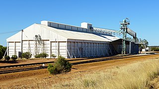
Bruce Rock is a town in the eastern Wheatbelt region of Western Australia, approximately 243 kilometres (151 mi) east of Perth and 48 kilometres (30 mi) southwest of Merredin. It is the main town in the Shire of Bruce Rock.

Beacon, Western Australia Town in Western Australia

Beacon is a town in Western Australia, in the Shire of Mount Marshall. It is 42 km (26 mi) north of Bencubbin and 333 km (207 mi) northeast of Perth by road.

Trayning, Western Australia Town in Western Australia

Trayning is a town in the north-eastern Wheatbelt region of Western Australia, 236 kilometres (147 mi) east of the state capital, Perth, on the Nungarin–Wyalkatchem Road. At the 2006 census, Trayning had a population of 122.

Ardath, Western Australia Town in Western Australia

Ardath is a small town in the Wheatbelt region of Western Australia 20 kilometres (12 mi) south of the town of Bruce Rock.

Fyodor Konyukhov Russian artist and explorer

Fyodor Filippovich Konyukhov is a Russian survivalist, voyager, aerial and marine explorer, and artist. In December 2010, he was ordained as an Eastern Orthodox priest in the Ukrainian Orthodox Church.

Lake King, Western Australia Town in Western Australia

Lake King is a town in the eastern Wheatbelt region of Western Australia, 464 kilometres (288 mi) from Perth along State Route 40 between Kelmscott and Ravensthorpe. As of 2016, the town had a population of 95. The 2011 census recorded both the population of the town and the surrounding area for a population of 332.

Kulja, Western Australia Town in Western Australia

Kulja is a small town in the Wheatbelt region of Western Australia. The town is situated along the Bonnie Rock to Burakin Road.

Pingaring, Western Australia Town in Western Australia

Pingaring is a small town in the Wheatbelt region of Western Australia.

Shackleton, Western Australia Town in Western Australia

Shackleton is a small town in the Wheatbelt region of Western Australia.

Yorkrakine Town in Western Australia

Yorkrakine is a small town in the Wheatbelt region of Western Australia; it is part of the Shire of Tammin, 203 kilometres (126 mi) east of the state capital, Perth. At the 2006 census, Yorkrakine had a population of 117.

Rozière balloon

A Rozière balloon is a type of hybrid balloon that has separate chambers for a non-heated lifting gas as well as for a heated lifting gas. The design was created by Jean-François Pilâtre de Rozier (1754–1785).

Wialki, Western Australia Town in Western Australia

Wialki is a townsite in the eastern Wheatbelt region of Western Australia. It is situated between Beacon and Bonnie Rock.

Muntadgin, Western Australia Town in Western Australia

Muntadgin is a townsite off the Great Eastern Highway on Brissenden Road, situated between the towns of Bruce Rock and Southern Cross in the Wheatbelt region of Western Australia. At the 2016 census, Muntadgin had a population of 51.

References

  1. Australian Bureau of Statistics (25 October 2007). "Bonnie Rock (State Suburb)". 2006 Census QuickStats. Retrieved 2 October 2008.
  2. Western Australian Land Information Authority. "History of country town names – B" . Retrieved 2 October 2008.
  3. The Bonnie Rock - Lake Brown - Mukinbudin leader, Wheatbelt Press, 1934, retrieved 5 December 2018
  4. "CBH Receival Sites - Contact Details" (PDF). 2010. Archived from the original (PDF) on 18 March 2012. Retrieved 31 March 2013.
  5. "Russian adventurer Fedor Konyukhov breaks world hot air balloon record, lands safety in WA" . Retrieved 24 July 2016.