
Wagin is a town and shire in the Wheatbelt region of Western Australia, approximately 225 km (139.81 mi) south-east of Perth on the Great Southern Highway between Narrogin and Katanning. It is also on State Route 107. The main industries are wheat and sheep farming.

Narrogin is a large town in the Wheatbelt region of Western Australia, 192 kilometres (119 mi) southeast of Perth on the Great Southern Highway between Pingelly and Wagin. In the age of steam engines, Narrogin was one of the largest railway operation hubs in the southern part of Western Australia.

Darkan is a town in the Wheatbelt region of Western Australia, between Collie and the Albany Highway on the Coalfields Highway. It is also the seat of the Shire of West Arthur. At the 2016 census, Darkan had a population of 403.

Williams is a town located in the Wheatbelt region of Western Australia, 161 kilometres (100 mi) south-southeast of the state capital, Perth along Albany Highway and 32 kilometres (20 mi) west of Narrogin. The Williams River passes through the town. At the 2016 census, Williams had a population of 411.

Wickepin is a town in the Wheatbelt region of Western Australia, 214 kilometres (133 mi) south-east of Perth and 38 kilometres (24 mi) east of Narrogin. Wickepin had a population of 380 at the 2021 census.

Kulin is a town in the eastern Wheatbelt region of Western Australia, approximately 280 km from Perth. It is the main town in the Shire of Kulin.
Cuballing is a town located in the Wheatbelt region of Western Australia, on Great Southern Highway, between Pingelly and Narrogin. At the 2021 census, Cuballing had a population of 456.
Yilliminning is a small town located in the southern Wheatbelt region of Western Australia, 212 kilometres (132 mi) southeast of the state capital, Perth and 23 kilometres (14 mi) east of Narrogin. At the 2006 census, Yilliminning had a population of 337.
Popanyinning is a small town in the Wheatbelt region of Western Australia, along Great Southern Highway between Pingelly and Narrogin. At the date of the 2016 census, Popanyinning had a population of 180.

Yornaning is a small town located in the Wheatbelt region of Western Australia, on Great Southern Highway, between Pingelly and Narrogin.

Pingelly is a town and shire located in the Wheatbelt region of Western Australia, 158 kilometres (98 mi) from Perth via the Brookton Highway and Great Southern Highway. The town is also located on the Great Southern railway line.

The Shire of Beverley is a local government area in the Wheatbelt region of Western Australia about 130 kilometres (80 mi) southeast of Perth, the state capital. The Shire covers an area of 2,372 square kilometres (916 sq mi), starting 20 kilometres (12 mi) outside Armadale in the Darling Scarp and extending eastwards beyond the scarp into agricultural lands which support broad acre activities such as livestock and cropping. Its seat of government is the town of Beverley, which accommodates just over half of the Shire's population.

The Shire of Pingelly is a local government area in the Wheatbelt region of Western Australia, about 160 kilometres (99 mi) southeast of the state capital, Perth, between the Shires of Brookton and Cuballing along the Great Southern Highway. The Shire covers an area of 1,295 square kilometres (500 sq mi), and its seat of government is the town of Pingelly.
The Shire of Narrogin is a local government area in the Wheatbelt region of Western Australia, about 190 kilometres (118 mi) south-east of the state capital, Perth. The seat of government is in the town of Narrogin. Until 2016, when the two entities merged, the Narrogin townsite was governed by a separate local government area, the Town of Narrogin.

The Shire of Cuballing is a local government area in the Wheatbelt region of Western Australia. Cuballing is located 15.1 kilometres (9 mi) north of the town of Narrogin and 192 kilometres (119 mi) southeast of the capital, Perth. The Shire covers an area of 1,195 square kilometres (461 sq mi) and its seat of government is the small town of Cuballing.
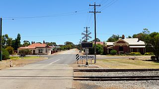
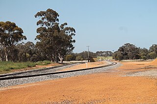
Piesseville is a small town in the Wheatbelt region of Western Australia, 211 kilometres (131 mi) south-east of Perth on the Great Southern Highway between Narrogin and Wagin. It is also on the Great Southern Railway. At the 2016 census, Piesseville had a population of 59.

The Shire of Kojonup is a local government area in the Great Southern region of Western Australia, about 250 kilometres (155 mi) southeast of the state capital, Perth, along Albany Highway. The Shire covers an area of 2,932 square kilometres (1,132 sq mi) and its seat of government is the town of Kojonup.

The Shire of Collie is a local government area in the South West region of Western Australia, about 60 kilometres (37 mi) east of Bunbury and about 200 kilometres (124 mi) south of the state capital, Perth. The Shire covers an area of 1,711 square kilometres (661 sq mi), and its seat of government is the town of Collie.

The Shire of Cranbrook is a local government area in the Great Southern region of Western Australia, about 92 kilometres (57 mi) north of Albany and about 320 kilometres (200 mi) south-southeast of the state capital, Perth. The Shire covers an area of 3,277 square kilometres (1,265 sq mi), and its seat of government is the town of Cranbrook.

The City of Kalgoorlie–Boulder is a local government area in the Goldfields–Esperance region of Western Australia, about 550 kilometres (342 mi) east of the state capital, Perth. Covering an area of 95,575 square kilometres (36,902 sq mi), the city is larger than the country of Portugal with a land area of 92,212 square kilometres (35,603 sq mi). Its seat of government is the town of Kalgoorlie; all but 244 of the city's population live in either Kalgoorlie or Boulder.


