
Northam is a town in the Australian state of Western Australia, situated at the confluence of the Avon and Mortlock Rivers, about 97 kilometres (60 mi) east-northeast of Perth in the Avon Valley. At the 2016 census, Northam had a population of 6,548. Northam is the largest town in the Avon region. It is also the largest inland town in the state not founded on mining.

Toodyay, known as Newcastle between 1860 and 1910, is a town on the Avon River in the Wheatbelt region of Western Australia, 85 kilometres (53 mi) north-east of Perth. The first European settlement occurred in the area in 1836. After flooding in the 1850s, the townsite was moved to its current location in the 1860s. It is connected by railway and road to Perth. During the 1860s, it was home to bushranger Moondyne Joe.
The Werribee railway line is a commuter rail passenger train service in Melbourne, Australia, operating between Werribee in the western suburbs to Flinders Street in the central business district. The line traverses the flat plains of Melbourne's western suburbs, and after leaving Footscray, has no significant earthworks. The area around the outer end of the line has seen significant residential growth in recent years, resulting in strong patronage growth. It is part of the Melbourne metropolitan rail network operated by Metro Trains.

Peterborough is a town in the mid north of South Australia, in wheat country, just off the Barrier Highway. At the 2016 census, Peterborough had a population of 1,419. It was originally named Petersburg after the landowner, Peter Doecke, who sold land to create the town. It was one of 69 places in South Australia renamed in 1917 due to anti-German sentiments during World War I.

The Wheatbelt is one of nine regions of Western Australia defined as administrative areas for the state's regional development, and a vernacular term for the area converted to agriculture during colonisation. It partially surrounds the Perth metropolitan area, extending north from Perth to the Mid West region, and east to the Goldfields-Esperance region. It is bordered to the south by the South West and Great Southern regions, and to the west by the Indian Ocean, the Perth metropolitan area, and the Peel region. Altogether, it has an area of 154,862 square kilometres (59,793 sq mi).
Spencers Brook is a waterway, locality and a district located within the Avon Valley in Western Australia.

Goomalling is a townsite in the Wheatbelt region of Western Australia, 45 kilometres north-north-east of Northam, Western Australia.
Grass Valley is a small townsite 13 kilometres (8 mi) east of Northam, Western Australia in the Avon Valley area.

New Lynn railway station is on the Western Line of the Auckland railway network, New Zealand, and is part of an integrated transport centre where transfers can be made to and from bus services. A redeveloped station in a new rail trench was opened on 25 September 2010. LynnMall, a major shopping mall, is close by.

Weston-super-Mare railway station serves the seaside town of Weston-super-Mare in North Somerset, England. It is situated on a loop off the main Bristol to Taunton Line, 137 miles 33 chains from the zero point at London Paddington via Box.

Hamilton railway station is a heritage-listed railway station on the Newcastle line in the inner Newcastle suburb of Hamilton in New South Wales, Australia. It was added to the New South Wales State Heritage Register on 2 April 1999.

Blanchetown is a small township in South Australia, on the (west) bank of the Murray River, 130 kilometres (81 mi) northeast of Adelaide. The Blanchetown Bridge is the westernmost of the four crossings of the Sturt Highway over the Murray River. During the nineteenth century it was an important transportation centre on the lower Murray. In the early 21st century, Blanchetown has been described as "a strange mixture of historic buildings and temporary shacks built by holidaymakers on the banks of the river". Blanchetown is widely regarded as the entrance to the Riverland district.

Southampton Terminus railway station served the Port of Southampton and Southampton City Centre, England from 1839 until 1966. The station was authorised on 25 July 1834 and built as the terminus of the London and Southampton Railway, which later changed its name to the London and South Western Railway (LSWR). The station opened as "Southampton" on 10 June 1839, although it was not officially operational until 11 May 1840, due to the track not being fully linked between Winchester and Basingstoke.

Clackline is a locality in the Wheatbelt region of Western Australia, about 80 kilometres (50 mi) east-north-east of Perth.

The East Maitland–Morpeth railway is a closed branch railway in New South Wales, Australia.
Clackline Bridge is a road bridge in Clackline, Western Australia, 77 kilometres (48 mi) east of Perth in the Shire of Northam, that carried the Great Eastern Highway until 2008. It is the only bridge in Western Australia to have spanned both a waterway and railway, the Clackline Brook and the former Eastern Railway alignment. The mainly timber bridge has a unique curved and sloped design, due to the difficult topography and the route of the former railway. The bridge was designed in 1934 to replace two dangerous rail crossings and a rudimentary water crossing. Construction began in January 1935, and was completed relatively quickly, with the opening ceremony held in August 1935. The bridge has undergone various improvement and maintenance works since then, including widening by three metres (10 ft) in 1959–60, but remained a safety hazard, with increasing severity and numbers of accidents through the 1970s and 1980s. Planning for a highway bypass of Clackline and the Clackline Bridge began in the 1990s, and it was constructed between January 2007 and February 2008. The local community had been concerned that the historic bridge would be lost, but it remains in use as part of the local road network, and has been listed on both the Northam Municipal Heritage Inventory and the Heritage Council of Western Australia's Register of Heritage Places.

Highways and main roads in the Wheatbelt region of Western Australia form the basis of a road network, which is primarily used by the mining, agriculture, and tourism industries. Main Roads Western Australia maintains and controls these major roads, with offices based in Northam and Narrogin.

Northam railway station is located in Northam on the Eastern Railway route in Western Australia. It is the second and more recent railway station in Northam.
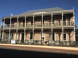
The Imperial Hotel was the first hotel to be built in York, Western Australia that adopted the new "Australian hotel" style in hotel design, with a dominant position on a main street corner block, high and ornate double verandahs surrounding the façade and a main entrance onto the street. The building is in Victorian Filigree style.

Northam Post Office is a heritage-listed post office at 239-243 Fitzgerald Street, Northam, Western Australia, Australia. It was added to the Australian Commonwealth Heritage List on 22 June 2004.

