Related Research Articles

Toodyay, known as Newcastle between 1860 and 1910, is a town on the Avon River in the Wheatbelt region of Western Australia, 85 kilometres (53 mi) north-east of Perth. The first European settlement occurred in the area in 1836. After flooding in the 1850s, the townsite was moved to its current location in the 1860s. It is connected by railway and road to Perth. During the 1860s, it was home to bushranger Moondyne Joe.
Daniel Connor was an Irish convict transported to the colony in western Australia, who would go on to became one of the wealthiest, and most successful men in the region.
The Shire of Toodyay is a local government area in the Wheatbelt region of Western Australia, beyond the north-eastern limits of the Perth metropolitan area. The Shire covers an area of 1,694 square kilometres (654 sq mi), and its seat of government is the town of Toodyay.

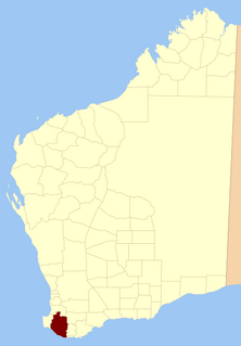
Sussex Land District is a land district of Western Australia, located within the South-West Land Division on the state's west coast. It covers the south-western corner of the state and includes the townsites of Busselton, Margaret River and Augusta as well as Cape Naturaliste and Cape Leeuwin.
Nelson Land District is a land district of Western Australia, located within the South West Division on the state's south coast. It covers part of the state's Lower South West region and includes the townsites of Bridgetown, Manjimup, Pemberton, Northcliffe and Nannup as well as Point D'Entrecasteaux and, at its far southeastern corner, Walpole.

Wellington Land District is a land district of Western Australia, located within the South-West Land Division on the state's west coast. It spans roughly 32°56'S - 33°40'S in latitude and 115°25'E - 116°50'E in longitude.
The Clackline to Miling railway branch, originally known as the Clackline to Newcastle railway line, is a railway line in Western Australia.
The Municipality of Newcastle was a local government area in the Wheatbelt region of Western Australia, about 85 kilometres (53 mi) north-east of Perth. The municipality covered an area of 395 acres (1.60 km2), existed from 1877 until 1912, and was based in the town of Toodyay, which was known as Newcastle until 1910.

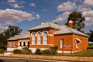
Butterly House, also known as Monger's Cottage, is located at 1A-D Harper Road, Toodyay, Western Australia. The building was the location of the first bank in Toodyay.

The Victoria Hotel is located on Stirling Terrace in Toodyay, Western Australia. It was classified by the National Trust of Australia in 1977 and added to the Register of National Estates in 1980.
Gabyon Station, commonly referred to as Gabyon, is a pastoral lease that operates as a sheep station in Western Australia.

The Newcastle–Bolgart Railway was the second stage of the Clackline–Miling railway. It was opened on 6 December 1909 by the Western Australian Premier Newton Moore. The line ran between Newcastle and Bolgart, Western Australia. The line came about after community support rallied against the Government, who were seen as not approving the rail to reduce the value of the Midland Railway Company land holdings. At a meeting on 6 November 1906 local MLA Timothy Quinlan then Speaker of the Western Australian Legislative Assembly threatened to resign from the government and join the opposition. The meeting proposed that Quinlan should meet with Moore and obtain a definitive answer as to whether he would include the line on the schedule of proposed railways.

The town of Toodyay, Western Australia, was not always known by that name. Initially Toodyay was located in what is now West Toodyay before repeated flooding caused the town centre to migrate to the area around the Newcastle convict depot creating the town of Newcastle. After approximately 50 years of confusion the name of Newcastle was changed to Toodyay and the original Toodyay became known as West Toodyay.

West Toodyay was the original location of the town of Toodyay, Western Australia. It is situated in the Toodyay valley, 85 kilometres (53 mi) north east of Perth. The Toodyay valley, discovered by Ensign Robert Dale in 1831, was opened up for settlement in 1836. The original site for the town of Toodyay was determined in 1836 and its boundaries were finalized 1838. The first survey of the town was carried out in 1849. After several serious floods, the decision was made to move the town of Toodyay to higher ground. In 1860, the new town of Newcastle was established 3 miles (4.8 km) further upstream. Newcastle was renamed in 1910 to Toodyay, and the original site became known as West Toodyay.

Toodyay railway station is located on the Eastern Railway in the Avon River town of Toodyay in Western Australia.

The Toodyay Valley School was the first government school in Toodyay. It opened on 1 October 1855 with 55 children enrolled. Boarders were received on moderate terms.
James Forbes (1828-1906) was an Enrolled Pensioner Guard who had arrived in the Swan River Colony in Western Australia aboard Pyrenees on 28 June 1851. Formerly a private of the 77th Regiment, he was 23 years of age. Soon after he was stationed at Toodyay, his pension expired and he was dismissed. A request for reinstatement was denied him. For a while, Forbes earned a living as a carter.

The Royal Oak established in 1853 by John Herbert was the second inn of that name in West Toodyay. It was also known as Herbert's Hotel. It stood on lot R11, upstream from where the first Royal Oak had been until it closed in November 1851.
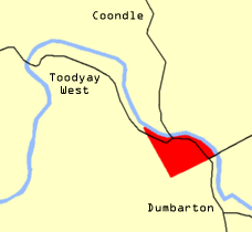
Toodyay valley is an older term for the section of the Avon River valley in Western Australia, where the town of Toodyay, and its original site are located.
Construction of the new Toodyay Convict Hiring Depot began in February 1852 and was completed by 1856. The depot was closed in 1872. The site chosen, Avon Location 110, was an area of Crown land measuring just over 45 acres (18 ha). It was situated approximately 3 miles (4.8 km) upstream from the site of the previous Toodyay Convict Hiring Depot (1851) located at the Toodyay townsite. The previous depot had only ever been a temporary arrangement born of necessity when accommodation was required at short notice. The new depot site was surveyed by Francis Thomas Gregory in 1852.
References
- 1 2 3 4 5 6 7 "THE TOODYAY VALLEY". The West Australian . Perth: National Library of Australia. 23 February 1898. p. 7. Retrieved 15 February 2014.
- ↑ Western Australia. Dept. of Lands and Surveys (1901), Coondle For sale under the provisions of the Agricultural Land purchase Act, The Dept, retrieved 15 February 2014
- 1 2 Frayne, Beth (2011). The Liong Toodyay Chronology Part 1, 1829-1900 (2nd ed.). Toodyay Historical Society.
- ↑ Old Toodyay and Newcastle, page 25 and Toodyay Homesteads pg93-97
- ↑ "NEWCASTLE". Western Mail . Perth: National Library of Australia. 12 November 1897. p. 24. Retrieved 16 February 2014.
- ↑ "AGRICULTURAL LANDS PURCHASE ACT". The West Australian . Perth: National Library of Australia. 27 June 1898. p. 7. Retrieved 16 February 2014.
- 1 2 "THE LAND QUESTION". The Daily News . Perth: National Library of Australia. 30 April 1898. p. 5. Retrieved 16 February 2014.
- ↑ Western Australia. Dept. of Lands and Surveys (1898), Coondle will be open for selection...13 April 1898, The Dept., retrieved 16 February 2014
- ↑ "THE REPURCHASED ESTATES". The West Australian . Perth: National Library of Australia. 13 July 1905. p. 2. Retrieved 16 February 2014.