Soakage (source of water)

Last updated

A soakage, or soak, is a source of water in Australian deserts.

Contents

It is called thus because the water generally seeps into the sand, and is stored below, sometimes as part of an ephemeral river or creek.

Aboriginal water source

Soakages were traditionally important sources of water for Aboriginal Australians in the desert, being the most dependable source in times of drought in Australia.

Aboriginal peoples would scoop out the sand or mud using a coolamon or woomera, often to a depth of several metres, until clean water gathered in the base of the hole. Knowing the precise location of each soakage was extremely valuable knowledge. It is also sometimes called a native well.

Anthropologist Donald Thomson wrote:

For a white man the difficulty in this country is that there is no way in which he can find the wells and soaks unless he does so by chance, and certainly nothing to indicate that the well is there, nor as a rule, even when the terrain and at least its superficial geological formation, the lie of the country, is examined, is there anything to explain the presence of water when he does find it

...

A lifetime of experience, backed by the traditional knowledge that is handed down from generation to generation, enables these people [the Pintupi in this instance] to judge, without having to visit a well that they know, whether it will still contain water and whether, if dry, with the sides fallen in and the well full of debris, it is worth cleaning out. [1] :85

Cleaning and maintaining the well

Wells were covered to keep them free from fouling by animals. This involved blocking the well with dead branches and uprooted trees. When the wells fell into disrepair, people would bail the well, using the coolamon to throw slush against the wall. This would set like a cement wash and help to hold loose sand, preventing it from falling into the water.

Wells could be up to fifteen feet deep, with small toe holds cut into the walls. [1] :23

Recording well locations

Donald Thomson writes:

Just before we left, the old men recited to me the names of more than fifty waters – wells, rockholes and claypans ... this, in an area that the early explorers believed to be almost waterless, and where all but a few were, in 1957, still unknown to the white man. And on the eve of our going, Tjappanongo (Tjapanangka) produced spear-throwers, on the backs of which were designs deeply incised, more or less geometric in form. Sometimes with a stick, or with his finger, he would point to each well or rock hole in turn and recite its name, waiting for me to repeat it after him. Each time, the group of old men listened intently and grunted in approval – "Eh!" – or repeated the name again and listened once more. This process continued with the name of each water until they were satisfied with my pronunciation, when they would pass on to the next. I realized that here was the most important discovery of the expedition – that what Tjappanongo and the old men had shown me was really a map, highly conventionalized, like the works on a "message" or "letter" stick of the Aborigines, of the waters of the vast terrain over which the Bindibu hunted. [2]

White explorers and the wells

In the nineteenth century, both Warburton and Carnegie recorded that they had run down Aboriginal residents with camels and captured and chained them to compel them to reveal their secret sources of water. This action left a lasting impression on Aboriginal residents of desert regions, who would have handed accounts of this down through successive generations. [1] :7

In the 1930s, when H. H. Finlayson made his journeys through the desert by camel, he noted that a gelded male camel, after a hard three-and-a-half-day journey in intense heat without water, drank 150 litres (33 imperial gallons) by actual measure without stopping, and fifteen minutes later, another 45 L (10 imp gal).

This sheds light on the resentment built up among the Aboriginal population against explorers for the exploitation and, by enlarging well entrances and digging out springs, the devastation of their precious water supplies to satisfy camel teams. [1] :135

Don McLeod (Aboriginal rights activist, see Pilbara) also tells a story of clashes over soak water at the time of the gold rushes in Western Australia:

During the time of the Laverton rush, the Blackfellows tried to keep their meager water supplies hidden from the knowledge of white prospectors since their horses and camels quickly exhausted the limited soaks.

McLeod relates a story told to him by an old prospector by the name of Long, observing an Aboriginal man and woman:

The man took the throwing stick he was carrying and worked it into the sand. He then broke off a hollow reed and, placing it in the hole he had thus developed, lay down on his stomach and appeared to suck up something through the reed. His companion repeated his movements before they quietly moved on...

Without delay Long, with the aid of a shovel, proved the existence of a soak of sweet water, from which he replenished his supplies...Only a few days later in the same place, another prospector had the same Blackfellow bailed up, threatening to shoot him unless he revealed a source of water. This was certainly not an untypical bush encounter. However, [they were] interrupted by yet another prospector riding a camel. The Blackfellow took advantage of the confusion and threw a spear into the bush and escaped.

On the diggings, a hue and cry was raised over this alleged murderous attack and a party was quickly organised to set out and teach the Blackfellows a lesson – for daring to protect their water. Mustering what guns they could, the punitive party went out to what later became known as Skull Creek, and shot every Blackfellow they could find. The bodies were buried in shallow graves. [3]

See also

Related Research Articles

<span class="mw-page-title-main">Canning Stock Route</span> Track in Western Australia

The Canning Stock Route is a track that runs from Halls Creek in the Kimberley region of Western Australia to Wiluna in the mid-west region. With a total distance of around 1,850 km (1,150 mi) it is the longest historic stock route in the world.

<span class="mw-page-title-main">Munga-Thirri National Park</span> Protected area in Queensland, Australia

Munga-Thirri National Park, formerly known as the Simpson Desert National Park, is the largest national park in Queensland, Australia, 1,495 km west of Brisbane. The park covers an area of 10,120 square kilometres (3,910 sq mi) in the Simpson Desert surrounding Poeppel Corner in the west of the locality of Birdsville in the Central West region of Queensland.

Lasseter's Reef refers to the purported discovery, announced by Harold Bell Lasseter in 1929 and 1930, of a fabulously rich gold deposit in a remote and desolate corner of central Australia. Lasseter's accounts of the find are conflicting and its precise location remains a mystery—if it exists.

<span class="mw-page-title-main">David Carnegie (explorer)</span> English explorer in Western Australia

The Hon. David Wynford Carnegie was an explorer and gold prospector in Western Australia. In 1896 he led an expedition from Coolgardie through the Gibson and Great Sandy Deserts to Halls Creek, and then back again.

<span class="mw-page-title-main">Ooldea, South Australia</span> Town in South Australia

Ooldea, known as Yuldea and various other names by Western Desert peoples (Aṉangu), is a tiny settlement in South Australia. It is on the eastern edge of the Nullarbor Plain, 863 km (536 mi) west of Port Augusta on the Trans-Australian Railway. Ooldea is 143 km (89 mi) from the bitumen Eyre Highway.

<span class="mw-page-title-main">Lake Mackay</span> Ephemeral salt lake in Western Australia and Northern Territory, Australia

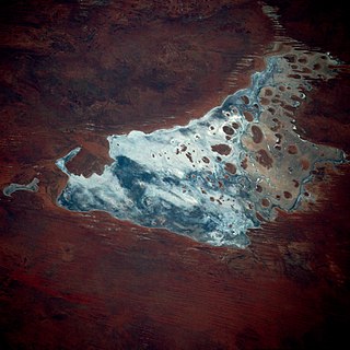
Lake Mackay, known as Wilkinkarra to the Indigenous Pintupi people, is the largest of hundreds of ephemeral salt lakes scattered throughout the Pilbara and northern parts of the Goldfields-Esperance region of Western Australia and the Northern Territory. It is located on the edge of the Great Sandy Desert.

<span class="mw-page-title-main">Donald Thomson</span> Australian anthropologist and ornithologist (1901–1970)

Donald Finlay Fergusson Thomson OBE was an Australian anthropologist and ornithologist. he is known for his studies of and friendship with the Pintupi and Yolngu peoples, and for his intervention in the Caledon Bay crisis.

Aputula is a remote Indigenous Australian community in the Northern Territory of Australia. It is 317 km (197 mi) south of Alice Springs and 159 km (99 mi) east of Kulgera roadhouse on the Stuart Highway, near the border with South Australia. The Finke River, which is dry for most of the year except during occasional floods and is part of the Lake Eyre basin, passes within a few kilometres of the community.

The Coniston massacre, which took place in the region around the Coniston cattle station in the then Territory of Central Australia from 14 August to 18 October 1928, was the last known officially sanctioned massacre of Indigenous Australians and one of the last events of the Australian Frontier Wars.

<span class="mw-page-title-main">Australian feral camel</span> Feral camels in Australia, descended from animals imported in 19th century

Australian feral camels are introduced populations of dromedary, or one-humped, camel. Imported as valuable beasts-of-burden from British India and Afghanistan during the 19th century, many were casually released into the wild after motorised transport negated the use of camels in the early 20th century. This resulted in a fast-growing feral population with numerous ecological, agricultural and social impacts.

<span class="mw-page-title-main">Bindibu expedition</span>

The Bindibu expedition was a series of three field trips mounted by anthropologist Donald Thomson to meet with and learn from Pintupi Indigenous Australians between 1957 and 1965.

<span class="mw-page-title-main">Message stick</span>

A message stick is a public communication device used by Aboriginal Australians. The objects were carried by messengers over long distances and were used for reinforcing a verbal message. Although styles vary, they are generally oblong lengths of wood with motifs engraved on all sides. They have traditionally been used across continental Australia, to convey messages between Aboriginal nations, clans and language groups. In the 1880s, they became objects of anthropological study, but there has been little research on them published since then. Message sticks are non-restricted since they were intended to be seen by others, often from a distance. They are nonetheless frequently mistaken for tjurungas.

<span class="mw-page-title-main">Coolamon (vessel)</span> Australian Aboriginal carrying vessel

Coolamon is an anglicised version of the Wiradjuric word guliman used to describe an Australian Aboriginal carrying vessel.

<span class="mw-page-title-main">David Lindsay (explorer)</span>

David Lindsay was an Australian explorer and surveyor and a fellow of the Royal Geographical Society, London.

<span class="mw-page-title-main">The Dreamtime Duck of the Never-Never</span>

"The Dreamtime Duck of the Never Never" is a 1993 Scrooge McDuck comic by Don Rosa. It is the seventh of the original 12 chapters in the series The Life and Times of Scrooge McDuck. The story takes place from 1893 to 1896.

<span class="mw-page-title-main">Duncan McIntyre (explorer)</span>

Duncan McIntyre was an Australian explorer who followed in the tracks of Burke and Wills. In 1864 he laid claim to the property now called Dalgonally in North-West Queensland, and found evidence of Ludwig Leichhardt's final expedition. He subsequently led a party in search of Leichhardt, but died of fever during the search.

The Kelly Hills are a mountain range at the southern end of the Northern Territory of Australia. It is located in the locality of Petermann directly north of the Musgrave Ranges and about 50 kilometres (31 mi) northeast of Amaṯa in South Australia. Its highest point is about 870 metres (2,850 ft) above sea level. Mount Robert, at the eastern end of the range, is about 796 metres (2,612 ft) above sea level. The area is known as Aputjilpinya in the native Yankunytjatjara language. It forms part of an important Mala Dreaming track that runs between Uluṟu and Ulkiya.

<span class="mw-page-title-main">Tjunti</span> Soakage in the Northern Territory, Australia

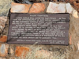
Tjunti is a soakage site near Kaḻṯukatjara, in the Northern Territory of Australia. It is located where the Hull River cuts through the Petermann Ranges, about 36 kilometres (22 mi) to the southeast of Kaḻṯukatjara, 41 km (25 mi) by road along the Tjukaruru Road. Tjunti is known as the site where the famous gold prospector Harold B. Lasseter took refuge on his fatal search for Lasseter's Reef. An outstation was established here in 1977, and belongs to a Pitjantjatjara family.

The Warnman, also spelt Wanman, are an Aboriginal Australian people of Western Australia's Pilbara region.

<span class="mw-page-title-main">Carnegie expedition of 1896</span> Western Australian exploration in 1896

The Carnegie expedition of 1896 was led by David Carnegie. It covered territory in the centre of Western Australia, including the Gibson and Great Sandy Deserts.

References

  1. 1 2 3 4 Thomson, Donald, Bindibu Country, Nelson Publishing, Melbourne, 1975.
  2. Thomson, Donald F., "The Bindibu Expedition: exploration among the desert Aborigines of Western Australia", The Geographical Journal, vol. 128, part 1 (March 1962), pp. 1–14, [143]–157, 262-278. [Q 306.0899915 THO]
  3. Don McLeod, How the West was Lost, self-published, Port Hedland, 1984, pp27-28