
Yalgoo is a town in the Mid-west region, 499 kilometres (310 mi) north-north-east of Perth, Western Australia and 118 kilometres (73 mi) east-north-east of Mullewa. Yalgoo is in the local government area of the Shire of Yalgoo.

Bolgart is a townsite north of Toodyay in Western Australia. It is in the Shire of Victoria Plains.

Tammin is a town in the central agricultural region of Western Australia, 184 kilometres (114 mi) east of Perth and midway between the towns of Cunderdin and Kellerberrin on the Great Eastern Highway.
Moorine Rock is located in the eastern agricultural region of Western Australia, 347 km east of Perth and 22 km west south west of Southern Cross.

Wubin is located in the northern Wheatbelt region of Western Australia, 272 kilometres (169 mi) north-northeast of Perth and 21 kilometres (13 mi) north of Dalwallinu.
Yerecoin is a small town located in the Wheatbelt region of Western Australia, in the Shire of Victoria Plains,156 kilometres (97 mi) north-northeast of the state capital, Perth.

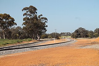
Doodlakine is a town 220 km (140 mi) east of Perth, Western Australia. It is within the Shire of Kellerberrin along the Great Eastern Highway. The town has a crossing loop for trains on the Perth-to-Kalgoorlie railway and serves as a stop on the MerredinLink rural train service.
Yilliminning is a small town located in the southern Wheatbelt region of Western Australia, 212 kilometres (132 mi) southeast of the state capital, Perth and 23 kilometres (14 mi) east of Narrogin. At the 2006 census, Yilliminning had a population of 337.
Muchea is a town in the Shire of Chittering, located 43 km (27 mi) north north-east of Perth. Its postcode is 6501. The town's name comes from the Aboriginal word "Muchela" which means in Nyoongar 'water hole', referring to the abundance of water in Muchea.

Badgingarra is a small town in the Wheatbelt region of Western Australia, about 205 kilometres (127 mi) north of Perth in the Shire of Dandaragan. It lies on the Brand Highway adjacent to the Badgingarra National Park.

Koorda is a town in the north eastern Wheatbelt region of Western Australia, approximately 236 kilometres (147 mi) east of Perth and 43 kilometres (27 mi) north of Wyalkatchem at the northeastern end of the Cowcowing Lakes. It is the main town in the Shire of Koorda. At the 2016 census Koorda had a population of 414. The surrounding areas produce wheat and other cereal crops. The town is a receival site for Cooperative Bulk Handling.

Regans Ford is a small town located in the Wheatbelt region of Western Australia, about 110 kilometres (70 mi) north of Perth in the Shire of Dandaragan.
Ajana is a townsite within the Shire of Northampton in Western Australia. It is located at the junction of Ajana-Kalbarri Road and Ajana Back Road, 53 kilometres (33 mi) by road north of Northampton, 61 kilometres (38 mi) by road southwest of Kalbarri, and 531 kilometres (330 mi) west-northwest of Perth in the Mid West region.

Kwolyin is a small town in the Wheatbelt region of Western Australia.
Manmanning is a small Wheatbelt town in Western Australia.
Munglinup is a small town located in the Shire of Ravensthorpe in the Goldfields–Esperance region of Western Australia.
Pingrup is a small town in the Great Southern region of Western Australia.
Wannamal is a town in the Wheatbelt region of Western Australia.

Watheroo is a small town in the Wheatbelt region of Western Australia. There are 137 residents, according to the 2021 census.
Needilup is a town in the Great Southern region of Western Australia, situated between Ongerup and Jerramungup along the Gnowangerup-Jerramungup Road.

