
Potash includes various mined and manufactured salts that contain potassium in water-soluble form. The name derives from pot ash, which refers to plant ashes or wood ash soaked in water in a pot, which was the primary means of manufacturing the product before the Industrial Era. The word "potassium" is derived from "potash".
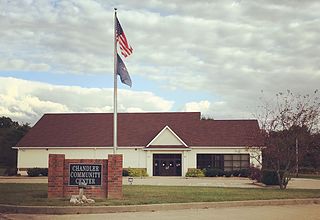
Chandler is a town straddling Ohio and Boon Township in Warrick County, Indiana, United States, located just east of Evansville, Indiana along the Ohio River. The population was 2,887 at the 2010 census. The town is part of the Evansville metropolitan area with a population of 342,815.

BHP, formerly known as BHP Billiton, is the trading entity of BHP Group Limited and BHP Group plc, an Anglo-Australian multinational mining, metals and petroleum dual-listed public company headquartered in Melbourne, Victoria, Australia.

Eidsvold is a rural town and locality in the North Burnett Region, Queensland, Australia. The town is the self-proclaimed Beef Capital of the Burnett and is a hub for the regional cattle industry. In the 2016 census, Eidsvold had a population of 574 people.

Iron Knob is a town in the Australian state of South Australia on the Eyre Peninsula immediately south of the Eyre Highway. At the 2006 census, Iron Knob and the surrounding area had a population of 199. The town obtained its name from its proximity to large deposits of iron ore, most notably Iron Monarch which outcropped prominently from the relatively flat, surrounding landscape.

Salmon Gums is a small town in Western Australia located 106 km north of Esperance on the Coolgardie-Esperance Highway. The name is derived from a prominent stretch of Eucalyptus salmonophloia trees which formed a landmark in the town's early days. The town is part of the Shire of Esperance. At the 2016 census, Salmon Gums had a population of 191.

Ravensthorpe is a town 541 km south-east of Perth and 40 km inland from the south coast of Western Australia. It is the seat of government of the Shire of Ravensthorpe. At the 2006 census, Ravensthorpe had a population of 438.

The Rural Municipality of Blucher No. 343 is a rural municipality (RM) in the Canadian province of Saskatchewan within Census Division No. 11 and SARM Division No. 5. It is located in the north-central portion of the province on the South Saskatchewan River.

Baralaba is a rural town and locality in the Shire of Banana in central Queensland, Australia. In the 2016 census, Baralaba had a population of 314 people.

Silver Peak is an unincorporated community and census-designated place (CDP) in Esmeralda County, Nevada, United States. It lies along State Route 265, 20 miles (32 km) south of U.S. Route 6 and 30 miles (48 km) west of Goldfield, the county seat of Esmeralda County. It has a post office, with the ZIP code of 89047. The population of Silver Peak was 115 as of 2018.

Hopetoun is a town on the south coast of Western Australia in the Shire of Ravensthorpe. Located on Mary Ann Harbour, Hopetoun is 590 kilometres (370 mi) south-east from capital city Perth and 160 kilometres (99 mi) west of Esperance.

Bulahdelah is a town and locality in the Hunter/Mid North Coast region of New South Wales, Australia in the Mid-Coast Council local government area. At the 2016 census, the locality had a population of 1,424. The main population centre, where 69% of the area's population lived in 2006, is the town of Bulahdelah.

Mining in Western Australia, together with the petroleum industry in the state, accounted for 94% of the State's and 41% of Australia's income from total merchandise exports in 2018–19. The state of Western Australia hosted 127 principal mining projects and hundreds of smaller quarries and mines. The principal projects produced more than 99 per cent of the industry's total sales value.

Sandstone is a small town in the Mid West region of Western Australia 157 kilometres (98 mi) east of Mount Magnet and 661 kilometres (411 mi) north of the state capital, Perth. At the 2016 census, Sandstone and the surrounding Shire of Sandstone had a population of 89 people, including 19 families. Sandstone is the administrative centre and only town in the Shire of Sandstone local government area.

Alunite is a ghost town located some 5 miles (8.0 km) south of Marysvale, near the mouth of Cottonwood Canyon in Piute County, Utah, United States. A small but important mining town during World War I, Alunite was inhabited from approximately 1915–1930.
Koolanooka is a small town in the MidWest region of Western Australia. It is situated between Morawa and Perenjori just off the Mullewa-Wubin road. At the 2006 census, Koolanooka had a population of 46.

Lake King is a town in the eastern Wheatbelt region of Western Australia, 464 kilometres (288 mi) from Perth along State Route 40 between Kelmscott and Ravensthorpe. As of 2016, the town had a population of 95. The 2011 census recorded both the population of the town and the surrounding area for a population of 332.
Gregory is a small town and fishing port located 7 km (4.3 mi) northwest of the mouth of the Hutt River, in the Mid West region of Western Australia. At the 2016 census, Gregory had a population of 64 in 83 dwellings. Most of the dwellings are holiday houses. The population of Gregory fluctuates depending on tourism; with the town at full capacity during school holidays and throughout the summer. During the census 50% of dwellings were unoccupied.
The economy of Saskatchewan has been associated with agriculture resulting in the moniker "Bread Basket of Canada" and Bread Basket of the World. According to the Government of Saskatchewan, approximately 95% of all items produced in Saskatchewan, depend on the basic resources available within the province. Various grains, livestock, oil and gas, potash, uranium, wood and their spin off industries fuel the economy.

Young is a village in the Canadian province of Saskatchewan within the Rural Municipality of Morris No. 312. The economy is dominated by local agriculture and the nearby Mosaic Potash mine.
