Walgoolan, Western Australia

Last updated

Walgoolan
Western Australia
Australia Western Australia location map.svg
Red pog.svg
Walgoolan
Walgoolan, Western Australia
Coordinates 31°23′00″S118°34′00″E / 31.38333°S 118.56667°E / -31.38333; 118.56667 Coordinates: 31°23′00″S118°34′00″E / 31.38333°S 118.56667°E / -31.38333; 118.56667
Population64 (SAL 2021) [1]
Established1923
Postcode(s) 6422
Elevation329 m (1,079 ft)
Area527.9 km2 (203.8 sq mi)
Location
LGA(s) Shire of Westonia
State electorate(s) Central Wheatbelt
Federal division(s) O'Connor

Walgoolan is a small town located in the eastern Wheatbelt region of Western Australia. It is situated between Merredin and Bodallin along the Great Eastern Highway.

Originating as a railway siding on the main eastern railway, Walgoolan was established between 1895 and 1899. Land was set aside for a townsite in 1913 and lots were surveyed in 1922. The townsite was gazetted in 1923. [2]

The name of the town is Aboriginal in origin and means place where the short bushes grow.

Following World War I, nearly 100 settlers took up land in the area, which were cleared and planted with cereal crops, mostly wheat. The town was a thriving community with five schools, tennis courts, a cricket club, Country Women's Association and Wheat Growers Union.

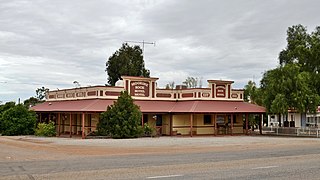
Tenders for the construction of a brick and cement hall in the town were called for in 1926. [3] The hall was opened and being used for recitals and other community events the following year. [4] The Westonia Road board held a referendum among the ratepayers to decide whether £500 of funding should be used to purchase the hall. The proposal was carried by a large majority. [5]

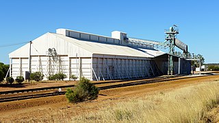
In 1932 the Wheat Pool of Western Australia announced that the town would have two grain elevators, each fitted with an engine, installed at the railway siding. [6]

In 1932, 30,000 emus migrated to the farm land around Walgoolan nearby, which would go on to start the Emu War, which changed the face of Australian farming, ravaging crops and destroying fences. The Australian military was deployed to fight these emus at the request of the farmers, in an unsuccessful attempt to lower the population of emus with machine guns.

The Great Depression and a succession of droughts took their toll on the area; by 1940 only one shop was left and the townsite was abandoned soon after. By 2010 only 10 families remain in the district.

A gazebo was erected in the town in 2010 to commemorate the early settlers and launch the book East of the Fence; the gazebo contains historic photographs and a list of the names of the pioneers. [7]

Related Research Articles

<span class="mw-page-title-main">Narembeen, Western Australia</span> Town in the Wheatbelt, Western Australia

Narembeen is a town in the Wheatbelt region of Western Australia. It is 286 km, almost due east, from Perth, the capital of WA. It is the major settlement in the Shire of Narembeen, in which the major industries are growing cereal crops and raising cattle and sheep. The surrounding areas produce wheat and other cereal crops. The town is a receival site for Cooperative Bulk Handling.

<span class="mw-page-title-main">Corrigin, Western Australia</span> Town in the Wheatbelt region of Western Australia

Corrigin is a town in the central Wheatbelt region of Western Australia, 229 kilometres (142 mi) east-southeast of the state capital, Perth, Western Australia, along State Route 40. It is mostly a farming community focused on crops and sheep, and holds the world record of "the most dogs in a ute".

<span class="mw-page-title-main">Newdegate, Western Australia</span> Town in Western Australia

Newdegate is a townsite in the Great Southern agricultural region, 399 km south-east of Perth and 52 km east of Lake Grace in Western Australia. The townsite was gazetted in 1925 and honours Sir Francis Newdegate, the Governor of Western Australia from 1920 to 1924. The Department of Agriculture and Food operates one of its 13 research stations in the area of Newdegate.

<span class="mw-page-title-main">Perenjori, Western Australia</span> Town in Western Australia

Perenjori is a townsite in the northern agricultural region, 348 kilometres (216 mi) north of Perth and 39 kilometres (24 mi) south-east of Morawa. It is located on the Wongan Hills to Mullewa railway line which was opened in 1915. Perenjori was approved as the name of a siding in April 1913, and later that year the government decided to establish a townsite there. Perenjori townsite was gazetted in 1916.

<span class="mw-page-title-main">Tammin, Western Australia</span> Town in Western Australia

Tammin is a town in the central agricultural region of Western Australia, 184 kilometres (114 mi) east of Perth and midway between the towns of Cunderdin and Kellerberrin on the Great Eastern Highway.

<span class="mw-page-title-main">Kellerberrin, Western Australia</span> Town in Western Australia

Kellerberrin is a town in the Wheatbelt region of Western Australia, 205 kilometres (127 mi) east of Perth on the Great Eastern Highway. The town serves as a stop on the Prospector and MerredinLink rural train services. It is also located on the Golden Pipeline Heritage Trail.

<span class="mw-page-title-main">Burracoppin, Western Australia</span> Town in Western Australia

Burracoppin is a townsite on the Great Eastern Highway, east of Merredin in the Wheatbelt region of Western Australia.

<span class="mw-page-title-main">Moorine Rock, Western Australia</span> Town in Western Australia

Moorine Rock is located in the eastern agricultural region of Western Australia, 347 km east of Perth and 22 km west south west of Southern Cross.

<span class="mw-page-title-main">Doodlakine, Western Australia</span> Town in the Wheatbelt region of Western Australia

Doodlakine is a town 220 km (140 mi) east of Perth, Western Australia. It is within the Shire of Kellerberrin along the Great Eastern Highway. The town has a crossing loop for trains on the Perth-to-Kalgoorlie railway and serves as a stop on the MerredinLink rural train service.

<span class="mw-page-title-main">Meckering, Western Australia</span> Town in Western Australia

Meckering is a town 130 kilometres (80.8 mi) east of Perth, Western Australia along the Great Eastern Highway. Meckering is located within the Shire of Cunderdin.

<span class="mw-page-title-main">Beacon, Western Australia</span> Town in Western Australia

Beacon is a town in Western Australia, in the Shire of Mount Marshall. It is 42 km (26 mi) north of Bencubbin and 333 km (207 mi) northeast of Perth by road.

<span class="mw-page-title-main">Trayning, Western Australia</span> Town in Western Australia

Trayning is a town in the north-eastern Wheatbelt region of Western Australia, 236 kilometres (147 mi) east of the state capital, Perth, on the Nungarin–Wyalkatchem Road. At the 2006 census, Trayning had a population of 122.

<span class="mw-page-title-main">Nungarin, Western Australia</span> Town in Western Australia

Nungarin is a town located in the north east of the Wheatbelt region of Western Australia, approximately 278 kilometres (173 mi) east of Perth and 39 kilometres (24 mi) north of Merredin. It is the main town in the Shire of Nungarin. At the 2006 census, Nungarin had a population of 142.

<span class="mw-page-title-main">Koorda, Western Australia</span> Town in Western Australia

Koorda is a town in the north eastern Wheatbelt region of Western Australia, approximately 236 kilometres (147 mi) east of Perth and 43 kilometres (27 mi) north of Wyalkatchem at the northeastern end of the Cowcowing Lakes. It is the main town in the Shire of Koorda. At the 2016 census Koorda had a population of 414. The surrounding areas produce wheat and other cereal crops. The town is a receival site for Cooperative Bulk Handling.

<span class="mw-page-title-main">Kulja, Western Australia</span> Town in the Wheatbelt region of Western Australia

Kulja is a small town in the Wheatbelt region of Western Australia. The town is situated along the Bonnie Rock to Burakin Road.

<span class="mw-page-title-main">Maya, Western Australia</span> Town in Western Australia

Maya is a small town in the Mid West region of Western Australia.

<span class="mw-page-title-main">Kununoppin</span> Town in Western Australia

Kununoppin is a small town in the Wheatbelt region of Western Australia. The town is located on the Nungarin–Wyalkatchem Road and in the Shire of Trayning local government area, 257 kilometres (160 mi) north east of the state capital, Perth, Western Australia. At the 2006 census, Kununoppin had a population of 151.

Bowgada is a small town in Western Australia located on the Mullewa Wubin Road 366 kilometres (227 mi) north of Perth in the Mid West region.

Bunjil is a small town in Western Australia located on the Mullewa Wubin Road 326 kilometres (203 mi) north of Perth in the Mid West region. At the 2021 census, it had a population of 61.

<span class="mw-page-title-main">Pintharuka, Western Australia</span> Town in Western Australia

Pintharuka is an abandoned townsite in the Mid West region of Western Australia. The town is located between the towns of Morawa and Mullewa on the Mullewa-Wubin Road

References

  1. Australian Bureau of Statistics (28 June 2022). "Walgoolan (Suburb and Locality)". Australian Census 2021 QuickStats. Retrieved 28 June 2022.  OOjs UI icon edit-ltr-progressive.svg
  2. "History of country town names – W". Western Australian Land Information Authority. Retrieved 20 April 2011.
  3. "Advertising". The West Australian . Perth: National Library of Australia. 25 October 1926. p. 1. Retrieved 4 October 2013.
  4. "Advertising". Western Mail . Perth: National Library of Australia. 25 August 1927. p. 28. Retrieved 4 October 2013.
  5. "Rural Interests". The West Australian . Perth: National Library of Australia. 14 August 1928. p. 7. Retrieved 4 October 2013.
  6. "Country elevators". The West Australian . Perth: National Library of Australia. 6 July 1932. p. 10. Retrieved 6 April 2013.
  7. "Walgoolan-Jilbadgee Memorial Gazebo". 2010. Retrieved 20 April 2011.