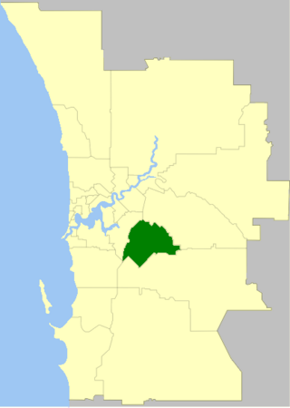
The City of Gosnells is a local government area in the southeastern suburbs of the Western Australian capital city of Perth, located northwest of Armadale and about 20 kilometres (12 mi) southeast of Perth's central business district. The City covers an area of 128 square kilometres (49.42 sq mi), a portion of which is state forest rising into the Darling Scarp to the east, and had a population of approximately 118,000 at the 2016 Census. The largest activity centre in the City is the Central Maddington shopping centre. District centres exist in the Gosnells town centre and Thornlie.

Cunderdin is a town located in the Wheatbelt region of Western Australia 156 km east of Perth, along the Great Eastern Highway. Due to it being on the route of the Goldfields Water Supply Scheme it is also on the Golden Pipeline Heritage Trail. It is a rural community consisting of a district high school and an agricultural college.

Corrigin is a town in the central Wheatbelt region of Western Australia, 229 kilometres (142 mi) east-southeast of the state capital, Perth, Western Australia, along State Route 40. It is mostly a farming community focused on crops and sheep, and holds the world record of "the most dogs in a ute".

Byford is a suburb on the south-eastern edge of Perth, Western Australia, within the Shire of Serpentine-Jarrahdale. The town has its origins in a township that was gazetted under the name "Beenup" in 1906. In 1920, the name of the township was changed to Byford.

Serpentine is a town located 55 kilometres (34 mi) south-southeast of Perth, the capital of Western Australia, and 7 km south of Mundijong.

Jarrahdale is a small historic town located 45 km south-east of Perth, Western Australia in the Darling Range. The name is derived from its situation in a jarrah forest. Established in the late 1800s as the state's first major timber milling operation, it played a key role in the development of Western Australia through the exportation of jarrah around the world. At the 2016 census, Jarrahdale had a population of 1,192. Since 2001, the historic precinct has been managed by the state's National Trust organisation alongside private residential and tourism-oriented developments.

Kulin is a town in the eastern Wheatbelt region of Western Australia, approximately 280 km from Perth. It is the main town in the Shire of Kulin.

The Shire of Kulin is a local government area in the eastern Wheatbelt region of Western Australia, about 300 kilometres (186 mi) ESE of the state capital, Perth. The Shire's land area of 4,714 square kilometres (1,820 sq mi) forms a narrow east-west band, located between the Shire of Kondinin to the north and the Shire of Lake Grace to the south. Its seat of government is the town of Kulin. The local economy is based on agriculture - predominantly cereal grains and sheep.

Kondinin is a town located in the eastern Wheatbelt region of Western Australia, 279 kilometres (173 mi) east of the state capital, Perth via the Brookton Highway and State Route 40 between Corrigin and Hyden. It is one of three towns in the Shire of Kondinin. At the 2006 census, Kondinin had a population of 311.

Macedon is a town at the foot of Mount Macedon in the Macedon Ranges, between Melbourne and Bendigo in central Victoria. It is administered by the Shire of Macedon Ranges. At the 2016 census Macedon had a population of 2,808. The combined population of Macedon and the nearby larger town of Gisborne was 21,071 at June 2016.

Wedge Island is a 400-metre long wedge shaped island north of Lancelin and south of Cervantes on the Western Australian coast. The island is located just south of “the point” and approximately 15km south-east of an informal settlement known as Grey village with which it often shares a name. Both are within the Shire of Dandaragan.
Ajana is a townsite within the Shire of Northampton in Western Australia. It is located at the junction of Ajana-Kalbarri Road and Ajana Back Road, 53 kilometres (33 mi) by road north of Northampton, 61 kilometres (38 mi) by road southwest of Kalbarri, and 531 kilometres (330 mi) west-northwest of Perth in the Mid West region.

Northbridge is an inner city suburb of Perth, Western Australia, historically separated from Perth's central business district by the Fremantle and Joondalup railway lines. It is part of the City of Perth local government area.
Brookton to Corrigin railway was a railway line in the Wheatbelt region of Western Australia, between Brookton and Corrigin.

The Roy Hill railway, officially the Roy Hill Infrastructure railway, owned and operated by Hancock Prospecting, is a private rail network in the Pilbara region of Western Australia built to carry iron ore.

Kulikup is a rural locality and small town of the Shire of Boyup Brook in the South West region of Western Australia.
Jitarning is a locality in the Shire of Kulin in Western Australia, with a population of 63 according to the 2021 Census.

Cardiff is a rural town in the Shire of Collie in the South West region of Western Australia.

The Merredin to Yilliminning railway line was a railway line connecting Merredin to Yilliminning via Kondinin. Also known as the West Merredin to Yilliminning via Kondinin railway, it was 260 kilometres (160 mi) long. At its northern end, at Merredin, it connected to the Eastern Goldfields Railway while, at the southern terminus at Yilliminning, it connected to the Merredin to Narrogin railway line. From Yilliminning, this line continued to Narrogin, 23 kilometres (14 mi) further west, where the line intersected the Great Southern Railway.

The Wagin to Newdegate railway line is a railway line in the Wheatbelt region of Western Australia, connecting Wagin via Lake Grace to Newdegate, where the line terminates. The line is 180 kilometres (110 mi) long. At Lake Grace, a 94-kilometre (58 mi) branch line to Hyden exists, while, at Wagin, the railway line connects to the Great Southern Railway. Formerly, at Wagin, it also connected to now inactive railway line to Bowelling.

