
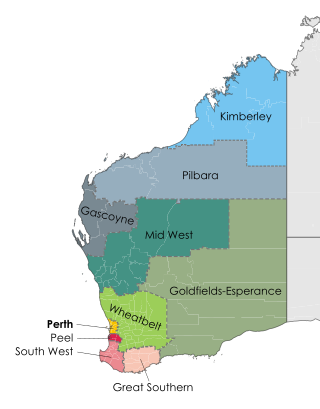
The Wheatbelt is one of nine regions of Western Australia defined as administrative areas for the state's regional development, and a vernacular term for the area converted to agriculture during colonisation. It partially surrounds the Perth metropolitan area, extending north from Perth to the Mid West region, and east to the Goldfields–Esperance region. It is bordered to the south by the South West and Great Southern regions, and to the west by the Indian Ocean, the Perth metropolitan area, and the Peel region. Altogether, it has an area of 154,862 square kilometres (59,793 sq mi).

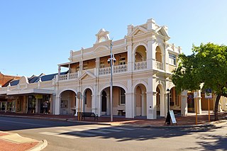
Narrogin is a town in the Wheatbelt region of Western Australia, 192 kilometres (119 mi) southeast of Perth on the Great Southern Highway between Pingelly and Wagin. In the age of steam engines, Narrogin was one of the largest railway operation hubs in the southern part of Western Australia.

The Division of O'Connor is an Australian electoral division in the state of Western Australia. It is one of Western Australia's three rural seats, and one of the largest electoral constituencies in the world.

Kulin is a town in the eastern Wheatbelt region of Western Australia, approximately 280 km from Perth. It is the main town in the Shire of Kulin.

The City of Perth is a local government area and body, within the Perth metropolitan area, which is the capital of Western Australia. The local government is commonly known as Perth City Council. The City covers the Perth city centre and surrounding suburbs. The City covers an area of 20.01 square kilometres (8 sq mi) and had an estimated population of 21,092 as at 30 June 2015. On 1 July 2016 the City expanded, absorbing 1,247 residents from the City of Subiaco.
Highbury, originally Wolwolling, is a small town in the Wheatbelt region of Western Australia, located along the Great Southern Highway between Narrogin and Wagin. At the 2006 census, Highbury had a population of 493.

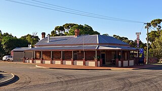
Harrismith is a small town in the Wheatbelt region of Western Australia, approximately 260 kilometres (162 mi) south-east of Perth between the towns of Wickepin and Kulin.

The Shire of Wickepin is a local government area in the Wheatbelt region of Western Australia, east of Narrogin and about 220 kilometres (137 mi) southeast of the state capital, Perth. The Shire covers an area of 2,042 square kilometres (788 sq mi), and its seat of government is the town of Wickepin.
The Shire of Narrogin is a local government area in the Wheatbelt region of Western Australia, about 190 kilometres (118 mi) south-east of the state capital, Perth. The seat of government is in the town of Narrogin. Until 2016, when the two entities merged, the Narrogin townsite was governed by a separate local government area, the Town of Narrogin.

The Shire of Cuballing is a local government area in the Wheatbelt region of Western Australia. Cuballing is located 15.1 kilometres (9 mi) north of the town of Narrogin and 192 kilometres (119 mi) southeast of the capital, Perth. The Shire covers an area of 1,195 square kilometres (461 sq mi) and its seat of government is the small town of Cuballing.

The Shire of Kulin is a local government area in the eastern Wheatbelt region of Western Australia, about 300 kilometres (186 mi) ESE of the state capital, Perth. The Shire's land area of 4,714 square kilometres (1,820 sq mi) forms a narrow east-west band, located between the Shire of Kondinin to the north and the Shire of Lake Grace to the south. Its seat of government is the town of Kulin. The local economy is based on agriculture - predominantly cereal grains and sheep.

The Shire of Kondinin is a local government area in the eastern Wheatbelt region of Western Australia, about 300 kilometres (186 mi) east of the state capital, Perth. The Shire's land area of 7,376 square kilometres (2,848 sq mi) forms a narrow east-west band, located between the Shire of Narembeen to the north and the Shire of Kulin to the south. Its seat of government is the town of Kondinin.

Kondinin is a town located in the eastern Wheatbelt region of Western Australia, 279 kilometres (173 mi) east of the state capital, Perth via the Brookton Highway and State Route 40 between Corrigin and Hyden. It is one of three towns in the Shire of Kondinin. At the 2006 census, Kondinin had a population of 311.

Merredin railway station is located on the Eastern Goldfields Railway in Western Australia. It is in the town of Merredin.
Bilbarin is a small town in the Shire of Corrigin in the Wheatbelt region of Western Australia.
Meelon is a small townsite in the Peel region of Western Australia, located between Pinjarra and Dwellingup within the Shire of Murray. At the 2011 census, Meelon had a population of 224.
Shotts is a rural locality of the Shire of Collie in the South West region of Western Australia, just off the Coalfields Highway between Collie and Darkan.
This is a list of newspapers published in, or for, the Wheatbelt region of Western Australia.
Dudinin is a small remote town located in the Shire of Kulin in Western Australia, with a population of 72.

The Merredin to Yilliminning railway line was a railway line connecting Merredin to Yilliminning via Kondinin. Also known as the West Merredin to Yilliminning via Kondinin railway, it was 260 kilometres (160 mi) long. At its northern end, at Merredin, it connected to the Eastern Goldfields Railway while, at the southern terminus at Yilliminning, it connected to the Merredin to Narrogin railway line. From Yilliminning, this line continued to Narrogin, 23 kilometres (14 mi) further west, where the line intersected the Great Southern Railway.


