Parramatta is a major commercial suburb and centre in Greater Western Sydney, located in the state of New South Wales, Australia. It is located approximately 24 kilometres (15 mi) west of the Sydney central business district on the banks of the Parramatta River. Parramatta is the administrative seat of the local government area of the City of Parramatta and is often regarded as the main commercial centre and the central business district for the broader Greater Western Sydney region. Parramatta also has a long history as a second administrative centre in the Sydney metropolitan region, playing host to a number of state government departments as well as state and federal courts.

Mandurah is a coastal city in the Australian state of Western Australia, situated approximately 72 kilometres (45 mi) south of the state capital, Perth. It is the state's second most populous city, with a population of approximately 97,000, ahead of that of nearby Bunbury.
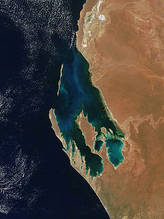
Shark Bay is a World Heritage Site in the Gascoyne region of Western Australia. The 23,000-square-kilometre (8,900 sq mi) area is located approximately 800 kilometres (500 mi) north of Perth, on the westernmost point of the Australian continent. UNESCO's official listing of Shark Bay as a World Heritage Site reads:

Greater Western Sydney (GWS) is a large region of the metropolitan area of Greater Sydney, New South Wales, Australia that generally embraces the north-west, south-west, central-west, and far western sub-regions within Sydney's metropolitan area and encompasses 12 local government areas: Blacktown, Canterbury-Bankstown, Camden, Campbelltown, Cumberland, Fairfield, Hawkesbury, Hills Shire, Liverpool, Parramatta, Penrith and Wollondilly. It includes Western Sydney, which has a number of different definitions, although the one consistently used is the region composed of ten local government authorities, most of which are members of the Western Sydney Regional Organisation of Councils (WSROC). Penrith, Hills Shire & Canterbury-Bankstown are not WSROC members. The NSW Government's Office of Western Sydney uses the broader Greater Western Sydney definition to refer to the region.
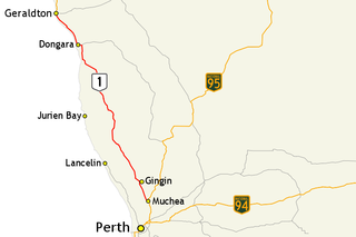
Brand Highway is a 370-kilometre (230 mi) main highway linking the northern outskirts of Perth to Geraldton in Western Australia. Together with North West Coastal Highway, it forms part of the Western Australian coastal link to the Northern Territory. The highway is a part of Australia's Highway 1, and is for the most part a single carriageway with one lane in each direction.

Great Northern Highway is an Australian highway that links Western Australia's capital city Perth with its northernmost port, Wyndham. With a length of almost 3,200 kilometres (2,000 mi), it is the longest highway in Australia, with the majority included as part of the Perth Darwin National Highway. The highway is constructed as a sealed, predominantly two-lane single carriageway, but with some single-lane bridges in the Kimberley. The Great Northern Highway travels through remote areas of the state, and is the only sealed road link between the Northern Territory and northern Western Australia. Economically, it provides vital access through the Wheatbelt and Mid West to the resource-rich regions of the Pilbara and Kimberley. In these areas, the key industries of mining, agriculture and pastoral stations, and tourism are all dependent on the highway.

North West Coastal Highway is a generally north-south Western Australian highway which links the coastal city of Geraldton with the town of Port Hedland. The 1,300-kilometre-long (808 mi) road, constructed as a sealed two-lane single carriageway, travels through remote and largely arid landscapes. Carnarvon is the only large settlement on the highway, and is an oasis within the harsh surrounding environment. The entire highway is allocated National Route 1, part of Australia's Highway 1, and parts of the highway are included in tourist routes Batavia Coast Tourist Way and Cossack Tourist Way. Economically, North West Coastal Highway is an important link to the Mid West, Gascoyne and Pilbara regions, supporting the agricultural, pastoral, fishing, and tourism industries, as well as mining and offshore oil and gas production.

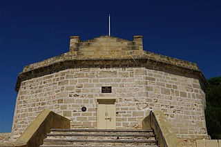
Anthony O'Grady Lefroy, often known as O'Grady Lefroy, was an important government official in Western Australia before the advent of responsible government.

The Shire of Moora is a local government area in the northern Wheatbelt region of Western Australia, and generally lies between the Brand Highway and Great Northern Highway about 180 kilometres (112 mi) north of Perth, the state capital. The Shire covers an area of 3,767 square kilometres (1,454 sq mi) and its seat of government is the town of Moora.
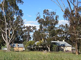
The Heritage Council of Western Australia is the Government of Western Australia agency created to identify, conserve and promote places of cultural heritage significance in the state.

Lambertia multiflora, commonly known as many-flowered honeysuckle, is a multi-stemmed shrub which is endemic to the south-west of Western Australia. It grows to between 0.5 and 2.5 metres high and flowers from winter to summer.

Adenanthos meisneri, commonly known as prostrate woollybush, is a species of shrub in the family Proteaceae. It is endemic to the south-west of Western Australia.

Adenanthos pungens, the spiky adenanthos, is a species of shrub in the family Proteaceae. It is endemic to the south-west of Western Australia.

Adenanthos × cunninghamii, commonly known as woollybush, Albany woollybush or prostrate woollybush, is a hybrid shrub in the family Proteaceae. It is endemic to the south-west of Western Australia.
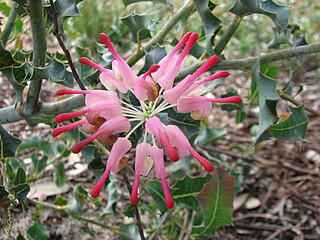
Grevillea insignis, commonly known as wax grevillea, is a shrub species which is endemic to the south-west of Western Australia. The species was first formally described in 1855 in Hooker's Journal of Botany and Kew Garden Miscellany.
Tourist Drives in Western Australia are routes through areas of scenic or historic significance, designated by route markers with white numbers on a brown shield. Tourist Drives were introduced into Western Australia while Eric Charlton was the state government Minister for Transport in the 1990s. The 28 numbered routes collectively traverse more than 2,000 kilometres (1,200 mi) across the state. In addition to the Tourist Drives, there are unnumbered routes such as the Golden Pipeline Heritage Trail, and local governments may designate and maintain local scenic drives, generally unnamed and unnumbered.

Benedict "Ben" Taylor AM, also known as Cuimara is a Noongar elder from the south-west of Western Australia. Taylor is a well-known Indigenous activist.
The State Register of Heritage Places is the heritage register of historic sites in Western Australia deemed significant at the state level by the Heritage Council of Western Australia.

Yued is a region inhabited by the Yued people, one of the fourteen groups of Noongar Aboriginal Australians who have lived in the South West corner of Western Australia for approximately 40,000 years.