
Toodyay, known as Newcastle between 1860 and 1910, is a town on the Avon River in the Wheatbelt region of Western Australia, 85 kilometres (53 mi) north-east of Perth. The first European settlement occurred in the area in 1836. After flooding in the 1850s, the townsite was moved to its current location in the 1860s. It is connected by railway and road to Perth. During the 1860s, it was home to bushranger Moondyne Joe.
Torbay is a small town and a bay in the Great Southern region of Western Australia, 20 kilometres (12 mi) west of Albany. Torbay is within the City of Albany local government area. The Torbay townsite was gazetted in 1910.

Babakin is a small town located in the Wheatbelt region of Western Australia between the towns of Bruce Rock and Corrigin. At the 2021 census the population of Babakin was 56. Facilities in the town include a school, shop, hall and sporting facilities.
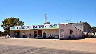
Cadoux is a town in the northeastern Wheatbelt region of Western Australia. It is about 180 kilometres (112 mi) northeast of Perth, within the Shire of Wongan-Ballidu.
Boolardy Station is a remote former sheep and cattle station in the Mid West (Murchison) region of Western Australia, about 194 km (121 mi) north-north-east of Pindar and 200 km (120 mi) west-south-west of Meekatharra. It is within the Shire of Murchison and situated on pastoral lease no. 3114/406. The area of the lease is 3,467.48 square kilometres (1,338.80 sq mi).

Pithara is a small town in the Wheatbelt region of Western Australia. It is located about 240 km north of Perth, in the Shire of Dalwallinu. At the 2011 census, Pithara had a population of 257, a 25% fall from the previous 2006 census.

Gwambygine Homestead is one of the earliest colonial buildings still remaining in Western Australia. Until the death in 1998 of the last occupant, Merton Clifton, the house had the reputation of being the oldest continually occupied house in the state.

Mulga Downs Station is a pastoral lease that once operated as a sheep station but is currently operating as a cattle station in Western Australia.
Nanutarra Station, commonly referred to as Nanutarra, is a pastoral lease that operates as a cattle station, and previously operated as a sheep station, in Western Australia.
White Peak Station, also known as White Peak Homestead, is a property situated in the Shire of Chapman Valley approximately 16 kilometres (10 mi) north north east of Geraldton in the Mid West region of Western Australia. The White Peak Homestead was one of the five original pastoral leases established in the region. It was settled by John Drummond, a pioneer pastoralist. The homestead and surroundings retain the homestead building, which is notable for its large scale and grand detailing in comparison with other farmhouses in the region. Outbuildings including stone stables, tack room, shearing shed, machinery sheds are still in place, although some original stone walls have been demolished.

Mumballup is a locality in the South West region of Western Australia, situated between Collie and Boyup Brook, 221 kilometres (137 mi) south of Perth. The town is in the Shire of Donnybrook-Balingup.
Beelerup is a rural locality of the Shire of Donnybrook–Balingup in the South West region of Western Australia, along the Preston River.

Glen Mervyn is a rural locality of the Shire of Donnybrook–Balingup in the South West region of Western Australia. The Preston River and the Donnybrook–Boyup Brook Road run through the centre of the locality from east to west. The Glen Mervyn Dam and reservoir is located on the north-eastern boundary of the locality, with the dam itself being located on the Mumballup side of the border.

Lowden is a rural locality of the Shire of Donnybrook–Balingup in the South West region of Western Australia. The Preston River and the Donnybrook–Boyup Brook Road run through the centre of the locality from east to west.
Yabberup is a rural locality of the Shire of Donnybrook–Balingup in the South West region of Western Australia. The Preston River and the Donnybrook–Boyup Brook Road run through the centre of the locality from east to west. A small north-western corner of the Greater Preston National Park extends into the south-east of the locality.

Noggerup is a rural town and locality of the Shire of Donnybrook–Balingup in the South West region of Western Australia. A large portion of the Greater Preston National Park is located within Noggerup.
Queenwood is a rural locality of the Shire of Donnybrook–Balingup in the South West region of Western Australia. The Preston River and the Donnybrook–Boyup Brook Road run through the locality from east to west.

Barrabup is a rural locality of the Shire of Nannup in the South West region of Western Australia. The eastern boundary of the locality is formed by the Vasse Highway, with much of the locality being covered by state forest.

